Crockett County Sketch File 75a
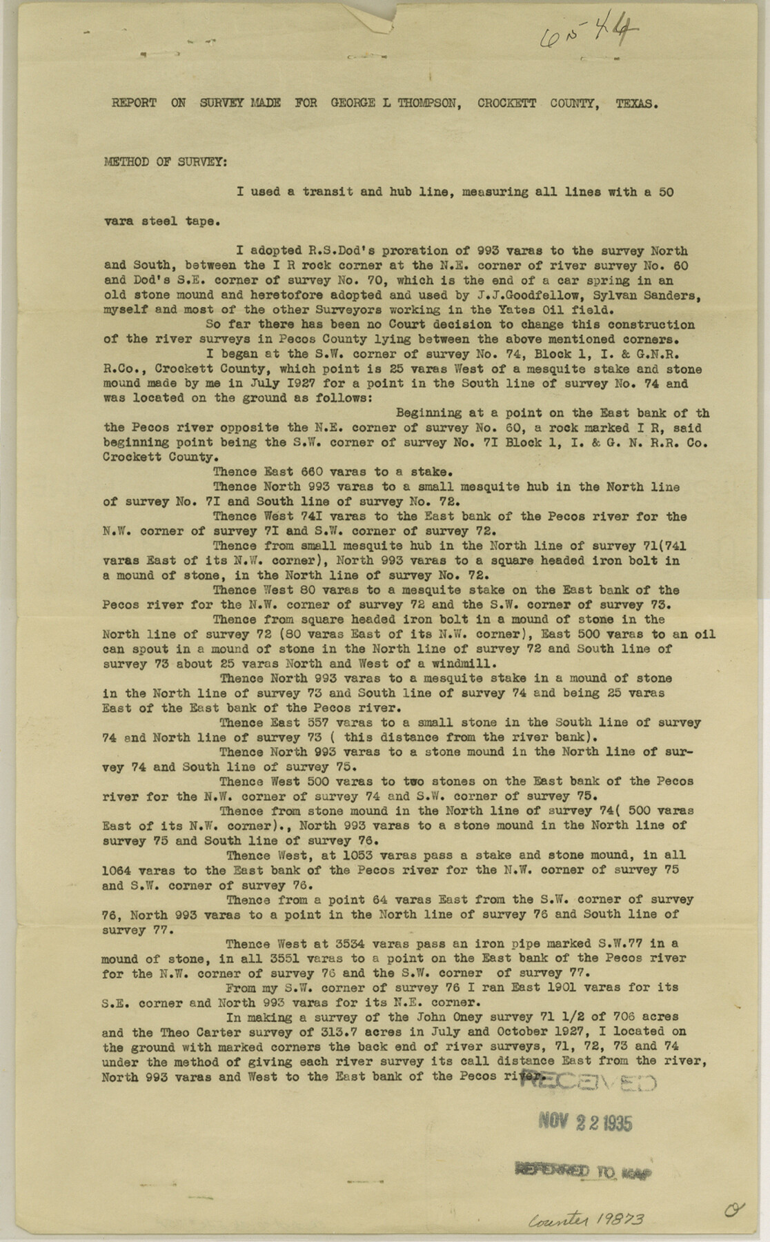
[Report on survey made for George L. Thompson]
-
Map/Doc
19873
-
Collection
General Map Collection
-
Object Dates
1935/11/22 (File Date)
1927 (Survey Date)
1928 (Survey Date)
1935 (Survey Date)
-
People and Organizations
J.A. Simpson (Surveyor/Engineer)
R.S. Dod (Surveyor/Engineer)
J.J. Goodfellow (Surveyor/Engineer)
Sylvan Sanders (Surveyor/Engineer)
-
Counties
Crockett Pecos
-
Subjects
Surveying Sketch File
-
Height x Width
14.2 x 8.8 inches
36.1 x 22.4 cm
-
Medium
paper, print
-
Features
Pecos River
Part of: General Map Collection
Kaufman County

Print $20.00
- Digital $50.00
Kaufman County
1854
Size 30.8 x 24.2 inches
Map/Doc 78485
Palo Pinto County Rolled Sketch 9

Print $40.00
- Digital $50.00
Palo Pinto County Rolled Sketch 9
Size 78.0 x 30.9 inches
Map/Doc 9675
Madison County Working Sketch 2

Print $20.00
- Digital $50.00
Madison County Working Sketch 2
1933
Size 23.4 x 25.5 inches
Map/Doc 70764
Plat of South 1/2 of Colorado River Channel in McCulloch Co., Texas from Concho County line down river 34 mile 315 varas

Print $40.00
- Digital $50.00
Plat of South 1/2 of Colorado River Channel in McCulloch Co., Texas from Concho County line down river 34 mile 315 varas
1918
Size 41.5 x 104.6 inches
Map/Doc 2463
Flight Mission No. CRE-2R, Frame 154, Jackson County

Print $20.00
- Digital $50.00
Flight Mission No. CRE-2R, Frame 154, Jackson County
1956
Size 16.1 x 16.0 inches
Map/Doc 85365
Ochiltree County Working Sketch Graphic Index

Print $20.00
- Digital $50.00
Ochiltree County Working Sketch Graphic Index
1958
Size 41.5 x 32.8 inches
Map/Doc 76656
Topographical Map of the Rio Grande, Sheet No. 18

Print $20.00
- Digital $50.00
Topographical Map of the Rio Grande, Sheet No. 18
1912
Map/Doc 89542
Hays County Working Sketch 19

Print $20.00
- Digital $50.00
Hays County Working Sketch 19
1980
Size 30.1 x 26.0 inches
Map/Doc 66093
McCulloch County Sketch File 3

Print $12.00
- Digital $50.00
McCulloch County Sketch File 3
1893
Size 11.1 x 8.5 inches
Map/Doc 31169
Borden County Working Sketch 11

Print $40.00
- Digital $50.00
Borden County Working Sketch 11
1955
Size 51.6 x 26.5 inches
Map/Doc 67471
Duval County Sketch File 15

Print $4.00
- Digital $50.00
Duval County Sketch File 15
Size 12.0 x 9.0 inches
Map/Doc 21309
Flight Mission No. CRC-5R, Frame 33, Chambers County

Print $20.00
- Digital $50.00
Flight Mission No. CRC-5R, Frame 33, Chambers County
1956
Size 18.6 x 22.5 inches
Map/Doc 84952
You may also like
Flight Mission No. DAG-23K, Frame 179, Matagorda County

Print $20.00
- Digital $50.00
Flight Mission No. DAG-23K, Frame 179, Matagorda County
1953
Size 18.5 x 22.4 inches
Map/Doc 86514

Kleberg County Rolled Sketch 10-21

Print $20.00
- Digital $50.00
Kleberg County Rolled Sketch 10-21
1952
Size 37.5 x 32.9 inches
Map/Doc 9403
Newton County Sketch File 38

Print $6.00
- Digital $50.00
Newton County Sketch File 38
Size 16.1 x 11.0 inches
Map/Doc 32417
Flight Mission No. CRC-5R, Frame 31, Chambers County

Print $20.00
- Digital $50.00
Flight Mission No. CRC-5R, Frame 31, Chambers County
1956
Size 18.5 x 22.4 inches
Map/Doc 84950
A Map of the Indian Territory, Northern Texas and New Mexico Showing the Great Western Prairies

Print $20.00
- Digital $50.00
A Map of the Indian Territory, Northern Texas and New Mexico Showing the Great Western Prairies
1844
Size 14.0 x 17.6 inches
Map/Doc 95700
Galveston County NRC Article 33.136 Sketch 84

Print $62.00
- Digital $50.00
Galveston County NRC Article 33.136 Sketch 84
2017
Size 17.2 x 22.0 inches
Map/Doc 94854
Morris County Sketch File 1

Print $4.00
- Digital $50.00
Morris County Sketch File 1
Size 12.4 x 6.5 inches
Map/Doc 31963
Dimmit County Rolled Sketch 10
Print $20.00
- Digital $50.00
Dimmit County Rolled Sketch 10
1941
Size 29.2 x 32.1 inches
Map/Doc 5719
[Surveys near Lake Soda made under G.W. Smyth, Commissioner]
![73, [Surveys near Lake Soda made under G.W. Smyth, Commissioner], General Map Collection](https://historictexasmaps.com/wmedia_w700/maps/73.tif.jpg)
Print $20.00
- Digital $50.00
[Surveys near Lake Soda made under G.W. Smyth, Commissioner]
1835
Size 16.0 x 19.3 inches
Map/Doc 73
Newton County Working Sketch 42

Print $20.00
- Digital $50.00
Newton County Working Sketch 42
1981
Size 26.4 x 22.5 inches
Map/Doc 71288
Freestone County

Print $20.00
- Digital $50.00
Freestone County
1988
Size 43.0 x 41.8 inches
Map/Doc 77284