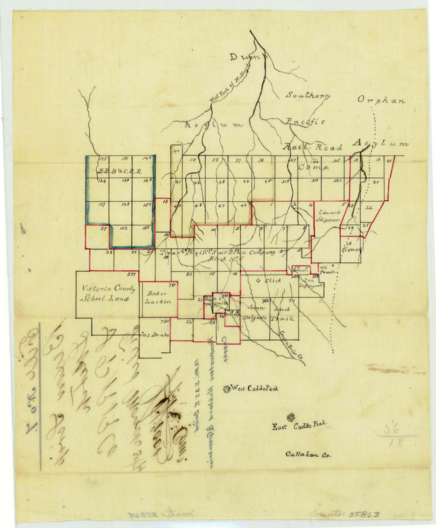
Callahan County Sketch File 7
[Multiple sketches of various railroad blocks in the county north, northeast, and southeast from Baird]
-
Map/Doc
35863
-
Collection
General Map Collection
-
Object Dates
1874 (File Date)
-
Counties
Callahan
-
Subjects
Surveying Sketch File
-
Height x Width
10.8 x 8.9 inches
27.4 x 22.6 cm
-
Medium
paper, manuscript
-
Features
West Fork of Hubbard Creek
Green Briar Creek
West Caddo Peak
East Caddo Peak
Part of: General Map Collection
Gregg County Working Sketch 17

Print $20.00
- Digital $50.00
Gregg County Working Sketch 17
1950
Size 29.7 x 26.2 inches
Map/Doc 63284
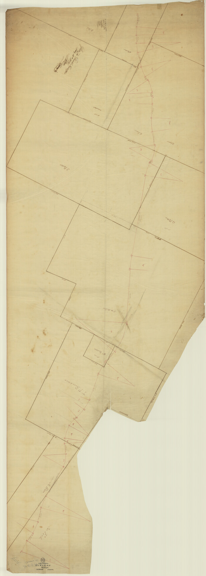
Location St. L. & S. W. R. R. Through Cherokee County
Print $40.00
- Digital $50.00
Location St. L. & S. W. R. R. Through Cherokee County
Size 108.6 x 39.0 inches
Map/Doc 64043
Rucker's Work on Upper Red River

Print $20.00
- Digital $50.00
Rucker's Work on Upper Red River
1857
Size 39.3 x 26.2 inches
Map/Doc 3220
Gregg County Rolled Sketch 26

Print $40.00
- Digital $50.00
Gregg County Rolled Sketch 26
1937
Size 26.4 x 126.6 inches
Map/Doc 76432
Montague County Sketch File 12

Print $4.00
- Digital $50.00
Montague County Sketch File 12
Size 11.4 x 8.2 inches
Map/Doc 31736
Flight Mission No. DQN-7K, Frame 16, Calhoun County

Print $20.00
- Digital $50.00
Flight Mission No. DQN-7K, Frame 16, Calhoun County
1953
Size 18.5 x 22.1 inches
Map/Doc 84467
Fort Bend County Sketch File 16 1/2

Print $16.00
- Digital $50.00
Fort Bend County Sketch File 16 1/2
Size 14.3 x 8.8 inches
Map/Doc 22927
Pecos County Working Sketch 55

Print $20.00
- Digital $50.00
Pecos County Working Sketch 55
1948
Size 38.4 x 27.7 inches
Map/Doc 71527
King County Sketch File 10

Print $24.00
- Digital $50.00
King County Sketch File 10
1902
Size 14.2 x 8.7 inches
Map/Doc 29083
Flight Mission No. DQN-7K, Frame 89, Calhoun County

Print $20.00
- Digital $50.00
Flight Mission No. DQN-7K, Frame 89, Calhoun County
1953
Size 18.4 x 22.2 inches
Map/Doc 84480
Moore County Rolled Sketch 12

Print $20.00
- Digital $50.00
Moore County Rolled Sketch 12
Size 24.9 x 22.7 inches
Map/Doc 6828
Map of Colorado County

Print $20.00
- Digital $50.00
Map of Colorado County
1871
Size 18.0 x 18.8 inches
Map/Doc 3425
You may also like
[Surveys along the Sabine River made under G.W. Smyth, Commissioner]
![90, [Surveys along the Sabine River made under G.W. Smyth, Commissioner], General Map Collection](https://historictexasmaps.com/wmedia_w700/maps/90.tif.jpg)
Print $20.00
- Digital $50.00
[Surveys along the Sabine River made under G.W. Smyth, Commissioner]
1837
Size 13.9 x 17.0 inches
Map/Doc 90
[Leagues 622, 621]
![92170, [Leagues 622, 621], Twichell Survey Records](https://historictexasmaps.com/wmedia_w700/maps/92170-1.tif.jpg)
Print $20.00
- Digital $50.00
[Leagues 622, 621]
Size 24.2 x 19.8 inches
Map/Doc 92170
Bell County, Texas

Print $20.00
- Digital $50.00
Bell County, Texas
1879
Size 23.7 x 29.0 inches
Map/Doc 516
Cottle County Sketch File A1

Print $34.00
- Digital $50.00
Cottle County Sketch File A1
1882
Size 15.7 x 29.1 inches
Map/Doc 11199
Matagorda Bay and Approaches

Print $20.00
- Digital $50.00
Matagorda Bay and Approaches
1946
Size 35.2 x 44.8 inches
Map/Doc 73379
Presidio County Rolled Sketch 146

Print $20.00
- Digital $50.00
Presidio County Rolled Sketch 146
2018
Size 29.8 x 41.8 inches
Map/Doc 95821
[Sections 155-162, Toyah Creek Irrigation Company and surrounding surveys]
![91037, [Sections 155-162, Toyah Creek Irrigation Company and surrounding surveys], Twichell Survey Records](https://historictexasmaps.com/wmedia_w700/maps/91037-1.tif.jpg)
Print $20.00
- Digital $50.00
[Sections 155-162, Toyah Creek Irrigation Company and surrounding surveys]
1916
Size 12.8 x 38.7 inches
Map/Doc 91037
Fractional Township No. 9 South Range No. 24 East of the Indian Meridian, Indian Territory

Print $20.00
- Digital $50.00
Fractional Township No. 9 South Range No. 24 East of the Indian Meridian, Indian Territory
1898
Size 19.2 x 24.3 inches
Map/Doc 75241
Liberty County Boundary File 2

Print $9.00
- Digital $50.00
Liberty County Boundary File 2
Size 17.0 x 11.0 inches
Map/Doc 56293
Victoria County Sketch File 8

Print $2.00
- Digital $50.00
Victoria County Sketch File 8
Size 5.7 x 5.6 inches
Map/Doc 39524
San Augustine County Sketch File 20

Print $82.00
- Digital $50.00
San Augustine County Sketch File 20
1951
Size 8.9 x 14.4 inches
Map/Doc 35680
Chambers County Sketch File 43

Print $13.00
- Digital $50.00
Chambers County Sketch File 43
Size 14.3 x 9.6 inches
Map/Doc 17729