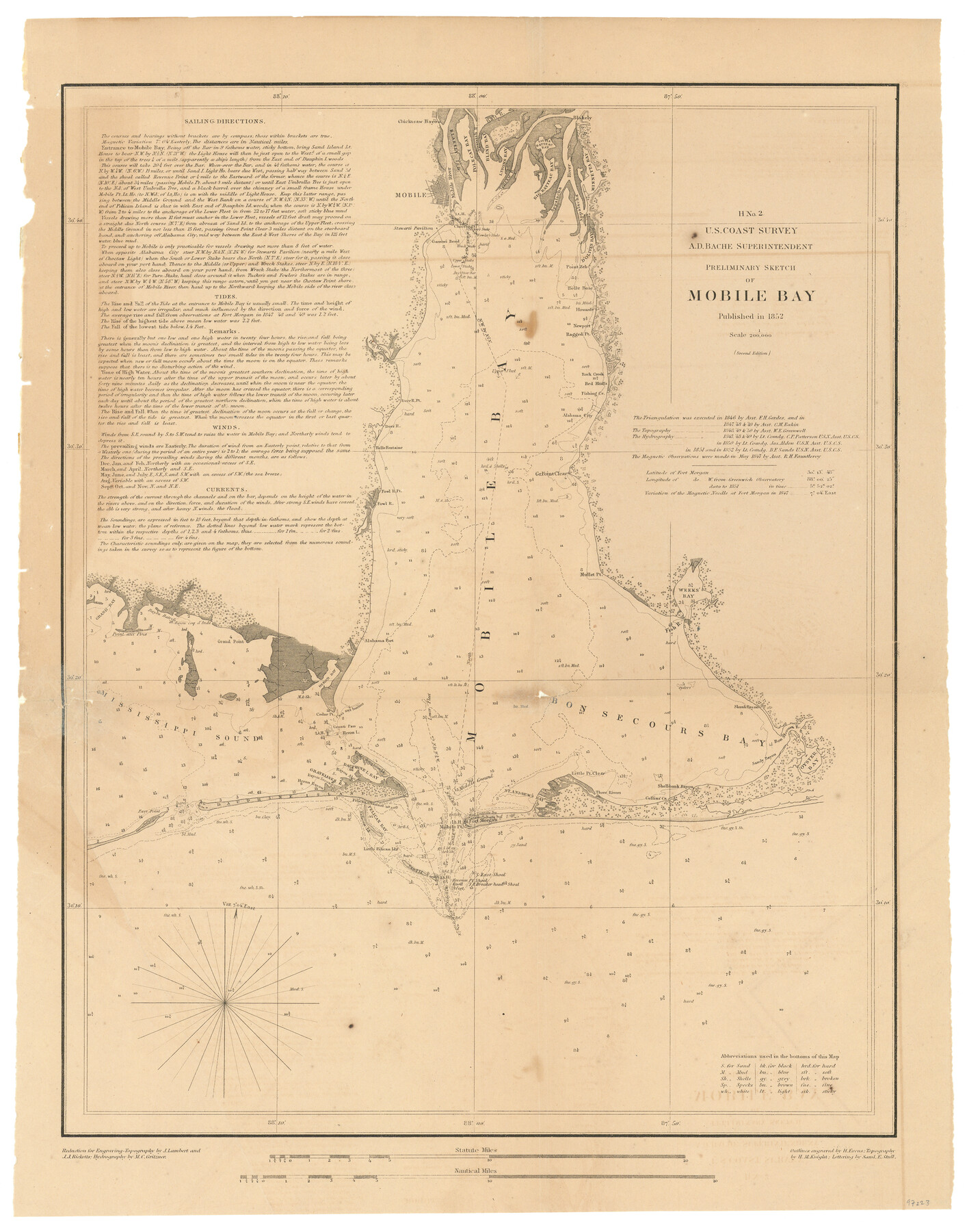
H No. 2 - Preliminary Sketch of Mobile Bay
- 
                          Map/Doc
97223
 - 
                            Collection
General Map Collection
 - 
                            Object Dates
1852 (Creation Date)
 - 
                            People and Organizations
A.D. Bache (Superintendent)
U.S. Coast Survey (Publisher)
 - 
                            Subjects
Coastal
 - 
                            Height x Width
19.4 x 15.2 inches
49.3 x 38.6 cm
 - 
                            Comments
Sketch from the book "Report of the Superintendent of the Coast Survey Showing the Progress of the Survey in the year 1852" (81738)
 
Related maps
            Report of the Superintendent of the Coast Survey showing the progress of the survey during the year 1852


            Report of the Superintendent of the Coast Survey showing the progress of the survey during the year 1852
1853
Map/Doc 81738
            Part of: General Map Collection
            Old Miscellaneous File 11


                                            Print $4.00                    
                                             -                         Digital $50.00                                    
                Old Miscellaneous File 11
1886
Size 11.2 x 8.8 inches
                                Map/Doc 75437
            
            City of Austin and Vicinity


                                            Print $20.00                    
                                             -                         Digital $50.00                                    
                City of Austin and Vicinity
1839
Size 20.4 x 19.6 inches
                                Map/Doc 3149
            
            Brewster County Working Sketch 70


                                            Print $20.00                    
                                             -                         Digital $50.00                                    
                Brewster County Working Sketch 70
1961
Size 30.5 x 44.0 inches
                                Map/Doc 67671
            
            Flight Mission No. BQR-9K, Frame 50, Brazoria County


                                            Print $20.00                    
                                             -                         Digital $50.00                                    
                Flight Mission No. BQR-9K, Frame 50, Brazoria County
1952
Size 18.7 x 22.4 inches
                                Map/Doc 84054
            
            Flight Mission No. DQO-8K, Frame 77, Galveston County


                                            Print $20.00                    
                                             -                         Digital $50.00                                    
                Flight Mission No. DQO-8K, Frame 77, Galveston County
1952
Size 18.9 x 22.5 inches
                                Map/Doc 85181
            
            Tyler County Working Sketch 15


                                            Print $20.00                    
                                             -                         Digital $50.00                                    
                Tyler County Working Sketch 15
1960
Size 23.8 x 18.1 inches
                                Map/Doc 69485
            
            Flight Mission No. CUG-3P, Frame 139, Kleberg County


                                            Print $20.00                    
                                             -                         Digital $50.00                                    
                Flight Mission No. CUG-3P, Frame 139, Kleberg County
1956
Size 18.6 x 22.4 inches
                                Map/Doc 86274
            
            Current Miscellaneous File 33


                                            Print $6.00                    
                                             -                         Digital $50.00                                    
                Current Miscellaneous File 33
1953
Size 10.8 x 8.2 inches
                                Map/Doc 73939
            
            Live Oak County Rolled Sketch 8


                                            Print $20.00                    
                                             -                         Digital $50.00                                    
                Live Oak County Rolled Sketch 8
1969
Size 43.5 x 32.8 inches
                                Map/Doc 9455
            
            Armstrong County Working Sketch 8


                                            Print $20.00                    
                                             -                         Digital $50.00                                    
                Armstrong County Working Sketch 8
1902
Size 25.4 x 40.2 inches
                                Map/Doc 67239
            
            Sabine County Sketch File 1


                                            Print $2.00                    
                                    
                Sabine County Sketch File 1
Size 14.2 x 7.7 inches
                                Map/Doc 35601
            You may also like
            San Patricio County Aerial Photograph Index Sheet 4


                                            Print $20.00                    
                                             -                         Digital $50.00                                    
                San Patricio County Aerial Photograph Index Sheet 4
1957
Size 23.3 x 19.3 inches
                                Map/Doc 83746
            
            Rain Chart of the United States showing by isohyetal lines the distribution of the mean annual precipitation in rain and melted snow


                                            Print $20.00                    
                                    
                Rain Chart of the United States showing by isohyetal lines the distribution of the mean annual precipitation in rain and melted snow
1878
Size 20.8 x 29.4 inches
                                Map/Doc 95190
            
            Plan of the cities of Denver, Auraria and Highland, Jefferson Terr.


                                            Print $20.00                    
                                             -                         Digital $50.00                                    
                Plan of the cities of Denver, Auraria and Highland, Jefferson Terr.
1859
Size 23.7 x 29.8 inches
                                Map/Doc 94053
            
            Val Verde County Rolled Sketch 59


                                            Print $20.00                    
                                             -                         Digital $50.00                                    
                Val Verde County Rolled Sketch 59
1947
Size 45.2 x 23.6 inches
                                Map/Doc 10078
            
            Milam County Boundary File 2


                                            Print $30.00                    
                                             -                         Digital $50.00                                    
                Milam County Boundary File 2
Size 12.7 x 8.2 inches
                                Map/Doc 57202
            
            Fractional Township No. 6 South Range No. 8 West of the Indian Meridian, Indian Territory


                                            Print $20.00                    
                                             -                         Digital $50.00                                    
                Fractional Township No. 6 South Range No. 8 West of the Indian Meridian, Indian Territory
1898
Size 19.2 x 24.4 inches
                                Map/Doc 75156
            
            Flight Mission No. BRE-1P, Frame 7, Nueces County


                                            Print $20.00                    
                                             -                         Digital $50.00                                    
                Flight Mission No. BRE-1P, Frame 7, Nueces County
1956
Size 18.3 x 22.1 inches
                                Map/Doc 86615
            
            Pecos County Rolled Sketch 105


                                            Print $20.00                    
                                             -                         Digital $50.00                                    
                Pecos County Rolled Sketch 105
1940
Size 30.7 x 37.7 inches
                                Map/Doc 9717
            
            Pecos County Rolled Sketch 26A


                                            Print $40.00                    
                                             -                         Digital $50.00                                    
                Pecos County Rolled Sketch 26A
1890
Size 56.4 x 19.5 inches
                                Map/Doc 9689
            
            Childress Co.


                                            Print $20.00                    
                                             -                         Digital $50.00                                    
                Childress Co.
1892
Size 40.3 x 33.7 inches
                                Map/Doc 66752
            
            Flight Mission No. CRC-2R, Frame 197, Chambers County


                                            Print $20.00                    
                                             -                         Digital $50.00                                    
                Flight Mission No. CRC-2R, Frame 197, Chambers County
1956
Size 18.7 x 22.5 inches
                                Map/Doc 84775