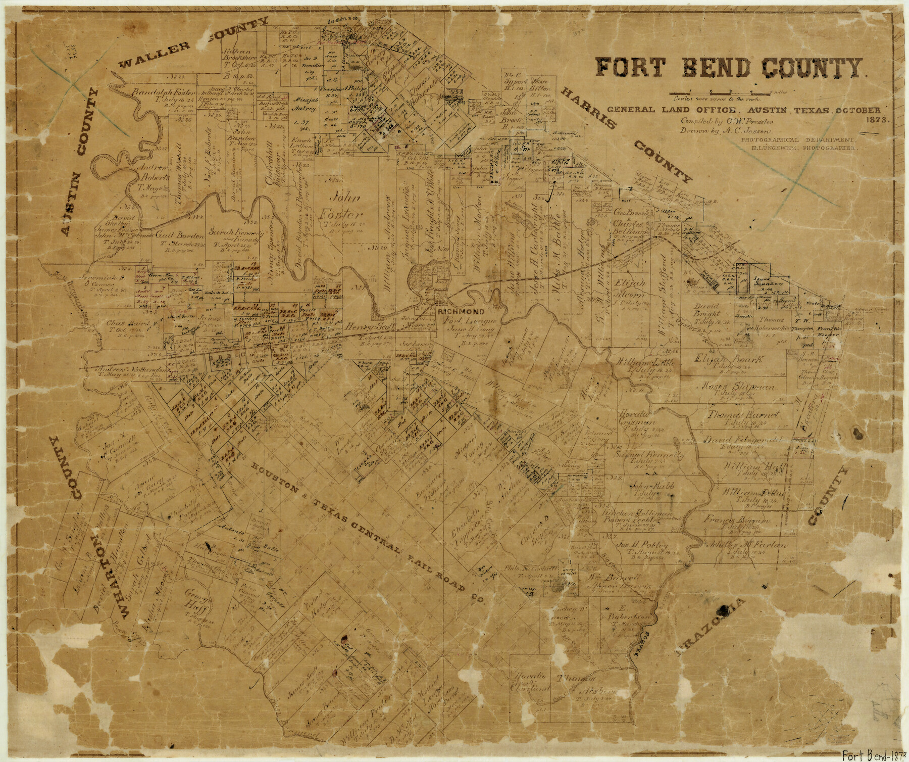
Fort Bend County
-
Map/Doc
3555
-
Collection
General Map Collection
-
Object Dates
10/1873 (Creation Date)
-
People and Organizations
Chas. W. Pressler (Compiler)
Herman Lungwitz (Draftsman)
A.C. Jessen (Draftsman)
-
Counties
Fort Bend
-
Subjects
County
-
Height x Width
18.0 x 21.4 inches
45.7 x 54.4 cm
-
Features
BBB&C
Snake Creek
Bowie Creek
Lake Wieden
Cow Creek
Bee Creek
Peach Creek
West Bernard River
Big Creek
West Prong [of Big Creek]
Turkey Creek
TWNG
Randoms Lake
HT&B
Buffalo Bayou
Richmond
[Brazos River] Slough
Brazos River
Oyster Bayou
Clear Creek
Bray's Bayou
Jones Creek
Round Lake
Rush Lake
Crooked Lake
Lake Jane
San Bernard River
Part of: General Map Collection
San Saba County Working Sketch 11

Print $20.00
- Digital $50.00
San Saba County Working Sketch 11
1989
Size 30.3 x 38.2 inches
Map/Doc 63799
Erath County Sketch File 22

Print $4.00
- Digital $50.00
Erath County Sketch File 22
1853
Size 8.4 x 8.4 inches
Map/Doc 22304
Cameron County NRC Article 33.136 Location Key Sheet

Print $20.00
- Digital $50.00
Cameron County NRC Article 33.136 Location Key Sheet
1983
Size 27.0 x 23.0 inches
Map/Doc 89294
La Salle County Boundary File 57

Print $26.00
- Digital $50.00
La Salle County Boundary File 57
Size 9.2 x 4.7 inches
Map/Doc 56242
Surveys in Austin's Colony along the east fork of Mill Creek

Print $20.00
- Digital $50.00
Surveys in Austin's Colony along the east fork of Mill Creek
1830
Size 23.7 x 12.6 inches
Map/Doc 208
Reagan County Rolled Sketch 29

Print $20.00
- Digital $50.00
Reagan County Rolled Sketch 29
1954
Size 35.6 x 35.4 inches
Map/Doc 9824
Ward County Working Sketch 35

Print $20.00
- Digital $50.00
Ward County Working Sketch 35
1968
Size 46.4 x 43.0 inches
Map/Doc 72341
Harris County Sketch File 33a

Print $20.00
- Digital $50.00
Harris County Sketch File 33a
Size 34.1 x 30.0 inches
Map/Doc 10478
Cameron County Rolled Sketch 20D

Print $20.00
- Digital $50.00
Cameron County Rolled Sketch 20D
Size 14.3 x 13.9 inches
Map/Doc 5477
Sabine River, North Extension Merrill Lake Sheet

Print $20.00
- Digital $50.00
Sabine River, North Extension Merrill Lake Sheet
1933
Size 23.2 x 42.6 inches
Map/Doc 65140
Map of Blanco County

Print $20.00
- Digital $50.00
Map of Blanco County
1871
Size 22.1 x 17.2 inches
Map/Doc 3304
Flight Mission No. DQN-1K, Frame 51, Calhoun County

Print $20.00
- Digital $50.00
Flight Mission No. DQN-1K, Frame 51, Calhoun County
1953
Size 18.6 x 22.3 inches
Map/Doc 84151
You may also like
PSL Field Notes for Blocks I, O, and X in Hockley and Terry Counties and Blocks A and D in Hockley County

PSL Field Notes for Blocks I, O, and X in Hockley and Terry Counties and Blocks A and D in Hockley County
Map/Doc 81657
Maps of Gulf Intracoastal Waterway, Texas - Sabine River to the Rio Grande and connecting waterways including ship channels

Print $20.00
- Digital $50.00
Maps of Gulf Intracoastal Waterway, Texas - Sabine River to the Rio Grande and connecting waterways including ship channels
1966
Size 14.6 x 22.3 inches
Map/Doc 61950
San Patricio County Rolled Sketch 46D

Print $20.00
- Digital $50.00
San Patricio County Rolled Sketch 46D
1983
Size 14.8 x 36.0 inches
Map/Doc 8375
Jefferson County Rolled Sketch 33

Print $20.00
- Digital $50.00
Jefferson County Rolled Sketch 33
1956
Size 46.8 x 27.5 inches
Map/Doc 6393
Bandera County Working Sketch 56

Print $20.00
- Digital $50.00
Bandera County Working Sketch 56
1991
Size 28.1 x 35.1 inches
Map/Doc 67652

[Beaumont, Sour Lake and Western Ry. Right of Way and Alignment - Frisco]
![64123, [Beaumont, Sour Lake and Western Ry. Right of Way and Alignment - Frisco], General Map Collection](https://historictexasmaps.com/wmedia_w700/maps/64123.tif.jpg)
Print $20.00
- Digital $50.00
[Beaumont, Sour Lake and Western Ry. Right of Way and Alignment - Frisco]
1910
Size 20.4 x 46.2 inches
Map/Doc 64123
Mills County Working Sketch 10

Print $20.00
- Digital $50.00
Mills County Working Sketch 10
1928
Size 29.0 x 22.0 inches
Map/Doc 71040
Harbor of Brazos Santiago, Texas

Print $20.00
- Digital $50.00
Harbor of Brazos Santiago, Texas
1887
Size 27.1 x 18.3 inches
Map/Doc 72995
Jefferson County Working Sketch 37

Print $40.00
- Digital $50.00
Jefferson County Working Sketch 37
1982
Size 49.9 x 36.6 inches
Map/Doc 66581
Cochran County Rolled Sketch 1

Print $40.00
- Digital $50.00
Cochran County Rolled Sketch 1
1938
Size 61.8 x 18.0 inches
Map/Doc 8606
[Sketch showing B. S. & F. Block 9 and vicinity]
![89785, [Sketch showing B. S. & F. Block 9 and vicinity], Twichell Survey Records](https://historictexasmaps.com/wmedia_w700/maps/89785-1.tif.jpg)
Print $40.00
- Digital $50.00
[Sketch showing B. S. & F. Block 9 and vicinity]
Size 37.8 x 49.0 inches
Map/Doc 89785