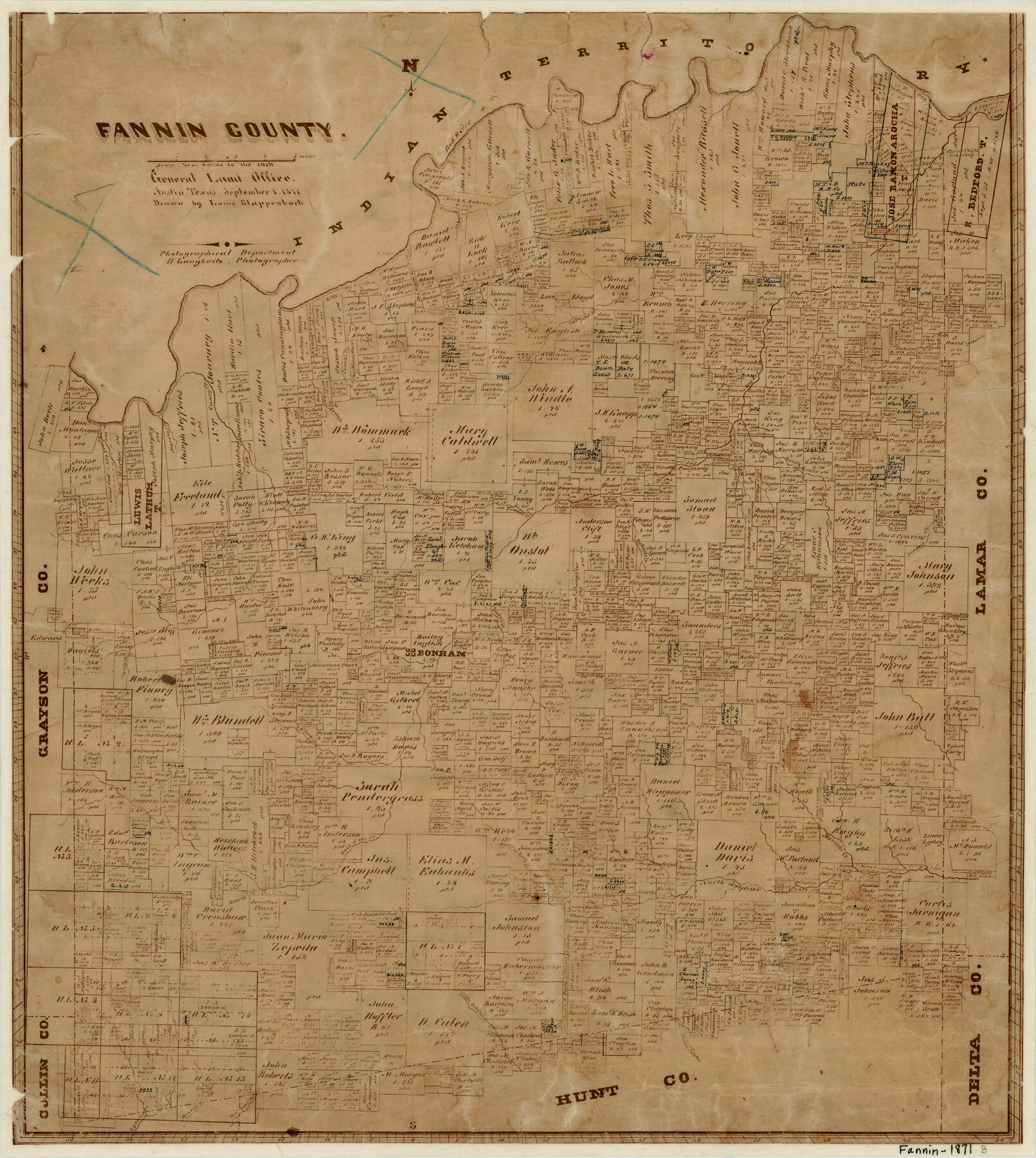
Fannin County
-
Map/Doc
3533
-
Collection
General Map Collection
-
Object Dates
9/1/1871 (Creation Date)
-
People and Organizations
Herman Lungkwitz (Draftsman)
Louis Klappenbach (Draftsman)
-
Counties
Fannin
-
Subjects
County
-
Height x Width
18.9 x 17.0 inches
48.0 x 43.2 cm
-
Features
South Sulphur Creek
Bullard's Creek
Powder Creek
Bonham
McCung's Creek
Mercell's Creek
North Sulphur Creek
Davis Creek
Rock Creek
Sander's Creek
Brushy Creek
Bear Creek
Dan Lee's Creek
Middle Sulphur Creek
Willow Oak Creek
Long Creek
Indian Creek
Pecan Creek
Sandy Creek
West Fork of Caney Creek
Red River
Peppercamp Creek
Cliff's Crossing
Old Riverbank Creek
Big Indian Creek
Caney Creek
Timber Creek
Alice Moore Creek
Sowell's Creek
Spring Creek
Murphy's Creek
Coffee Mill Creek
Sloan's Creek
Bois Dark [sic] Creek
Honey Grove Creek
Wood Creek
Part of: General Map Collection
[Sketch for Mineral Applications 26885-6 - Reagan and Crockett Cos., W. H. Bland]
![2854, [Sketch for Mineral Applications 26885-6 - Reagan and Crockett Cos., W. H. Bland], General Map Collection](https://historictexasmaps.com/wmedia_w700/maps/2854.tif.jpg)
Print $20.00
- Digital $50.00
[Sketch for Mineral Applications 26885-6 - Reagan and Crockett Cos., W. H. Bland]
1932
Size 41.5 x 36.6 inches
Map/Doc 2854
A Map of the British Empire in America with the French and Spanish Settlements adjacent thereto

Print $20.00
- Digital $50.00
A Map of the British Empire in America with the French and Spanish Settlements adjacent thereto
1733
Size 20.7 x 20.6 inches
Map/Doc 95704
Culberson County Working Sketch 35

Print $20.00
- Digital $50.00
Culberson County Working Sketch 35
1963
Size 23.6 x 24.0 inches
Map/Doc 68488
Flight Mission No. DQN-5K, Frame 50, Calhoun County

Print $20.00
- Digital $50.00
Flight Mission No. DQN-5K, Frame 50, Calhoun County
1953
Size 18.5 x 22.3 inches
Map/Doc 84395
Engineer's Office, Department of the Gulf Map No. 59, Texas prepared by order of Maj. Gen. N. P. Banks under direction of Capt. P. C. Hains, U. S. Engr. & Chief Engr., Dept. of the Gulf

Print $20.00
- Digital $50.00
Engineer's Office, Department of the Gulf Map No. 59, Texas prepared by order of Maj. Gen. N. P. Banks under direction of Capt. P. C. Hains, U. S. Engr. & Chief Engr., Dept. of the Gulf
1865
Size 18.2 x 27.5 inches
Map/Doc 72716
Harris County NRC Article 33.136 Sketch 4

Print $22.00
- Digital $50.00
Harris County NRC Article 33.136 Sketch 4
2001
Size 36.1 x 24.3 inches
Map/Doc 61600
Potter County Boundary File 3

Print $10.00
- Digital $50.00
Potter County Boundary File 3
Size 5.8 x 8.9 inches
Map/Doc 57974
Hudspeth County Sketch File 53

Print $6.00
- Digital $50.00
Hudspeth County Sketch File 53
1993
Size 14.3 x 8.9 inches
Map/Doc 27076
Map of the City of Corsicana (Navarro County) Texas

Print $40.00
- Digital $50.00
Map of the City of Corsicana (Navarro County) Texas
1963
Size 40.1 x 91.8 inches
Map/Doc 93674
Schleicher County Working Sketch 9

Print $20.00
- Digital $50.00
Schleicher County Working Sketch 9
1923
Size 12.4 x 11.8 inches
Map/Doc 63811
Right of Way & Track Map San Antonio & Aransas Pass Railway Co.

Print $40.00
- Digital $50.00
Right of Way & Track Map San Antonio & Aransas Pass Railway Co.
1919
Size 25.8 x 57.1 inches
Map/Doc 64027
Cooke County Sketch File 27

Print $24.00
- Digital $50.00
Cooke County Sketch File 27
Size 9.8 x 8.5 inches
Map/Doc 19279
You may also like
Pecos County Sketch File 73

Print $48.00
- Digital $50.00
Pecos County Sketch File 73
1940
Size 8.9 x 9.1 inches
Map/Doc 33876
A Portion of Yoakum County, Texas and Gaines County, Texas in the vicinity of the Wasson Oil Field

Print $20.00
- Digital $50.00
A Portion of Yoakum County, Texas and Gaines County, Texas in the vicinity of the Wasson Oil Field
Size 43.4 x 32.0 inches
Map/Doc 90808
Jackson County Working Sketch 6

Print $20.00
- Digital $50.00
Jackson County Working Sketch 6
1971
Size 17.0 x 21.7 inches
Map/Doc 66454
Motley County Boundary File 1a

Print $8.00
- Digital $50.00
Motley County Boundary File 1a
Size 11.2 x 8.5 inches
Map/Doc 57501
Flight Mission No. DIX-5P, Frame 114, Aransas County

Print $20.00
- Digital $50.00
Flight Mission No. DIX-5P, Frame 114, Aransas County
1956
Size 17.4 x 17.6 inches
Map/Doc 83793
Coke County Sketch File 31

Print $4.00
- Digital $50.00
Coke County Sketch File 31
Size 14.1 x 8.8 inches
Map/Doc 18643
Webb County Working Sketch 83

Print $20.00
- Digital $50.00
Webb County Working Sketch 83
1980
Size 20.7 x 34.9 inches
Map/Doc 72450
Grayson County Fannin District

Print $20.00
- Digital $50.00
Grayson County Fannin District
1885
Size 43.5 x 39.4 inches
Map/Doc 66840
Schleicher County Sketch File 12

Print $8.00
- Digital $50.00
Schleicher County Sketch File 12
1915
Size 14.3 x 8.9 inches
Map/Doc 36489
Terrell County Rolled Sketch 48

Print $20.00
- Digital $50.00
Terrell County Rolled Sketch 48
1959
Size 20.5 x 22.3 inches
Map/Doc 7950
Sketch from Ward and Crane Counties

Print $20.00
- Digital $50.00
Sketch from Ward and Crane Counties
Size 42.9 x 23.6 inches
Map/Doc 92557
Ward County Working Sketch 31

Print $40.00
- Digital $50.00
Ward County Working Sketch 31
1967
Size 32.0 x 75.6 inches
Map/Doc 72337