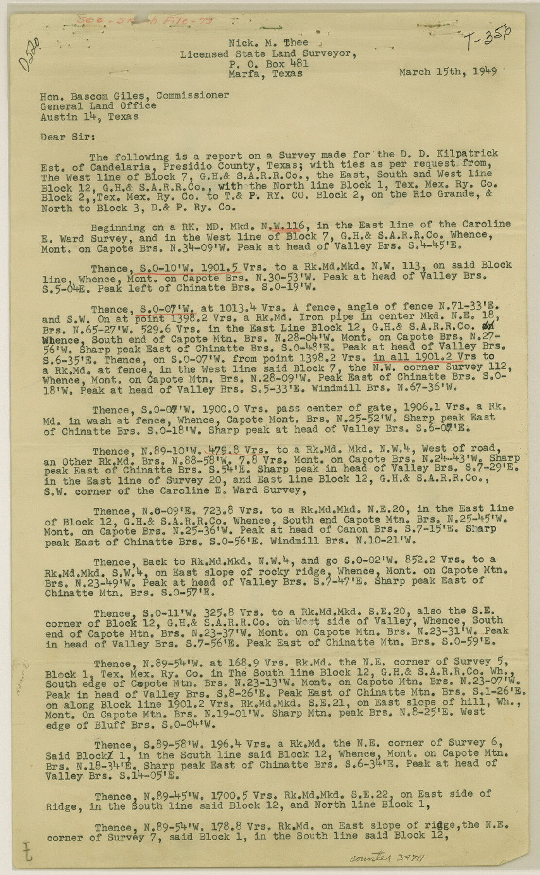
Presidio County Sketch File 82
[Connecting line from northwest corner of 116, Block 7, G. H. & S. A. along north and south Block line 1 Tex. Mex. 12, G. H. & S. A. to Candelaria]
-
Map/Doc
34711
-
Collection
General Map Collection
-
Object Dates
3/15/1949 (Creation Date)
3/25/1949 (File Date)
3/15/1949 (Correspondence Date)
-
People and Organizations
Nick M. Thee (Surveyor/Engineer)
Seay (Surveyor/Engineer)
-
Counties
Presidio
-
Subjects
Surveying Sketch File
-
Height x Width
14.3 x 8.8 inches
36.3 x 22.4 cm
-
Medium
paper, print
-
Features
Candelaria
Rio Grande
Capote Mountain
Chinatte Mountain
Pelone Mountain
Candelaria Post Office
I.B.C. Mountain
Candelaria Road
Capote Creek
Concrete Mountain
Road to Mexico
River Road
Part of: General Map Collection
Hudspeth County Sketch File 2

Print $10.00
- Digital $50.00
Hudspeth County Sketch File 2
1900
Size 13.4 x 8.6 inches
Map/Doc 26884
Parker County Sketch File 15A

Print $20.00
- Digital $50.00
Parker County Sketch File 15A
1875
Size 28.5 x 13.6 inches
Map/Doc 12144
Cottle County Sketch File 16a

Print $64.00
- Digital $50.00
Cottle County Sketch File 16a
1911
Size 11.5 x 8.9 inches
Map/Doc 19522
Newton County Sketch File 5

Print $8.00
- Digital $50.00
Newton County Sketch File 5
Size 8.2 x 12.8 inches
Map/Doc 32368
Uvalde County Working Sketch 5

Print $20.00
- Digital $50.00
Uvalde County Working Sketch 5
1927
Size 13.4 x 18.0 inches
Map/Doc 72075
Fractional Township No. 7 South Range No. 4 West of the Indian Meridian, Indian Territory

Print $20.00
- Digital $50.00
Fractional Township No. 7 South Range No. 4 West of the Indian Meridian, Indian Territory
1898
Size 19.2 x 24.4 inches
Map/Doc 75192
Carson County Sketch File 6

Print $32.00
- Digital $50.00
Carson County Sketch File 6
1928
Size 9.1 x 9.6 inches
Map/Doc 17358
Sketch of a road from Fort Croghan to Phantom Hill, Texas

Print $20.00
- Digital $50.00
Sketch of a road from Fort Croghan to Phantom Hill, Texas
1852
Size 34.7 x 12.2 inches
Map/Doc 2007
Robertson County Working Sketch 11

Print $20.00
- Digital $50.00
Robertson County Working Sketch 11
1984
Size 20.2 x 21.4 inches
Map/Doc 63584
Hutchinson County Rolled Sketch 37A

Print $40.00
- Digital $50.00
Hutchinson County Rolled Sketch 37A
1950
Size 24.7 x 50.5 inches
Map/Doc 9246
Flight Mission No. DQN-5K, Frame 27, Calhoun County

Print $20.00
- Digital $50.00
Flight Mission No. DQN-5K, Frame 27, Calhoun County
1953
Size 18.4 x 22.1 inches
Map/Doc 84378
The Dawn of Humans Peopling of the Americas

The Dawn of Humans Peopling of the Americas
2000
Size 31.3 x 20.5 inches
Map/Doc 96841
You may also like
Webb County Sketch File 55

Print $20.00
- Digital $50.00
Webb County Sketch File 55
1940
Size 20.6 x 12.6 inches
Map/Doc 12650
Flight Mission No. DAH-17M, Frame 65, Orange County

Print $20.00
- Digital $50.00
Flight Mission No. DAH-17M, Frame 65, Orange County
1953
Size 18.8 x 22.5 inches
Map/Doc 86899
Flight Mission No. DAG-17K, Frame 128, Matagorda County

Print $20.00
- Digital $50.00
Flight Mission No. DAG-17K, Frame 128, Matagorda County
1952
Size 18.6 x 22.3 inches
Map/Doc 86348
Hood County Working Sketch 17

Print $40.00
- Digital $50.00
Hood County Working Sketch 17
1987
Size 42.2 x 54.4 inches
Map/Doc 66211
Brazos County Working Sketch 8

Print $20.00
- Digital $50.00
Brazos County Working Sketch 8
1981
Size 18.0 x 13.8 inches
Map/Doc 67483
Section 39 Block Y

Print $20.00
- Digital $50.00
Section 39 Block Y
Size 23.9 x 19.4 inches
Map/Doc 92463
Clay County Sketch File 11a

Print $22.00
- Digital $50.00
Clay County Sketch File 11a
1861
Size 18.3 x 11.9 inches
Map/Doc 11084
Midland County Sketch File 11

Print $20.00
- Digital $50.00
Midland County Sketch File 11
1936
Size 21.6 x 17.5 inches
Map/Doc 12086
Rattlesnake Pasture in Howard and Borden Counties

Print $20.00
- Digital $50.00
Rattlesnake Pasture in Howard and Borden Counties
1908
Size 34.2 x 29.9 inches
Map/Doc 91204
Nueces County Rolled Sketch 124

Print $20.00
- Digital $50.00
Nueces County Rolled Sketch 124
1997
Size 23.7 x 36.8 inches
Map/Doc 7159
Flight Mission No. DQN-7K, Frame 89, Calhoun County

Print $20.00
- Digital $50.00
Flight Mission No. DQN-7K, Frame 89, Calhoun County
1953
Size 18.4 x 22.2 inches
Map/Doc 84480
Newton County Sketch File 42

Print $39.00
- Digital $50.00
Newton County Sketch File 42
1936
Size 13.2 x 8.7 inches
Map/Doc 32425