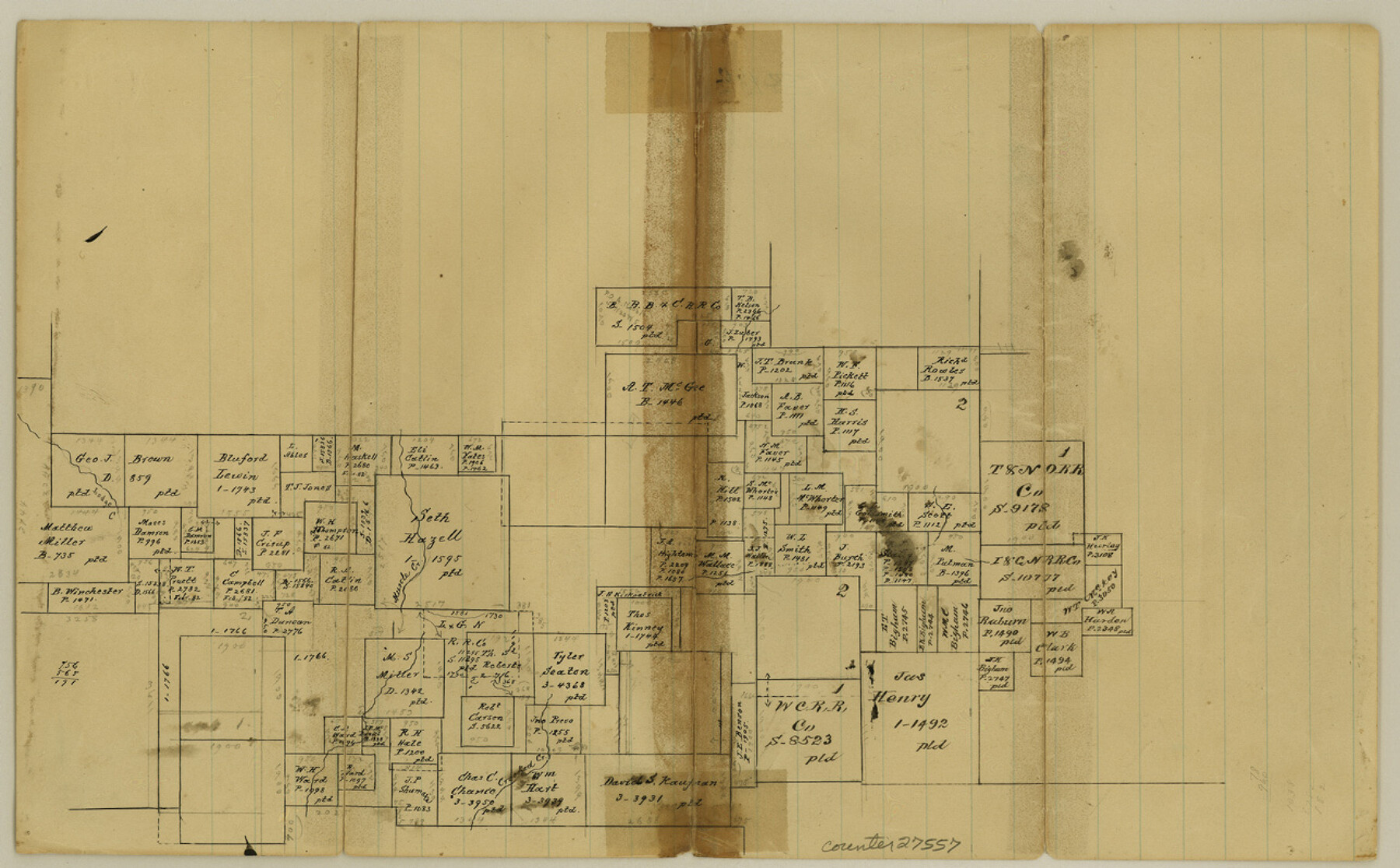
Jack County Sketch File 18b
[Sketch around the Seth Hazell survey]
- 
                          Map/Doc
27557
 - 
                            Collection
General Map Collection
 - 
                            Counties
Jack
 - 
                            Subjects
Surveying Sketch File
 - 
                            Height x Width
8.0 x 12.9 inches
20.3 x 32.8 cm
 - 
                            Medium
paper, manuscript
 - 
                            Features
Muscle Creek
Crooked Creek
Lodge Creek
 
Part of: General Map Collection
            Flight Mission No. DIX-3P, Frame 167, Aransas County


                                            Print $20.00                    
                                             -                         Digital $50.00                                    
                Flight Mission No. DIX-3P, Frame 167, Aransas County
1956
Size 17.8 x 18.0 inches
                                Map/Doc 83773
            
            Grayson County Sketch File 4


                                            Print $4.00                    
                                             -                         Digital $50.00                                    
                Grayson County Sketch File 4
1856
Size 12.5 x 8.2 inches
                                Map/Doc 24462
            
            Hudspeth County Sketch File 52


                                            Print $100.00                    
                                             -                         Digital $50.00                                    
                Hudspeth County Sketch File 52
1983
Size 10.9 x 31.2 inches
                                Map/Doc 11807
            
            Fractional Township No. 8 South Range No. 18 East of the Indian Meridian, Indian Territory


                                            Print $20.00                    
                                             -                         Digital $50.00                                    
                Fractional Township No. 8 South Range No. 18 East of the Indian Meridian, Indian Territory
1897
Size 19.2 x 24.3 inches
                                Map/Doc 75233
            
            Parker County Working Sketch 15


                                            Print $20.00                    
                                             -                         Digital $50.00                                    
                Parker County Working Sketch 15
1982
Map/Doc 71465
            
            Map of Wood County Showing Location of the Texas and Pacific Railway


                                            Print $20.00                    
                                             -                         Digital $50.00                                    
                Map of Wood County Showing Location of the Texas and Pacific Railway
1872
Size 19.1 x 23.8 inches
                                Map/Doc 64135
            
            Flight Mission No. CRC-3R, Frame 53, Chambers County


                                            Print $20.00                    
                                             -                         Digital $50.00                                    
                Flight Mission No. CRC-3R, Frame 53, Chambers County
1956
Size 18.6 x 22.4 inches
                                Map/Doc 84825
            
            Edwards County Working Sketch 16


                                            Print $20.00                    
                                             -                         Digital $50.00                                    
                Edwards County Working Sketch 16
1929
Size 21.5 x 21.5 inches
                                Map/Doc 68892
            
            Kinney County Sketch File 35


                                            Print $6.00                    
                                             -                         Digital $50.00                                    
                Kinney County Sketch File 35
1944
Size 14.2 x 8.7 inches
                                Map/Doc 29185
            
            Hansford County Boundary File 3


                                            Print $10.00                    
                                             -                         Digital $50.00                                    
                Hansford County Boundary File 3
Size 13.6 x 8.7 inches
                                Map/Doc 54270
            
            Hardin County Sketch File 46


                                            Print $8.00                    
                                             -                         Digital $50.00                                    
                Hardin County Sketch File 46
1875
Size 12.8 x 8.4 inches
                                Map/Doc 25196
            You may also like
            Edwards County


                                            Print $20.00                    
                                             -                         Digital $50.00                                    
                Edwards County
1893
Size 26.7 x 30.2 inches
                                Map/Doc 4650
            
            Parker County Sketch File D


                                            Print $4.00                    
                                             -                         Digital $50.00                                    
                Parker County Sketch File D
Size 9.9 x 8.2 inches
                                Map/Doc 33514
            
            [Blocks M13, S1, C3, JK3, and JK]


                                            Print $20.00                    
                                             -                         Digital $50.00                                    
                [Blocks M13, S1, C3, JK3, and JK]
Size 26.9 x 15.4 inches
                                Map/Doc 90700
            
            Crockett County Rolled Sketch 90


                                            Print $20.00                    
                                             -                         Digital $50.00                                    
                Crockett County Rolled Sketch 90
1975
Size 25.4 x 37.3 inches
                                Map/Doc 5631
            
            Hardin County Sketch File 47


                                            Print $4.00                    
                                             -                         Digital $50.00                                    
                Hardin County Sketch File 47
1875
Size 7.2 x 7.2 inches
                                Map/Doc 25200
            
            Cochran and Yoakum Counties, Texas


                                            Print $20.00                    
                                             -                         Digital $50.00                                    
                Cochran and Yoakum Counties, Texas
1945
Size 24.4 x 17.4 inches
                                Map/Doc 92513
            
            [Sketch showing surveys in the north half of Potter County, Blocks 1, 6-T, 25, B-10, B-12, O-18, P and Mc, and H. & T. C., Block 44]


                                            Print $20.00                    
                                             -                         Digital $50.00                                    
                [Sketch showing surveys in the north half of Potter County, Blocks 1, 6-T, 25, B-10, B-12, O-18, P and Mc, and H. & T. C., Block 44]
Size 40.4 x 17.7 inches
                                Map/Doc 91742
            
            Presidio County Rolled Sketch T-3


                                            Print $20.00                    
                                             -                         Digital $50.00                                    
                Presidio County Rolled Sketch T-3
Size 36.6 x 28.9 inches
                                Map/Doc 7417
            
            Martin County


                                            Print $20.00                    
                                             -                         Digital $50.00                                    
                Martin County
1933
Size 38.9 x 34.0 inches
                                Map/Doc 77366
            
            Hansford County Boundary File 3


                                            Print $10.00                    
                                             -                         Digital $50.00                                    
                Hansford County Boundary File 3
Size 13.6 x 8.7 inches
                                Map/Doc 54270
            
            Outer Continental Shelf Leasing Maps (Texas Offshore Operations)


                                            Print $20.00                    
                                             -                         Digital $50.00                                    
                Outer Continental Shelf Leasing Maps (Texas Offshore Operations)
Size 17.2 x 13.7 inches
                                Map/Doc 75842