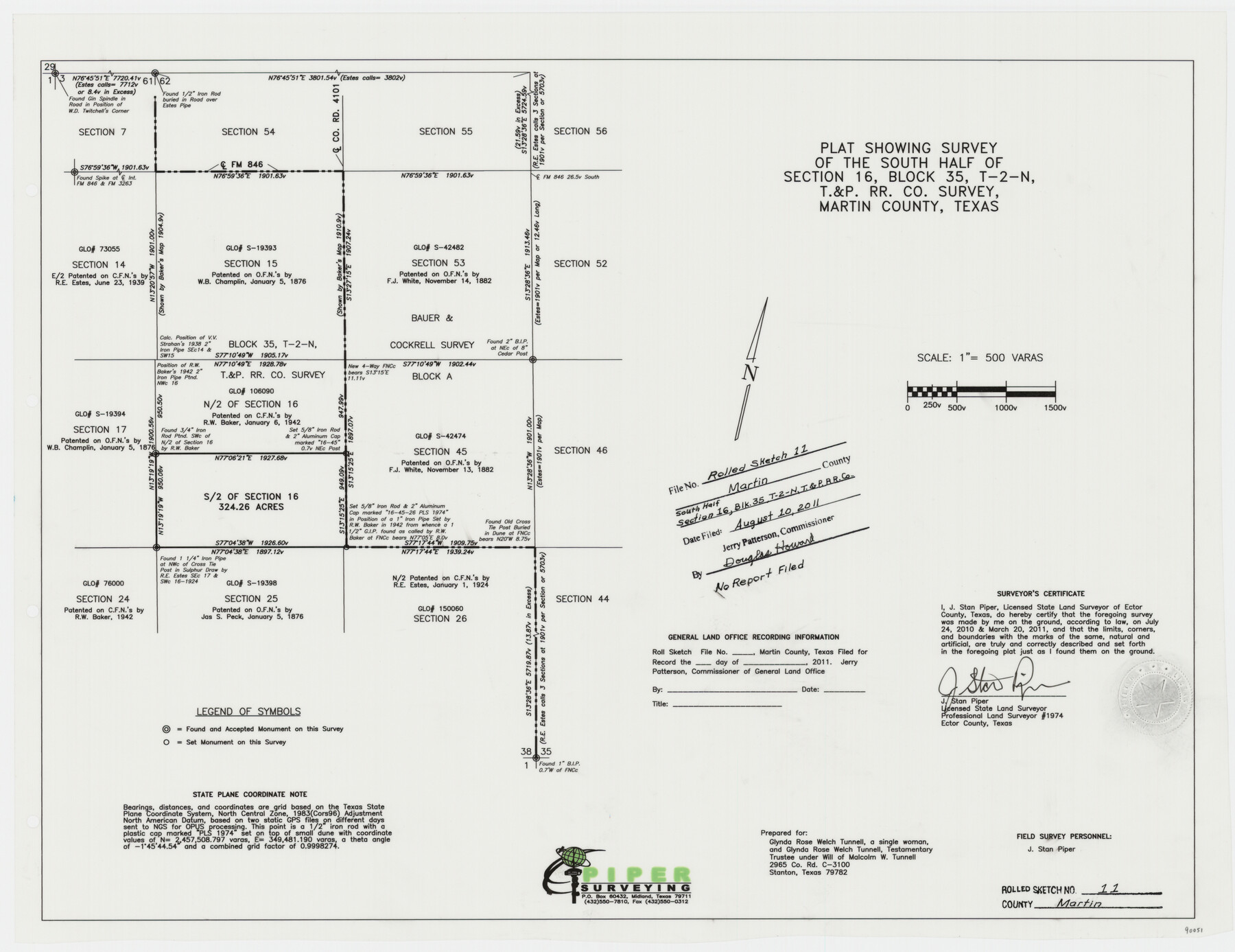
Martin County Rolled Sketch 11
Plat showing survey of the south half of section 16, Block 35, T-2-N, T. & P. R.R. Co. survey, Martin County, Texas
-
Map/Doc
90051
-
Collection
General Map Collection
-
Object Dates
2011/3/20 (Survey Date)
2011/8/10 (File Date)
2010/7/24 (Survey Date)
-
People and Organizations
J. Stan Piper (Surveyor/Engineer)
-
Counties
Martin
-
Subjects
Surveying Rolled Sketch
-
Height x Width
19.3 x 25.0 inches
49.0 x 63.5 cm
-
Medium
mylar, print
-
Scale
1" = 500 varas
Part of: General Map Collection
Map of San Augustine County

Print $20.00
- Digital $50.00
Map of San Augustine County
1841
Size 20.5 x 16.9 inches
Map/Doc 4013
Red River County Working Sketch 80

Print $20.00
- Digital $50.00
Red River County Working Sketch 80
1982
Size 24.1 x 29.3 inches
Map/Doc 72063
Greer County Sketch File 5

Print $8.00
- Digital $50.00
Greer County Sketch File 5
1883
Size 10.0 x 15.6 inches
Map/Doc 24521

McMullen County Working Sketch 30

Print $40.00
- Digital $50.00
McMullen County Working Sketch 30
1957
Size 41.4 x 50.8 inches
Map/Doc 70731

Zavala County Sketch File 33

Print $7.00
- Digital $50.00
Zavala County Sketch File 33
1886
Size 10.9 x 8.3 inches
Map/Doc 41392
Throckmorton County Sketch File 6

Print $27.00
- Digital $50.00
Throckmorton County Sketch File 6
1888
Size 9.0 x 6.9 inches
Map/Doc 38076
Presidio County Working Sketch 134

Print $40.00
- Digital $50.00
Presidio County Working Sketch 134
1989
Size 37.0 x 55.6 inches
Map/Doc 71812
Zavala County Sketch File 9

Print $20.00
- Digital $50.00
Zavala County Sketch File 9
1884
Size 29.1 x 15.9 inches
Map/Doc 12727
Nueces County Rolled Sketch 110

Print $20.00
- Digital $50.00
Nueces County Rolled Sketch 110
1990
Size 24.1 x 37.5 inches
Map/Doc 7117
Concho County Sketch File 30

Print $20.00
- Digital $50.00
Concho County Sketch File 30
1858
Size 13.8 x 20.4 inches
Map/Doc 11156
You may also like
Map of Live Oak County, Texas

Print $20.00
- Digital $50.00
Map of Live Oak County, Texas
1911
Size 28.0 x 20.4 inches
Map/Doc 567
Hall County Sketch File D

Print $8.00
- Digital $50.00
Hall County Sketch File D
1906
Size 14.4 x 8.7 inches
Map/Doc 24792
Map of certain tidal areas in Harris and Galveston Counties showing subdivision thereof for mineral development

Print $20.00
- Digital $50.00
Map of certain tidal areas in Harris and Galveston Counties showing subdivision thereof for mineral development
1938
Size 34.3 x 26.7 inches
Map/Doc 2936
Jones Subdivision of Sections 28 and 32, Block "A' and Section 2, Block "D3"

Print $2.00
- Digital $50.00
Jones Subdivision of Sections 28 and 32, Block "A' and Section 2, Block "D3"
1928
Size 8.7 x 8.7 inches
Map/Doc 92708
Crockett County Working Sketch 88

Print $20.00
- Digital $50.00
Crockett County Working Sketch 88
1976
Size 34.0 x 32.9 inches
Map/Doc 68421
Gulf Coast of the United States, Key West to Rio Grande

Print $20.00
- Digital $50.00
Gulf Coast of the United States, Key West to Rio Grande
1863
Size 27.4 x 18.3 inches
Map/Doc 72666
Camp County, Texas

Print $3.00
- Digital $50.00
Camp County, Texas
1879
Size 9.6 x 16.8 inches
Map/Doc 512
Eastland County Sketch File 22

Print $33.00
- Digital $50.00
Eastland County Sketch File 22
1964
Size 11.0 x 17.0 inches
Map/Doc 21626
[Surveys along the Leon River and Plum Creek]
![69730, [Surveys along the Leon River and Plum Creek], General Map Collection](https://historictexasmaps.com/wmedia_w700/maps/69730.tif.jpg)
Print $2.00
- Digital $50.00
[Surveys along the Leon River and Plum Creek]
1846
Size 9.0 x 14.0 inches
Map/Doc 69730
Tom Green County Sketch File 88

Print $8.00
- Digital $50.00
Tom Green County Sketch File 88
1990
Size 11.5 x 8.9 inches
Map/Doc 38266
Leon County Working Sketch 29

Print $20.00
- Digital $50.00
Leon County Working Sketch 29
1971
Size 25.8 x 33.1 inches
Map/Doc 70428
Carson County Boundary File 6

Print $48.00
- Digital $50.00
Carson County Boundary File 6
Size 12.8 x 8.3 inches
Map/Doc 51151