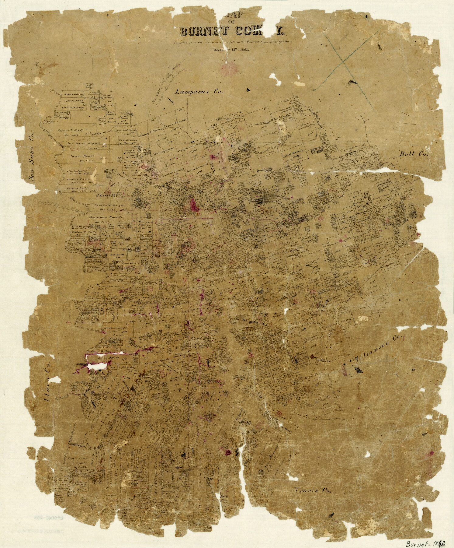
Map of Burnet County
-
Map/Doc
3353
-
Collection
General Map Collection
-
Object Dates
12/18/1862 (Creation Date)
-
People and Organizations
Osw. Dietz (Compiler)
-
Counties
Burnet
-
Subjects
County
-
Height x Width
27.1 x 22.5 inches
68.8 x 57.2 cm
-
Features
Clear Creek
Love Creek
Double Horn Creek
Horseshoe Creek
Slick Rock Creek
Pecan Creek
Sandy Creek
Hamilton Creek
Backbone Creek
Llano River
South Fork of San Gabriel River
Spring Creek
Lampasas River
Torita Peak
Burnet
North Fork of San Gabriel River
Russell Creek
Colorado River
Rocky Creek
Deer Creek
Bachelor Peak
Mesquite Creek
Salt Fork of Lampasas River
Part of: General Map Collection
Henderson County Working Sketch 21

Print $20.00
- Digital $50.00
Henderson County Working Sketch 21
1948
Size 17.1 x 16.2 inches
Map/Doc 66154

Map of the Recognised Line M. EL. P. & P. R. R. from East Line of Bexar Land District to El Paso

Print $40.00
- Digital $50.00
Map of the Recognised Line M. EL. P. & P. R. R. from East Line of Bexar Land District to El Paso
1857
Size 20.0 x 50.4 inches
Map/Doc 85322
Flight Mission No. DAG-22K, Frame 83, Matagorda County

Print $20.00
- Digital $50.00
Flight Mission No. DAG-22K, Frame 83, Matagorda County
1953
Size 18.5 x 18.7 inches
Map/Doc 86467
Fayette County Rolled Sketch 1

Print $20.00
- Digital $50.00
Fayette County Rolled Sketch 1
1981
Size 20.9 x 25.8 inches
Map/Doc 5876
Brazoria County Working Sketch 34

Print $20.00
- Digital $50.00
Brazoria County Working Sketch 34
1981
Size 15.8 x 19.0 inches
Map/Doc 67519
Pecos County Working Sketch 112

Print $40.00
- Digital $50.00
Pecos County Working Sketch 112
Size 48.1 x 37.0 inches
Map/Doc 71585
Hudspeth County Sketch File 42

Print $12.00
- Digital $50.00
Hudspeth County Sketch File 42
1982
Size 14.2 x 8.7 inches
Map/Doc 27016
Zavala County Rolled Sketch 22

Print $20.00
- Digital $50.00
Zavala County Rolled Sketch 22
Size 22.0 x 29.8 inches
Map/Doc 8325
Garza County Working Sketch Graphic Index

Print $20.00
- Digital $50.00
Garza County Working Sketch Graphic Index
1928
Size 46.7 x 36.2 inches
Map/Doc 76552
Knox County Rolled Sketch 16

Print $20.00
- Digital $50.00
Knox County Rolled Sketch 16
1892
Size 29.8 x 32.4 inches
Map/Doc 76029
Henderson County Boundary File 3b

Print $14.00
- Digital $50.00
Henderson County Boundary File 3b
Size 14.4 x 8.9 inches
Map/Doc 54700
You may also like
United States - Gulf Coast - From Latitude 26° 33' to the Rio Grande Texas

Print $20.00
- Digital $50.00
United States - Gulf Coast - From Latitude 26° 33' to the Rio Grande Texas
1918
Size 27.7 x 18.2 inches
Map/Doc 72850
Hardin County Sketch File 53

Print $12.00
- Digital $50.00
Hardin County Sketch File 53
Size 11.4 x 8.8 inches
Map/Doc 25213
[Sketch Showing Blocks in Hansford County, Texas]
![75818, [Sketch Showing Blocks in Hansford County, Texas], Maddox Collection](https://historictexasmaps.com/wmedia_w700/maps/75818.tif.jpg)
Print $20.00
- Digital $50.00
[Sketch Showing Blocks in Hansford County, Texas]
1890
Size 34.3 x 24.6 inches
Map/Doc 75818
Upton County Working Sketch 48

Print $20.00
- Digital $50.00
Upton County Working Sketch 48
1975
Size 29.3 x 24.3 inches
Map/Doc 69544
Polk County Sketch File 16

Print $4.00
- Digital $50.00
Polk County Sketch File 16
1861
Size 7.9 x 11.1 inches
Map/Doc 34161
Roberts County Rolled Sketch 5

Print $20.00
- Digital $50.00
Roberts County Rolled Sketch 5
2015
Size 42.6 x 25.0 inches
Map/Doc 94071
Orange County Sketch File 14a

Print $4.00
- Digital $50.00
Orange County Sketch File 14a
1886
Size 8.1 x 10.2 inches
Map/Doc 33328

Parker County Sketch File 32

Print $6.00
- Digital $50.00
Parker County Sketch File 32
Size 11.0 x 12.2 inches
Map/Doc 33574
Coke County Working Sketch 9

Print $20.00
- Digital $50.00
Coke County Working Sketch 9
1927
Size 23.9 x 30.3 inches
Map/Doc 68046
Hood County Rolled Sketch 3

Print $20.00
- Digital $50.00
Hood County Rolled Sketch 3
1967
Size 33.2 x 36.2 inches
Map/Doc 9179
Brazos River, Ft. Griffin State Park/Mill Cr.-Clear Fork of Brazos River

Print $4.00
- Digital $50.00
Brazos River, Ft. Griffin State Park/Mill Cr.-Clear Fork of Brazos River
1940
Size 27.5 x 20.5 inches
Map/Doc 65291