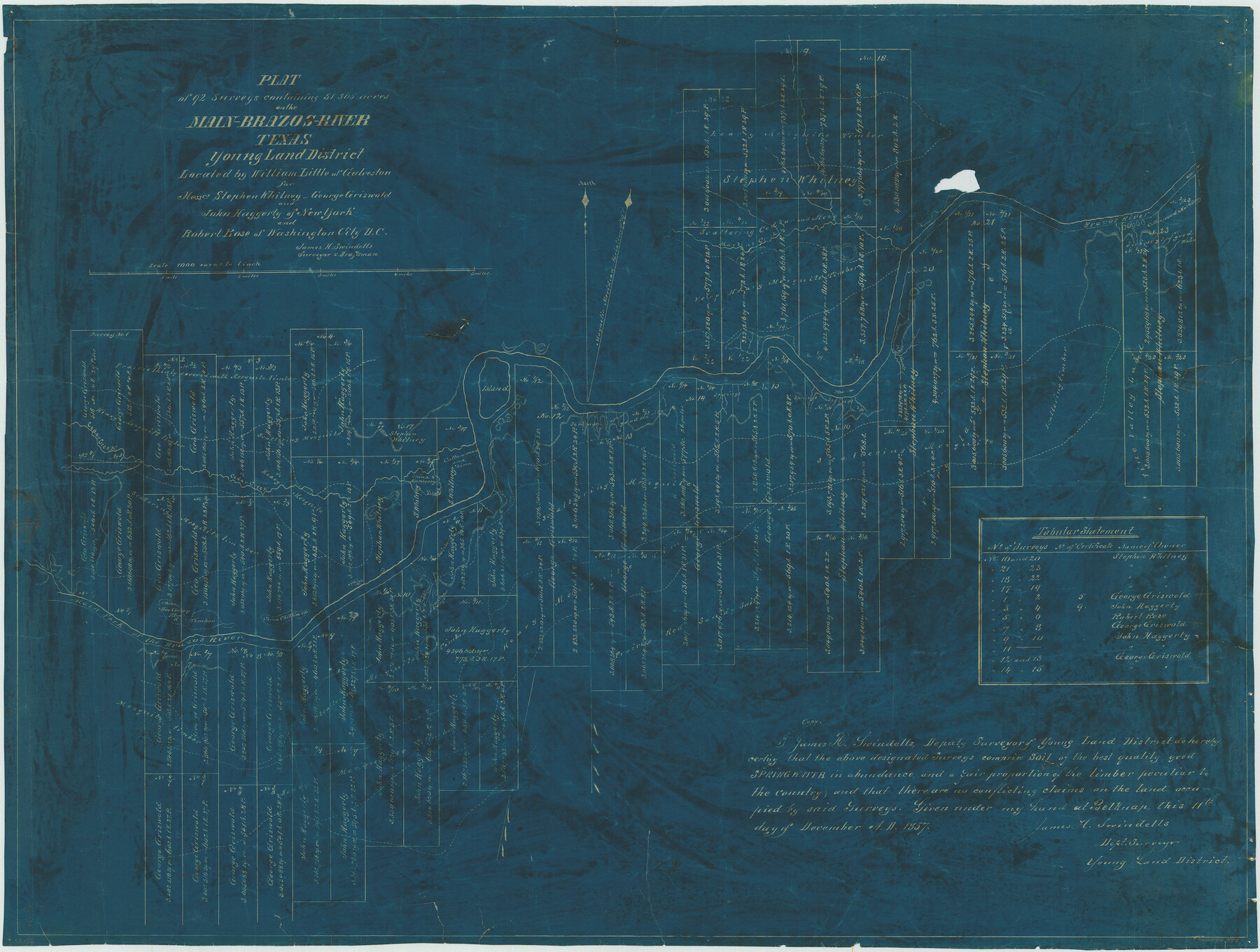
Plat of 92 Surveys Containing 51,365 acres on the Main Brazos River, Texas ,Young Land District
-
Map/Doc
551
-
Collection
Maddox Collection
-
Object Dates
1857/12/11 (Creation Date)
-
People and Organizations
James H. Swindells (Draftsman)
James H. Swindells (Surveyor/Engineer)
-
Counties
Knox
-
Height x Width
23.4 x 31.0 inches
59.4 x 78.7 cm
-
Medium
blueprint/diazo
-
Scale
1000 varas = 1 inch
-
Comments
Located by William Little of Galveston for Messrs. Stephen Whitney-George Griswold and John Haggerty of New York and Robert Rose of Washington City, D.C.
-
Features
Martins Creek
Brazos River
Cedar Creek
Springs of good water
Spring Creek
Sulpher Springs
Main Fork of the Brazos River
Part of: Maddox Collection
Saline Ranch in Mason, Kimble and Menard Counties

Print $20.00
- Digital $50.00
Saline Ranch in Mason, Kimble and Menard Counties
1916
Size 28.3 x 27.2 inches
Map/Doc 75806
Fisher County

Print $20.00
- Digital $50.00
Fisher County
1880
Size 29.4 x 25.3 inches
Map/Doc 75772
[Sketch Showing Blocks in Hansford County, Texas]
![75818, [Sketch Showing Blocks in Hansford County, Texas], Maddox Collection](https://historictexasmaps.com/wmedia_w700/maps/75818.tif.jpg)
Print $20.00
- Digital $50.00
[Sketch Showing Blocks in Hansford County, Texas]
1890
Size 34.3 x 24.6 inches
Map/Doc 75818
New Birmingham, Cherokee County, Texas

Print $20.00
- Digital $50.00
New Birmingham, Cherokee County, Texas
1890
Size 31.0 x 36.2 inches
Map/Doc 451
[San Antonio del Encinal Survey and Surveys West Thereof, Brooks County, Texas]
![10773, [San Antonio del Encinal Survey and Surveys West Thereof, Brooks County, Texas], Maddox Collection](https://historictexasmaps.com/wmedia_w700/maps/10773.tif.jpg)
Print $20.00
- Digital $50.00
[San Antonio del Encinal Survey and Surveys West Thereof, Brooks County, Texas]
Size 18.6 x 24.6 inches
Map/Doc 10773
[Sketch Showing G. H. & H. R.R. Co. Block 3B and A. B. & M. Block M16, Hutchinson County, Texas]
![75813, [Sketch Showing G. H. & H. R.R. Co. Block 3B and A. B. & M. Block M16, Hutchinson County, Texas], Maddox Collection](https://historictexasmaps.com/wmedia_w700/maps/75813.tif.jpg)
Print $20.00
- Digital $50.00
[Sketch Showing G. H. & H. R.R. Co. Block 3B and A. B. & M. Block M16, Hutchinson County, Texas]
Size 20.7 x 21.5 inches
Map/Doc 75813
Plat of Surveys in Hidalgo Co.

Print $20.00
- Digital $50.00
Plat of Surveys in Hidalgo Co.
Size 18.2 x 9.3 inches
Map/Doc 405
[Town Plat of Lamar]
![4462, [Town Plat of Lamar], Maddox Collection](https://historictexasmaps.com/wmedia_w700/maps/4462-1.tif.jpg)
Print $20.00
- Digital $50.00
[Town Plat of Lamar]
Size 19.0 x 25.0 inches
Map/Doc 4462
Map of Harrison County, Texas

Print $20.00
- Digital $50.00
Map of Harrison County, Texas
1879
Size 20.2 x 21.9 inches
Map/Doc 375
Hansford County, Texas

Print $20.00
- Digital $50.00
Hansford County, Texas
1888
Size 22.5 x 17.8 inches
Map/Doc 731
Sketch H, Dickens County, Texas

Print $20.00
- Digital $50.00
Sketch H, Dickens County, Texas
1902
Size 16.0 x 14.3 inches
Map/Doc 4365
Map of Walker County, Texas

Print $20.00
- Digital $50.00
Map of Walker County, Texas
1879
Size 19.9 x 16.6 inches
Map/Doc 655
You may also like

Menard County Working Sketch 11

Print $20.00
- Digital $50.00
Menard County Working Sketch 11
1939
Size 23.1 x 24.9 inches
Map/Doc 70958
Coleman County Sketch File 10

Print $20.00
- Digital $50.00
Coleman County Sketch File 10
1848
Size 28.0 x 13.2 inches
Map/Doc 11119
Ellwood Place, Installment No. 3

Print $20.00
- Digital $50.00
Ellwood Place, Installment No. 3
Size 17.8 x 24.9 inches
Map/Doc 92791
Brown County Working Sketch Graphic Index

Print $20.00
- Digital $50.00
Brown County Working Sketch Graphic Index
1944
Size 47.6 x 37.1 inches
Map/Doc 76480
Zapata County Sketch File 13

Print $4.00
- Digital $50.00
Zapata County Sketch File 13
1930
Size 11.3 x 8.8 inches
Map/Doc 40952
Blanco County Working Sketch 26

Print $40.00
- Digital $50.00
Blanco County Working Sketch 26
1969
Size 52.7 x 38.7 inches
Map/Doc 67386
Culberson County Working Sketch 55

Print $20.00
- Digital $50.00
Culberson County Working Sketch 55
1974
Size 47.1 x 33.7 inches
Map/Doc 68509
Aransas County NRC Article 33.136 Sketch 7

Print $46.00
- Digital $50.00
Aransas County NRC Article 33.136 Sketch 7
2000
Size 11.0 x 8.6 inches
Map/Doc 13563
Reagan County Rolled Sketch 20

Print $20.00
- Digital $50.00
Reagan County Rolled Sketch 20
1948
Size 45.8 x 45.0 inches
Map/Doc 9814
Cameron County Sketch File 7

Print $146.00
- Digital $50.00
Cameron County Sketch File 7
1980
Size 14.3 x 8.7 inches
Map/Doc 17042
Dickens County Rolled Sketch P1

Print $20.00
- Digital $50.00
Dickens County Rolled Sketch P1
1915
Size 40.5 x 36.2 inches
Map/Doc 8783