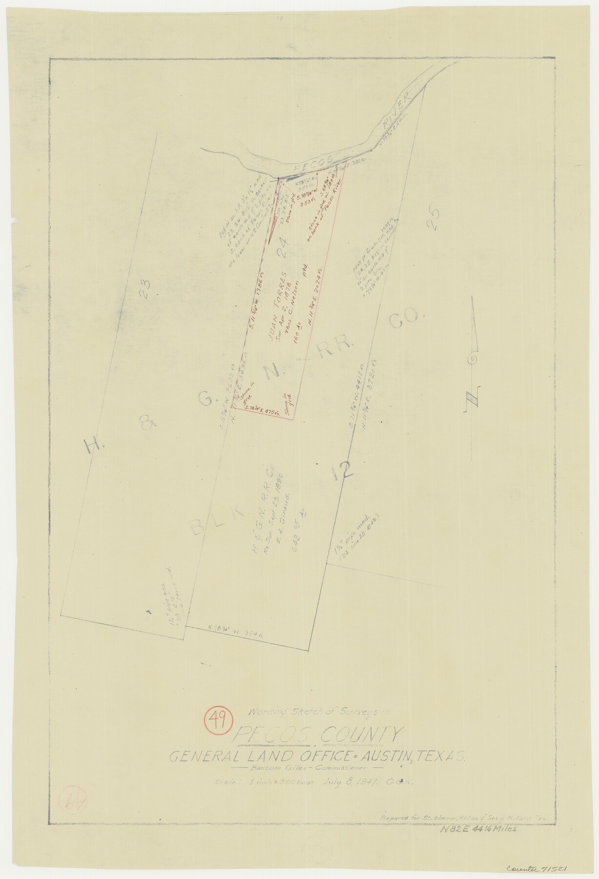
Pecos County Working Sketch 49
-
Map/Doc
71521
-
Collection
General Map Collection
-
Object Dates
7/8/1947 (Creation Date)
-
People and Organizations
Otto G. Kurio (Draftsman)
-
Counties
Pecos
-
Subjects
Surveying Working Sketch
-
Height x Width
22.4 x 15.3 inches
56.9 x 38.9 cm
-
Scale
1" = 300 varas
Part of: General Map Collection
Flight Mission No. CZW-1R, Frame 165, Hardeman County

Print $20.00
- Digital $50.00
Flight Mission No. CZW-1R, Frame 165, Hardeman County
1956
Size 18.7 x 22.4 inches
Map/Doc 85236
Jefferson County Rolled Sketch 62

Print $40.00
- Digital $50.00
Jefferson County Rolled Sketch 62
1974
Size 78.4 x 43.1 inches
Map/Doc 9318
Travis County Sketch File 73

Print $8.00
- Digital $50.00
Travis County Sketch File 73
1848
Size 12.8 x 8.3 inches
Map/Doc 38464
Ellis County Sketch File 1

Print $6.00
- Digital $50.00
Ellis County Sketch File 1
1849
Size 6.5 x 7.9 inches
Map/Doc 21824
Baylor County Working Sketch 2

Print $20.00
- Digital $50.00
Baylor County Working Sketch 2
1919
Size 22.4 x 24.1 inches
Map/Doc 67287
Duval County Sketch File 18

Print $40.00
- Digital $50.00
Duval County Sketch File 18
Size 12.7 x 15.8 inches
Map/Doc 21314
Hunt County Working Sketch 10

Print $20.00
- Digital $50.00
Hunt County Working Sketch 10
1959
Size 31.5 x 42.8 inches
Map/Doc 66357
Ector County Working Sketch Graphic Index - sheet A

Print $20.00
- Digital $50.00
Ector County Working Sketch Graphic Index - sheet A
1943
Size 44.5 x 39.1 inches
Map/Doc 76530
Lampasas County Working Sketch 4

Print $20.00
- Digital $50.00
Lampasas County Working Sketch 4
1941
Size 23.1 x 16.8 inches
Map/Doc 70281
Terrell County Working Sketch 53

Print $20.00
- Digital $50.00
Terrell County Working Sketch 53
Size 13.5 x 17.8 inches
Map/Doc 69802
Harris County Sketch File 3

Print $4.00
- Digital $50.00
Harris County Sketch File 3
Size 7.0 x 6.2 inches
Map/Doc 25334
Copy of Surveyor's Field Book, Morris Browning - In Blocks 7, 5 & 4, I&GNRRCo., Hutchinson and Carson Counties, Texas

Print $2.00
- Digital $50.00
Copy of Surveyor's Field Book, Morris Browning - In Blocks 7, 5 & 4, I&GNRRCo., Hutchinson and Carson Counties, Texas
1888
Size 7.0 x 8.8 inches
Map/Doc 62259
You may also like

Red River County Working Sketch 12

Print $20.00
- Digital $50.00
Red River County Working Sketch 12
Size 17.3 x 20.0 inches
Map/Doc 71995
Anderson County Working Sketch 30

Print $20.00
- Digital $50.00
Anderson County Working Sketch 30
1963
Size 29.8 x 41.6 inches
Map/Doc 67030
[William Steele Survey near Copano Bay]
![2082, [William Steele Survey near Copano Bay], General Map Collection](https://historictexasmaps.com/wmedia_w700/maps/2082.tif.jpg)
Print $20.00
- Digital $50.00
[William Steele Survey near Copano Bay]
1927
Size 26.1 x 18.4 inches
Map/Doc 2082
McCulloch County Working Sketch 15

Print $20.00
- Digital $50.00
McCulloch County Working Sketch 15
1994
Size 33.2 x 34.0 inches
Map/Doc 70690
Duval County Sketch File 52

Print $20.00
- Digital $50.00
Duval County Sketch File 52
1936
Size 21.0 x 28.6 inches
Map/Doc 11402
Johnson County Rolled Sketch 1

Print $20.00
- Digital $50.00
Johnson County Rolled Sketch 1
1941
Size 19.4 x 33.4 inches
Map/Doc 6446
[Sketch focused on Southeast corner of Lubbock County]
![89899, [Sketch focused on Southeast corner of Lubbock County], Twichell Survey Records](https://historictexasmaps.com/wmedia_w700/maps/89899-1.tif.jpg)
Print $20.00
- Digital $50.00
[Sketch focused on Southeast corner of Lubbock County]
Size 42.8 x 36.9 inches
Map/Doc 89899
Val Verde County Working Sketch 59

Print $20.00
- Digital $50.00
Val Verde County Working Sketch 59
1958
Size 38.6 x 35.0 inches
Map/Doc 72194
Fractional Township No. 6 South Range No. 7 West of the Indian Meridian, Indian Territory

Print $20.00
- Digital $50.00
Fractional Township No. 6 South Range No. 7 West of the Indian Meridian, Indian Territory
1898
Size 19.4 x 24.3 inches
Map/Doc 75157
Texas-Oklahoma (Indian Territory) Montague Quadrangle

Print $20.00
- Digital $50.00
Texas-Oklahoma (Indian Territory) Montague Quadrangle
1905
Size 20.4 x 17.0 inches
Map/Doc 75106
[Sketch of Blks. 2, 2B, 3B]
![89638, [Sketch of Blks. 2, 2B, 3B], Twichell Survey Records](https://historictexasmaps.com/wmedia_w700/maps/89638-1.tif.jpg)
Print $20.00
- Digital $50.00
[Sketch of Blks. 2, 2B, 3B]
1918
Size 38.0 x 33.2 inches
Map/Doc 89638