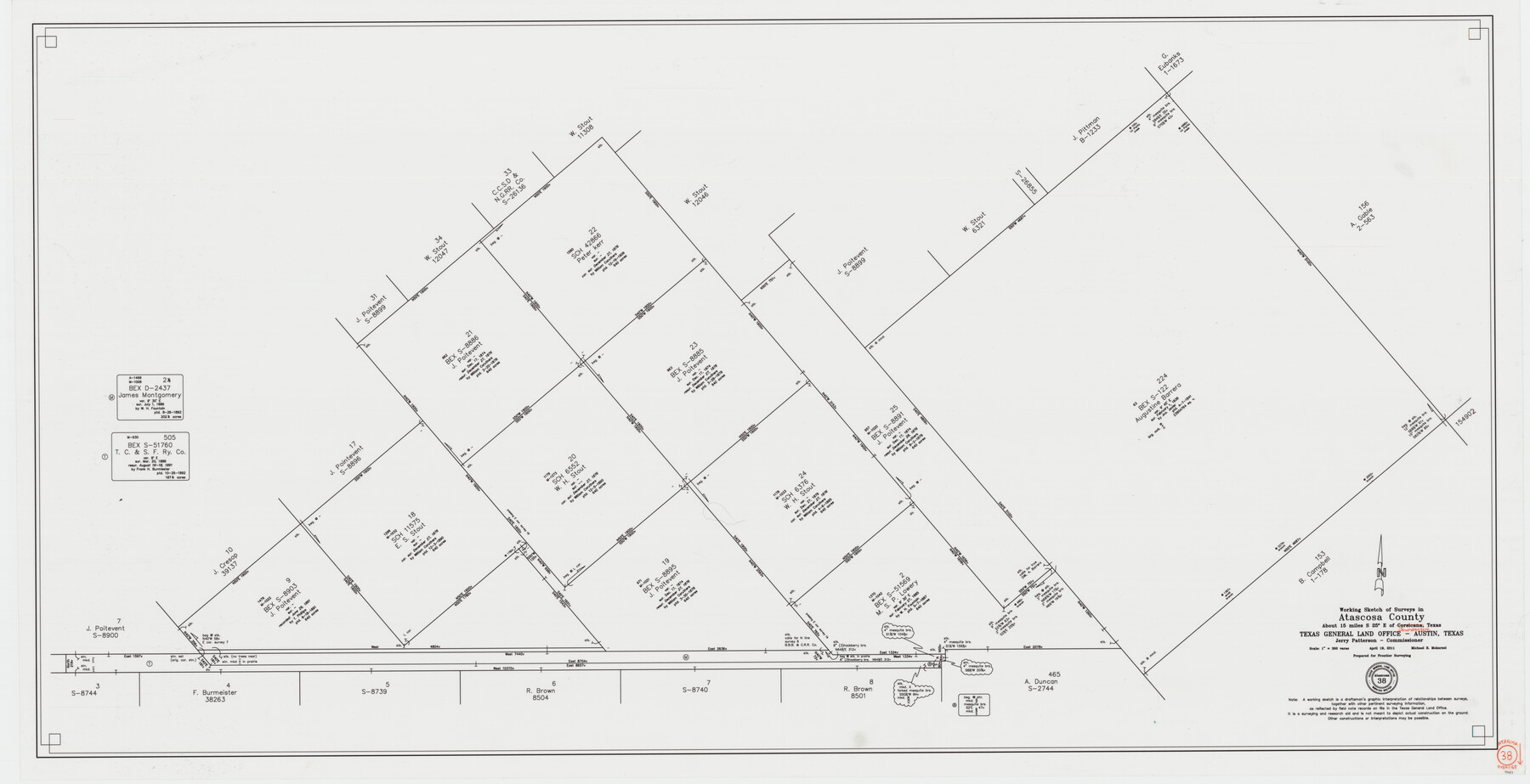
Atascosa County Working Sketch 38
-
Map/Doc
90031
-
Collection
General Map Collection
-
Object Dates
4/19/2011 (Creation Date)
-
People and Organizations
Michael R. Mokarzel (Draftsman)
-
Counties
Atascosa
-
Subjects
Surveying Working Sketch
-
Height x Width
31.1 x 60.6 inches
79.0 x 153.9 cm
-
Scale
1" = 300 varas
Part of: General Map Collection
Harris County Rolled Sketch 88

Print $20.00
- Digital $50.00
Harris County Rolled Sketch 88
1936
Size 34.6 x 22.8 inches
Map/Doc 6124
Starr County Sketch File 31A

Print $20.00
- Digital $50.00
Starr County Sketch File 31A
1936
Size 24.5 x 13.3 inches
Map/Doc 12335
Roberts County Working Sketch 7

Print $20.00
- Digital $50.00
Roberts County Working Sketch 7
1954
Size 25.1 x 33.3 inches
Map/Doc 63533
Jackson County Boundary File 4

Print $4.00
- Digital $50.00
Jackson County Boundary File 4
Size 10.2 x 7.9 inches
Map/Doc 55460
Lavaca County Working Sketch 15

Print $20.00
- Digital $50.00
Lavaca County Working Sketch 15
1965
Size 24.6 x 43.0 inches
Map/Doc 70368
Bandera County Working Sketch 9

Print $20.00
- Digital $50.00
Bandera County Working Sketch 9
1920
Size 15.2 x 17.1 inches
Map/Doc 67602
Roberts County Rolled Sketch 3

Print $40.00
- Digital $50.00
Roberts County Rolled Sketch 3
Size 37.7 x 48.9 inches
Map/Doc 8359
Flight Mission No. DCL-7C, Frame 116, Kenedy County

Print $20.00
- Digital $50.00
Flight Mission No. DCL-7C, Frame 116, Kenedy County
1943
Size 18.6 x 22.4 inches
Map/Doc 86081
McCulloch County Working Sketch Graphic Index

Print $20.00
- Digital $50.00
McCulloch County Working Sketch Graphic Index
1949
Size 47.3 x 37.4 inches
Map/Doc 76636
Terrell County Working Sketch 19

Print $20.00
- Digital $50.00
Terrell County Working Sketch 19
1932
Size 18.6 x 25.6 inches
Map/Doc 69801
Flight Mission No. BQY-4M, Frame 125, Harris County

Print $20.00
- Digital $50.00
Flight Mission No. BQY-4M, Frame 125, Harris County
1953
Size 18.6 x 22.5 inches
Map/Doc 85293
Galveston County Rolled Sketch 37

Print $20.00
- Digital $50.00
Galveston County Rolled Sketch 37
Size 26.8 x 16.5 inches
Map/Doc 5971
You may also like
Brewster County Working Sketch 21

Print $20.00
- Digital $50.00
Brewster County Working Sketch 21
1937
Size 28.9 x 32.7 inches
Map/Doc 67555
Hutchinson County Working Sketch 31

Print $20.00
- Digital $50.00
Hutchinson County Working Sketch 31
1978
Size 27.0 x 22.2 inches
Map/Doc 66391
Harris County NRC Article 33.136 Sketch 14

Print $50.00
- Digital $50.00
Harris County NRC Article 33.136 Sketch 14
Size 24.0 x 36.0 inches
Map/Doc 94816
Stonewall County Working Sketch 6

Print $20.00
- Digital $50.00
Stonewall County Working Sketch 6
1949
Size 16.5 x 30.1 inches
Map/Doc 62313
Terrell County Sketch File 24a

Print $20.00
- Digital $50.00
Terrell County Sketch File 24a
1932
Size 30.4 x 42.2 inches
Map/Doc 10388
Sutton County Working Sketch 63

Print $20.00
- Digital $50.00
Sutton County Working Sketch 63
1961
Size 26.0 x 29.9 inches
Map/Doc 62406
Irrigation in West Texas - the Pecos and Toyah Valleys

Irrigation in West Texas - the Pecos and Toyah Valleys
1912
Size 9.3 x 4.5 inches
Map/Doc 97072
Edwards County Working Sketch 27

Print $20.00
- Digital $50.00
Edwards County Working Sketch 27
1944
Size 27.7 x 23.9 inches
Map/Doc 68903
Brooks County Rolled Sketch 26

Print $20.00
- Digital $50.00
Brooks County Rolled Sketch 26
1945
Size 33.7 x 43.3 inches
Map/Doc 8539
Galveston County Sketch File 21

Print $4.00
- Digital $50.00
Galveston County Sketch File 21
1838
Size 13.3 x 8.3 inches
Map/Doc 23392
Denton County Rolled Sketch 7

Print $20.00
- Digital $50.00
Denton County Rolled Sketch 7
2007
Size 24.5 x 19.3 inches
Map/Doc 87941
Live Oak County Sketch File 4

Print $20.00
- Digital $50.00
Live Oak County Sketch File 4
1858
Size 16.3 x 19.2 inches
Map/Doc 12006