Anderson County Sketch File 23
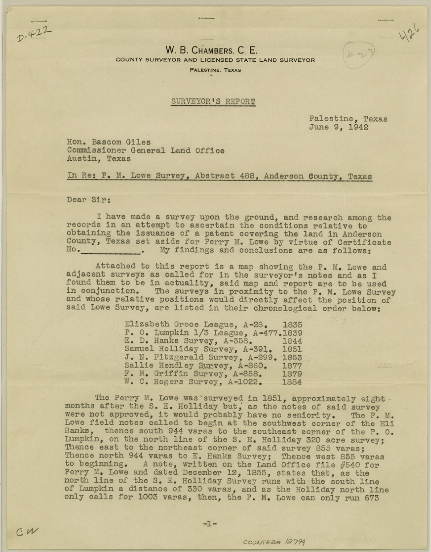
Surveyor's report regarding P.M. Lowe survey, abstract 488, Anderson County, Texas
-
Map/Doc
12794
-
Collection
General Map Collection
-
Object Dates
1942/6/9 (Creation Date)
1942/6/15 (File Date)
-
People and Organizations
W.B. Chambers (Surveyor/Engineer)
-
Counties
Anderson
-
Subjects
Surveying Sketch File
-
Height x Width
11.2 x 8.7 inches
28.4 x 22.1 cm
-
Medium
paper, print
-
Comments
See Anderson County Rolled Sketch 8 (77154) for plat
Related maps
Anderson County Rolled Sketch 8

Print $20.00
- Digital $50.00
Anderson County Rolled Sketch 8
Size 34.8 x 23.9 inches
Map/Doc 77154
Part of: General Map Collection
Texas Intracoastal Waterway - Stover Point to Port Brownsville including Brazos Santiago
Print $20.00
- Digital $50.00
Texas Intracoastal Waterway - Stover Point to Port Brownsville including Brazos Santiago
1962
Size 27.8 x 38.9 inches
Map/Doc 73520
Hudspeth County Working Sketch 57

Print $20.00
- Digital $50.00
Hudspeth County Working Sketch 57
1992
Size 9.6 x 26.5 inches
Map/Doc 66342
Harris County Rolled Sketch WB

Print $20.00
- Digital $50.00
Harris County Rolled Sketch WB
1916
Size 15.5 x 21.1 inches
Map/Doc 6147
Blanco County Rolled Sketch 11

Print $6.00
- Digital $50.00
Blanco County Rolled Sketch 11
Size 33.2 x 27.8 inches
Map/Doc 5147
Lavaca County Sketch File 5

Print $4.00
- Digital $50.00
Lavaca County Sketch File 5
1858
Size 8.2 x 10.1 inches
Map/Doc 29639
Concho County Rolled Sketch 15

Print $40.00
- Digital $50.00
Concho County Rolled Sketch 15
1959
Size 48.3 x 39.5 inches
Map/Doc 8660
Shelby County Working Sketch 11

Print $20.00
- Digital $50.00
Shelby County Working Sketch 11
1945
Size 32.2 x 43.2 inches
Map/Doc 63864
Hutchinson County Sketch File 27

Print $20.00
- Digital $50.00
Hutchinson County Sketch File 27
Size 21.0 x 24.9 inches
Map/Doc 11817
Packery Channel

Print $20.00
- Digital $50.00
Packery Channel
1954
Size 16.7 x 19.9 inches
Map/Doc 3002
Flight Mission No. CRK-5P, Frame 160, Refugio County

Print $20.00
- Digital $50.00
Flight Mission No. CRK-5P, Frame 160, Refugio County
1956
Size 18.6 x 22.4 inches
Map/Doc 86941
Schleicher County Sketch File 36

Print $20.00
- Digital $50.00
Schleicher County Sketch File 36
1951
Size 15.2 x 21.7 inches
Map/Doc 12309
Blanco County Sketch File 30

Print $5.00
- Digital $50.00
Blanco County Sketch File 30
Size 9.1 x 10.6 inches
Map/Doc 14627
You may also like
Concho, San Saba & Llano Valley Railway, Sterling City Branch, Texas. Right of Way and Track Map

Print $40.00
- Digital $50.00
Concho, San Saba & Llano Valley Railway, Sterling City Branch, Texas. Right of Way and Track Map
1910
Size 18.3 x 59.7 inches
Map/Doc 64439
General Highway Map. Detail of Cities and Towns in Grimes County, Texas

Print $20.00
General Highway Map. Detail of Cities and Towns in Grimes County, Texas
1961
Size 18.2 x 24.8 inches
Map/Doc 79491
Garza County Sketch File J

Print $20.00
- Digital $50.00
Garza County Sketch File J
1911
Size 26.5 x 7.5 inches
Map/Doc 11555
The Judicial District/County of Smith. Abolished, Spring 1842

Print $20.00
The Judicial District/County of Smith. Abolished, Spring 1842
2020
Size 19.6 x 21.7 inches
Map/Doc 96347
Galveston County Sketch File 13

Print $20.00
- Digital $50.00
Galveston County Sketch File 13
Size 16.2 x 12.5 inches
Map/Doc 11530
Cameron County Rolled Sketch Z8

Print $20.00
- Digital $50.00
Cameron County Rolled Sketch Z8
1937
Size 30.3 x 34.5 inches
Map/Doc 5406
Kimble County Working Sketch 46

Print $20.00
- Digital $50.00
Kimble County Working Sketch 46
1951
Size 29.3 x 18.9 inches
Map/Doc 70114
Bosque County Sketch File 9

Print $6.00
- Digital $50.00
Bosque County Sketch File 9
1859
Size 4.3 x 4.7 inches
Map/Doc 14754
Flight Mission No. DIX-3P, Frame 59, Aransas County

Print $20.00
- Digital $50.00
Flight Mission No. DIX-3P, Frame 59, Aransas County
1956
Size 17.6 x 21.1 inches
Map/Doc 83761
Brazoria County State Real Property Sketch 1

Print $20.00
- Digital $50.00
Brazoria County State Real Property Sketch 1
1997
Size 24.4 x 34.8 inches
Map/Doc 80127
Fisher County Rolled Sketch 7

Print $20.00
- Digital $50.00
Fisher County Rolled Sketch 7
1873
Size 47.1 x 43.5 inches
Map/Doc 8891
Hockley County Sketch File M

Print $20.00
- Digital $50.00
Hockley County Sketch File M
Size 22.2 x 25.8 inches
Map/Doc 11777