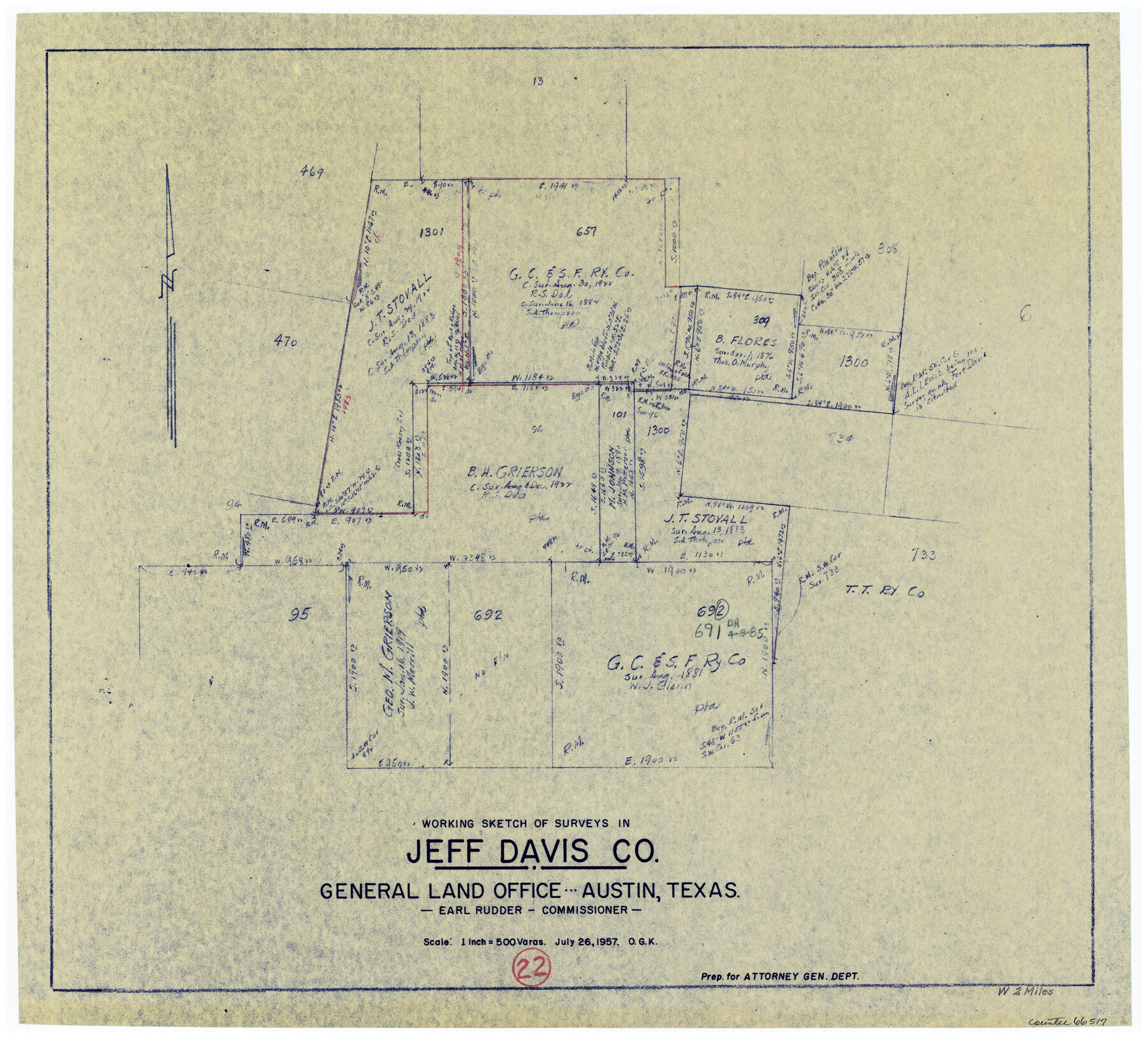
Jeff Davis County Working Sketch 22
-
Map/Doc
66517
-
Collection
General Map Collection
-
Object Dates
7/26/1957 (Creation Date)
-
People and Organizations
Otto G. Kurio (Draftsman)
-
Counties
Jeff Davis
-
Subjects
Surveying Working Sketch
-
Height x Width
18.9 x 20.9 inches
48.0 x 53.1 cm
-
Scale
1" = 500 varas
Part of: General Map Collection
Stephens County Working Sketch 28

Print $20.00
- Digital $50.00
Stephens County Working Sketch 28
1976
Size 38.4 x 31.8 inches
Map/Doc 63971
Pecos County Working Sketch 89

Print $20.00
- Digital $50.00
Pecos County Working Sketch 89
1964
Size 46.5 x 34.2 inches
Map/Doc 78216
Young County Sketch File 5

Print $40.00
- Digital $50.00
Young County Sketch File 5
1855
Size 12.8 x 15.6 inches
Map/Doc 49662
Runnels County Sketch File 3

Print $4.00
Runnels County Sketch File 3
1871
Size 13.0 x 8.1 inches
Map/Doc 35432
Bowie County Sketch File 7a

Print $30.00
- Digital $50.00
Bowie County Sketch File 7a
1927
Size 11.2 x 8.7 inches
Map/Doc 14854
Flight Mission No. BRE-4P, Frame 167, Nueces County

Print $20.00
- Digital $50.00
Flight Mission No. BRE-4P, Frame 167, Nueces County
1956
Size 18.6 x 22.5 inches
Map/Doc 86830
Clay County Working Sketch 12

Print $20.00
- Digital $50.00
Clay County Working Sketch 12
1955
Size 30.6 x 39.4 inches
Map/Doc 68035
Matagorda County Working Sketch 19

Print $20.00
- Digital $50.00
Matagorda County Working Sketch 19
1961
Size 31.7 x 42.3 inches
Map/Doc 70877
![94181, San Antonio [Recto], General Map Collection](https://historictexasmaps.com/wmedia_w700/maps/94181.tif.jpg)
Collin County Boundary File 18b

Print $24.00
- Digital $50.00
Collin County Boundary File 18b
Size 12.7 x 8.1 inches
Map/Doc 51721
Colorado County Sketch File 1

Print $40.00
- Digital $50.00
Colorado County Sketch File 1
1848
Size 13.0 x 16.1 inches
Map/Doc 18909
Hemphill County Working Sketch 34

Print $40.00
- Digital $50.00
Hemphill County Working Sketch 34
1976
Size 33.9 x 64.2 inches
Map/Doc 66129
You may also like
Andrews County Boundary File 5

Print $40.00
- Digital $50.00
Andrews County Boundary File 5
Size 29.8 x 19.6 inches
Map/Doc 49723
Nueces County Sketch File 62

Print $4.00
- Digital $50.00
Nueces County Sketch File 62
1936
Size 8.6 x 14.3 inches
Map/Doc 32971
[Sketch for Mineral Application 16700 - Pecos River Bed]
![2810, [Sketch for Mineral Application 16700 - Pecos River Bed], General Map Collection](https://historictexasmaps.com/wmedia_w700/maps/2810.tif.jpg)
Print $20.00
- Digital $50.00
[Sketch for Mineral Application 16700 - Pecos River Bed]
1927
Size 17.0 x 36.1 inches
Map/Doc 2810
Coast of Texas from Vicinity of Bolivar Point to Rollover Station

Print $40.00
- Digital $50.00
Coast of Texas from Vicinity of Bolivar Point to Rollover Station
1886
Size 32.5 x 54.0 inches
Map/Doc 69920
Hall County Sketch File 9

Print $12.00
- Digital $50.00
Hall County Sketch File 9
Size 14.3 x 8.9 inches
Map/Doc 24802
Collingsworth County Sketch File 10

Print $4.00
- Digital $50.00
Collingsworth County Sketch File 10
1892
Size 11.3 x 9.0 inches
Map/Doc 18891
Erath County Rolled Sketch 3

Print $20.00
- Digital $50.00
Erath County Rolled Sketch 3
1982
Size 22.6 x 27.9 inches
Map/Doc 5864
Cameron County Rolled Sketch 28C

Print $20.00
- Digital $50.00
Cameron County Rolled Sketch 28C
Size 20.3 x 16.3 inches
Map/Doc 5393
Flight Mission No. BRE-1P, Frame 148, Nueces County

Print $20.00
- Digital $50.00
Flight Mission No. BRE-1P, Frame 148, Nueces County
1956
Size 18.6 x 22.7 inches
Map/Doc 86708
Bexar County Sketch File 34

Print $23.00
- Digital $50.00
Bexar County Sketch File 34
1872
Size 12.2 x 12.5 inches
Map/Doc 14498
Hudspeth County Working Sketch 7

Print $40.00
- Digital $50.00
Hudspeth County Working Sketch 7
1935
Size 92.4 x 33.6 inches
Map/Doc 66288
Galveston County NRC Article 33.136 Sketch 59

Print $24.00
- Digital $50.00
Galveston County NRC Article 33.136 Sketch 59
2008
Size 11.5 x 17.0 inches
Map/Doc 94606