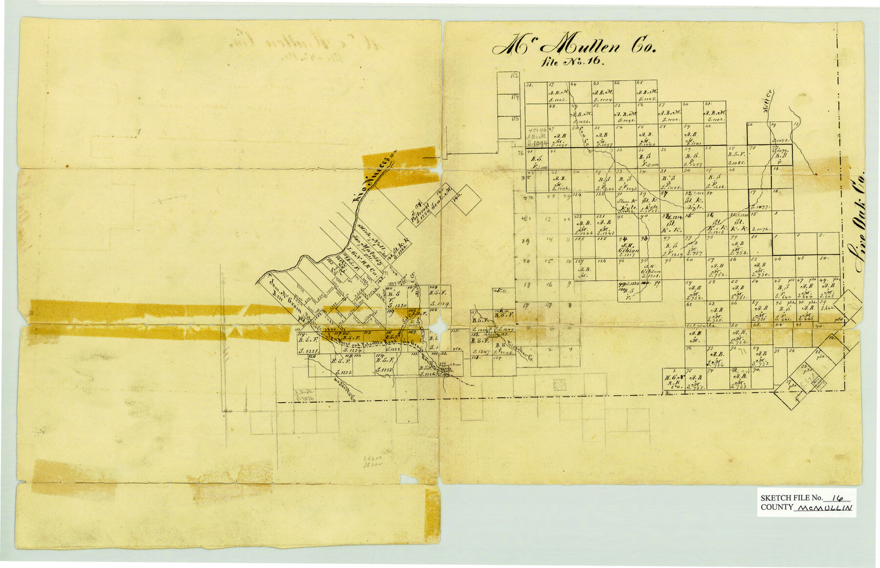
McMullen County Sketch File 16
Office Sketch[es] on Nueces River, McMullen County, Texas
-
Map/Doc
31365
-
Collection
General Map Collection
-
Object Dates
1876 (Creation Date)
-
Counties
McMullen
-
Subjects
Surveying Sketch File
-
Height x Width
5.3 x 8.3 inches
13.5 x 21.1 cm
-
Medium
paper, manuscript
-
Features
Rio Nueces
Cow Creek
Hill Creek
Piscachar Creek
San Diego and Palo Alto road via Gray's Ranches
Potrillo Creek
San Jarita Creek
Part of: General Map Collection
Flight Mission No. CUG-1P, Frame 104, Kleberg County

Print $20.00
- Digital $50.00
Flight Mission No. CUG-1P, Frame 104, Kleberg County
1956
Size 18.5 x 21.1 inches
Map/Doc 86154
Calhoun County Rolled Sketch 30

Print $20.00
- Digital $50.00
Calhoun County Rolled Sketch 30
1974
Size 18.6 x 27.2 inches
Map/Doc 5497
[Bastrop District]
![83518, [Bastrop District], General Map Collection](https://historictexasmaps.com/wmedia_w700/maps/83518-1.tif.jpg)
Print $20.00
- Digital $50.00
[Bastrop District]
1838
Size 19.5 x 44.2 inches
Map/Doc 83518
Reagan County Working Sketch 34

Print $40.00
- Digital $50.00
Reagan County Working Sketch 34
1965
Size 29.7 x 48.3 inches
Map/Doc 71876
Caldwell County Rolled Sketch 1

Print $20.00
- Digital $50.00
Caldwell County Rolled Sketch 1
1953
Size 20.2 x 30.4 inches
Map/Doc 10673
Gaines County Boundary File 2

Print $42.00
- Digital $50.00
Gaines County Boundary File 2
Size 11.5 x 52.3 inches
Map/Doc 53652
Coke County Rolled Sketch 12

Print $20.00
- Digital $50.00
Coke County Rolled Sketch 12
1949
Size 32.7 x 38.8 inches
Map/Doc 8626

Cass County Rolled Sketch 1

Print $20.00
- Digital $50.00
Cass County Rolled Sketch 1
1945
Size 22.1 x 23.7 inches
Map/Doc 5408
Reeves County Sketch File 15

Print $28.00
- Digital $50.00
Reeves County Sketch File 15
1879
Size 13.1 x 8.2 inches
Map/Doc 35194
Flight Mission No. DCL-7C, Frame 46, Kenedy County

Print $20.00
- Digital $50.00
Flight Mission No. DCL-7C, Frame 46, Kenedy County
1943
Size 15.4 x 15.3 inches
Map/Doc 86034
Starr County Sketch File 12

Print $20.00
- Digital $50.00
Starr County Sketch File 12
1886
Size 16.2 x 23.7 inches
Map/Doc 12328
You may also like
Wood County Working Sketch 6

Print $20.00
- Digital $50.00
Wood County Working Sketch 6
1941
Size 29.9 x 17.5 inches
Map/Doc 62006
Gaines County

Print $40.00
- Digital $50.00
Gaines County
1956
Size 45.1 x 56.6 inches
Map/Doc 95504

Map of Kinney County

Print $20.00
- Digital $50.00
Map of Kinney County
1876
Size 24.8 x 37.8 inches
Map/Doc 3776
Flight Mission No. CRC-2R, Frame 120, Chambers County

Print $20.00
- Digital $50.00
Flight Mission No. CRC-2R, Frame 120, Chambers County
1956
Size 18.5 x 22.3 inches
Map/Doc 84744
Harris County Historic Topographic 27

Print $20.00
- Digital $50.00
Harris County Historic Topographic 27
1915
Size 19.8 x 23.5 inches
Map/Doc 65838
La Salle County Sketch File 14

Print $4.00
- Digital $50.00
La Salle County Sketch File 14
Size 6.4 x 6.7 inches
Map/Doc 29483
Tarrant County Sketch File 32

Print $16.00
- Digital $50.00
Tarrant County Sketch File 32
1946
Size 11.3 x 8.8 inches
Map/Doc 37751
'The Cradle of Texas' - San Augustine

Print $20.00
- Digital $50.00
'The Cradle of Texas' - San Augustine
Size 19.3 x 25.3 inches
Map/Doc 94441

Sterling County Working Sketch 6

Print $40.00
- Digital $50.00
Sterling County Working Sketch 6
1955
Size 38.1 x 121.6 inches
Map/Doc 63988
Smith County Working Sketch 17

Print $20.00
- Digital $50.00
Smith County Working Sketch 17
1994
Size 24.6 x 24.2 inches
Map/Doc 63902