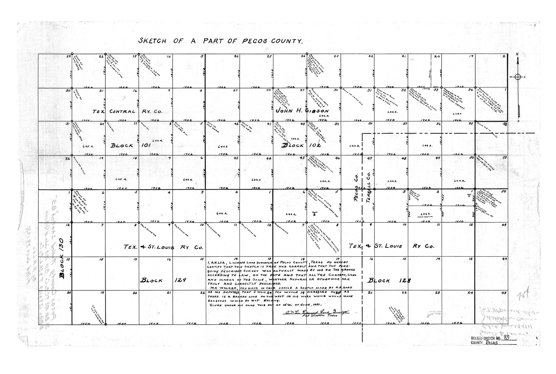
Pecos County Rolled Sketch 83
Sketch of a part of Pecos County
-
Map/Doc
7242
-
Collection
General Map Collection
-
Object Dates
1931 (File Date)
1931/6/15 (Creation Date)
-
People and Organizations
A.N. Lea (Surveyor/Engineer)
-
Counties
Pecos
-
Subjects
Surveying Rolled Sketch
-
Height x Width
17.6 x 26.2 inches
44.7 x 66.5 cm
Part of: General Map Collection
El Paso County Working Sketch 54

Print $20.00
- Digital $50.00
El Paso County Working Sketch 54
1992
Size 31.5 x 29.0 inches
Map/Doc 69076
Presidio County Working Sketch 147

Print $20.00
- Digital $50.00
Presidio County Working Sketch 147
Size 24.5 x 43.1 inches
Map/Doc 71825
A map of Lewis and Clark's track across the western portion of North America from the Mississippi to the Pacific Ocean, by Order of the executive of the United States in 1804, 5, & 6

Print $20.00
- Digital $50.00
A map of Lewis and Clark's track across the western portion of North America from the Mississippi to the Pacific Ocean, by Order of the executive of the United States in 1804, 5, & 6
1814
Size 13.3 x 27.9 inches
Map/Doc 97412
Current Miscellaneous File 83

Print $2.00
- Digital $50.00
Current Miscellaneous File 83
1936
Size 8.3 x 10.6 inches
Map/Doc 74226
Flight Mission No. BRE-1P, Frame 67, Nueces County

Print $20.00
- Digital $50.00
Flight Mission No. BRE-1P, Frame 67, Nueces County
1956
Size 18.7 x 22.4 inches
Map/Doc 86649
Llano County Working Sketch 6

Print $20.00
- Digital $50.00
Llano County Working Sketch 6
1961
Size 15.8 x 20.8 inches
Map/Doc 70624
Zavala County Sketch File 14

Print $26.00
- Digital $50.00
Zavala County Sketch File 14
1887
Size 14.4 x 8.7 inches
Map/Doc 41308
Schleicher County Rolled Sketch 8

Print $20.00
- Digital $50.00
Schleicher County Rolled Sketch 8
Size 27.8 x 29.0 inches
Map/Doc 7750
Duval County Working Sketch 53

Print $20.00
- Digital $50.00
Duval County Working Sketch 53
1948
Size 34.7 x 37.5 inches
Map/Doc 68777
Refugio County Sketch File 22

Print $20.00
- Digital $50.00
Refugio County Sketch File 22
Size 16.2 x 22.3 inches
Map/Doc 12249
Wichita County Working Sketch 20

Print $20.00
- Digital $50.00
Wichita County Working Sketch 20
1950
Size 33.2 x 23.0 inches
Map/Doc 72530
Childress County Working Sketch 4

Print $20.00
- Digital $50.00
Childress County Working Sketch 4
1939
Size 43.4 x 14.5 inches
Map/Doc 68020
You may also like
General Highway Map, Nueces County, Texas

Print $20.00
General Highway Map, Nueces County, Texas
1961
Size 24.9 x 18.4 inches
Map/Doc 79615
9th Street & Ave. A. Galveston, Texas showing beginning of jetty right of way, and seawall extension track

Print $20.00
- Digital $50.00
9th Street & Ave. A. Galveston, Texas showing beginning of jetty right of way, and seawall extension track
1920
Size 21.3 x 33.6 inches
Map/Doc 73630
Tom Green County Sketch File 66

Print $22.00
- Digital $50.00
Tom Green County Sketch File 66
1929
Size 16.8 x 14.6 inches
Map/Doc 38236
Brewster County Rolled Sketch 86

Print $20.00
- Digital $50.00
Brewster County Rolled Sketch 86
1940
Size 16.1 x 26.4 inches
Map/Doc 5247


Irion County Rolled Sketch 20

Print $20.00
- Digital $50.00
Irion County Rolled Sketch 20
1936
Size 26.3 x 42.7 inches
Map/Doc 6329
San Jacinto County Boundary File 1

Print $6.00
- Digital $50.00
San Jacinto County Boundary File 1
Size 9.6 x 8.4 inches
Map/Doc 58548
[Part of Eastern Texas RR. Co. Block 1]
![91921, [Part of Eastern Texas RR. Co. Block 1], Twichell Survey Records](https://historictexasmaps.com/wmedia_w700/maps/91921-1.tif.jpg)
Print $20.00
- Digital $50.00
[Part of Eastern Texas RR. Co. Block 1]
Size 23.9 x 43.1 inches
Map/Doc 91921
Jefferson County Sketch File 52

Print $2.00
- Digital $50.00
Jefferson County Sketch File 52
1985
Size 9.1 x 14.4 inches
Map/Doc 28254
Newton County Working Sketch 36

Print $20.00
- Digital $50.00
Newton County Working Sketch 36
1960
Size 29.9 x 39.1 inches
Map/Doc 71282
Kaufman County Sketch File 15

Print $26.00
- Digital $50.00
Kaufman County Sketch File 15
Size 8.5 x 8.2 inches
Map/Doc 28651