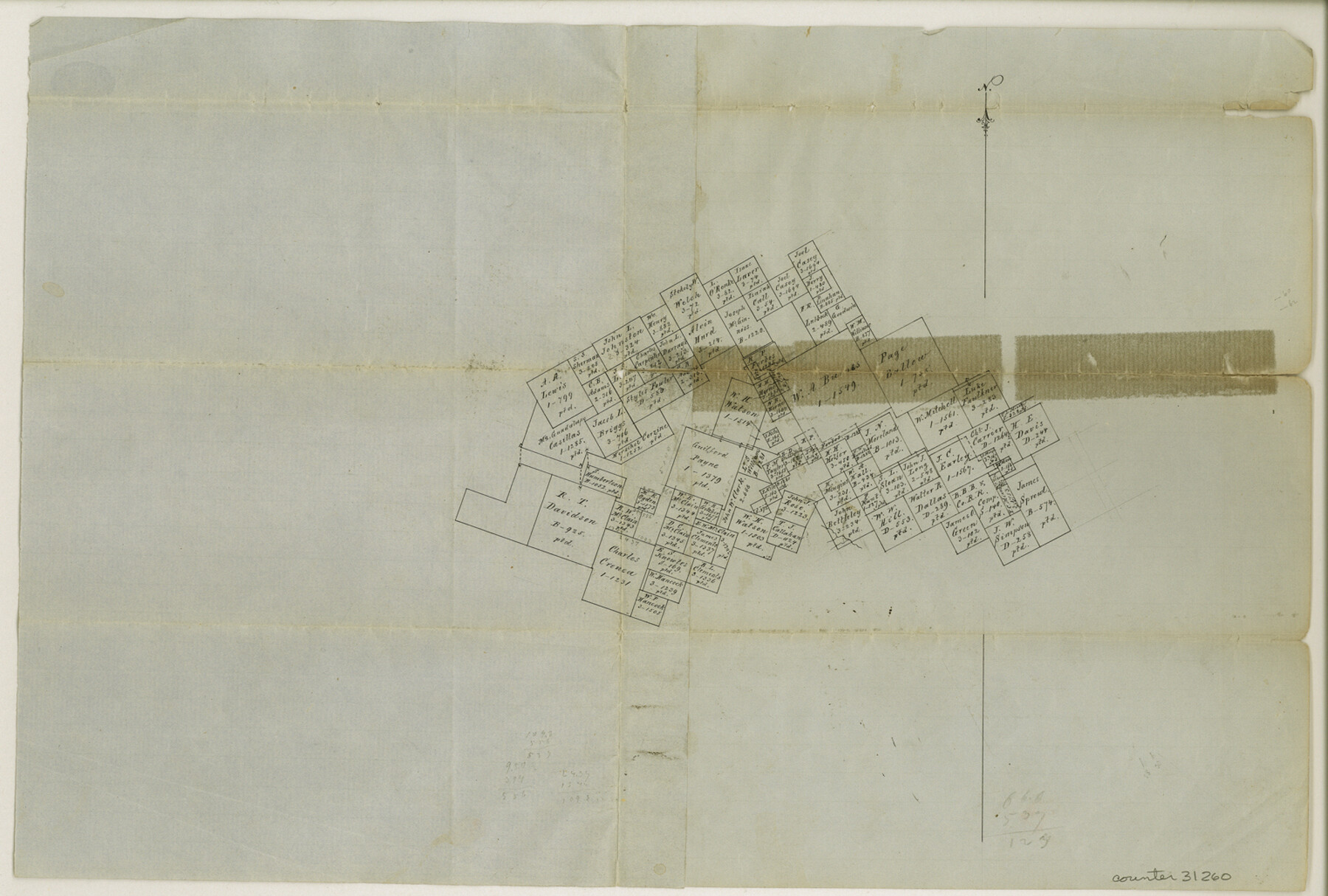
McLennan County Sketch File 10
[Office sketch in southwest part of the county on the waters of Cow Bayou]
-
Map/Doc
31260
-
Collection
General Map Collection
-
Object Dates
9/20/1861 (Creation Date)
-
Counties
McLennan
-
Subjects
Surveying Sketch File
-
Height x Width
10.3 x 15.2 inches
26.2 x 38.6 cm
-
Medium
paper, manuscript
-
Features
Cow Bayou
Part of: General Map Collection
[Sketch for Mineral Application 21493 - Clay County]
![65625, [Sketch for Mineral Application 21493 - Clay County], General Map Collection](https://historictexasmaps.com/wmedia_w700/maps/65625-1.tif.jpg)
Print $40.00
- Digital $50.00
[Sketch for Mineral Application 21493 - Clay County]
Size 62.4 x 34.8 inches
Map/Doc 65625
Smith County Sketch File 5

Print $6.00
- Digital $50.00
Smith County Sketch File 5
1857
Size 8.4 x 7.8 inches
Map/Doc 36754
Hudspeth County Rolled Sketch 76

Print $40.00
- Digital $50.00
Hudspeth County Rolled Sketch 76
1992
Size 49.5 x 37.7 inches
Map/Doc 9239

[San Antonio & Aransas Pass Through Gonzales County]
![64288, [San Antonio & Aransas Pass Through Gonzales County], General Map Collection](https://historictexasmaps.com/wmedia_w700/maps/64288.tif.jpg)
Print $20.00
- Digital $50.00
[San Antonio & Aransas Pass Through Gonzales County]
1880
Size 11.4 x 30.7 inches
Map/Doc 64288
Reeves County Rolled Sketch 35

Print $20.00
- Digital $50.00
Reeves County Rolled Sketch 35
2013
Size 25.3 x 36.8 inches
Map/Doc 93706
Brazos River, Brazos River Sheet 5

Print $20.00
- Digital $50.00
Brazos River, Brazos River Sheet 5
1926
Size 27.4 x 21.7 inches
Map/Doc 69669
Duval County Working Sketch 33

Print $20.00
- Digital $50.00
Duval County Working Sketch 33
1951
Size 21.9 x 23.3 inches
Map/Doc 68757
Cherokee County Working Sketch 6

Print $20.00
- Digital $50.00
Cherokee County Working Sketch 6
1953
Size 40.9 x 35.1 inches
Map/Doc 67961

San Saba County Sketch File 17

Print $8.00
- Digital $50.00
San Saba County Sketch File 17
1918
Size 11.4 x 8.8 inches
Map/Doc 36456
Nueces County Rolled Sketch 82

Print $43.00
Nueces County Rolled Sketch 82
1982
Size 18.6 x 25.0 inches
Map/Doc 6961
You may also like
Fayette County Working Sketch 1

Print $20.00
- Digital $50.00
Fayette County Working Sketch 1
1949
Size 25.4 x 18.0 inches
Map/Doc 69165
Walker County Working Sketch 15

Print $20.00
- Digital $50.00
Walker County Working Sketch 15
1967
Size 26.9 x 24.8 inches
Map/Doc 72295
Lake Corpus Christi and a city map of Mathis, Texas [Recto]
![94170, Lake Corpus Christi and a city map of Mathis, Texas [Recto], General Map Collection](https://historictexasmaps.com/wmedia_w700/maps/94170.tif.jpg)
Lake Corpus Christi and a city map of Mathis, Texas [Recto]
1984
Size 29.2 x 22.8 inches
Map/Doc 94170
Runnels County Working Sketch 34

Print $20.00
- Digital $50.00
Runnels County Working Sketch 34
1974
Size 14.0 x 14.9 inches
Map/Doc 63632
Brazoria County Sketch File 18

Print $18.00
- Digital $50.00
Brazoria County Sketch File 18
Size 14.5 x 8.9 inches
Map/Doc 14989
[Sketch for Mineral Application 14125 - Neches River, R. B. Moore]
![65667, [Sketch for Mineral Application 14125 - Neches River, R. B. Moore], General Map Collection](https://historictexasmaps.com/wmedia_w700/maps/65667.tif.jpg)
Print $40.00
- Digital $50.00
[Sketch for Mineral Application 14125 - Neches River, R. B. Moore]
1928
Size 26.1 x 50.0 inches
Map/Doc 65667
Lynn County Sketch File 19

Print $36.00
- Digital $50.00
Lynn County Sketch File 19
Size 11.2 x 8.7 inches
Map/Doc 30519
Kinney County Rolled Sketch 2

Print $20.00
- Digital $50.00
Kinney County Rolled Sketch 2
Size 24.5 x 36.2 inches
Map/Doc 6534
Flight Mission No. DCL-7C, Frame 73, Kenedy County

Print $20.00
- Digital $50.00
Flight Mission No. DCL-7C, Frame 73, Kenedy County
1943
Size 15.6 x 15.3 inches
Map/Doc 86059
France Baker Farm

Print $3.00
- Digital $50.00
France Baker Farm
Size 9.5 x 12.0 inches
Map/Doc 92332
Stephens County Working Sketch 17

Print $20.00
- Digital $50.00
Stephens County Working Sketch 17
1968
Size 22.7 x 29.1 inches
Map/Doc 63960
Jack County Sketch File 11

Print $4.00
- Digital $50.00
Jack County Sketch File 11
1858
Size 10.2 x 8.1 inches
Map/Doc 27531