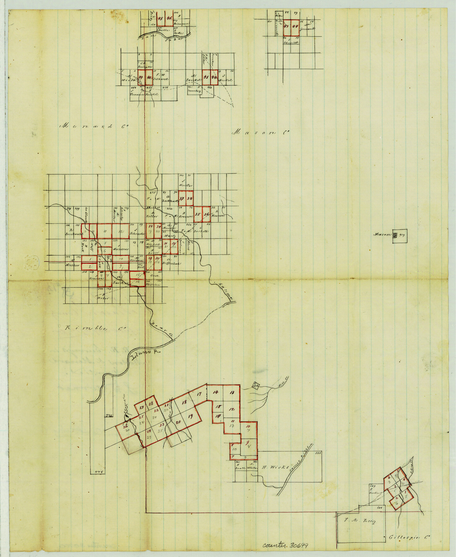
Mason County Sketch File 12
[I. R.R. surveys in Mason, Menard, and Kimble Counties]
-
Map/Doc
30699
-
Collection
General Map Collection
-
Object Dates
5/30/1872 (File Date)
-
Counties
Mason Menard Kimble Gillespie
-
Subjects
Surveying Sketch File
-
Height x Width
15.8 x 12.9 inches
40.1 x 32.8 cm
-
Medium
paper, manuscript
-
Features
San Saba River
Bear Creek
Salina Creek
Mason
Llano River
James River
Schot Creek
Cow Creek
Edmond Creek
Part of: General Map Collection
El Paso County Sketch File 7a

Print $4.00
- Digital $50.00
El Paso County Sketch File 7a
Size 8.5 x 4.1 inches
Map/Doc 22002
Armstrong County Boundary File 3

Print $14.00
- Digital $50.00
Armstrong County Boundary File 3
Size 11.3 x 8.8 inches
Map/Doc 50141
Official Map of the Highway System of Texas

Digital $50.00
Official Map of the Highway System of Texas
1935
Size 25.1 x 25.9 inches
Map/Doc 93721
Dawson County Sketch File 18

Print $10.00
- Digital $50.00
Dawson County Sketch File 18
1940
Size 14.2 x 9.0 inches
Map/Doc 20567
Flight Mission No. DAG-24K, Frame 126, Matagorda County

Print $20.00
- Digital $50.00
Flight Mission No. DAG-24K, Frame 126, Matagorda County
1953
Size 17.0 x 19.1 inches
Map/Doc 86544
United States Base Map

Print $20.00
- Digital $50.00
United States Base Map
1916
Size 19.2 x 29.5 inches
Map/Doc 69653
Hays County Working Sketch 5

Print $20.00
- Digital $50.00
Hays County Working Sketch 5
1929
Size 28.2 x 29.6 inches
Map/Doc 66079
Culberson County Working Sketch 80

Print $40.00
- Digital $50.00
Culberson County Working Sketch 80
1978
Size 56.4 x 43.4 inches
Map/Doc 68534
[Bastrop County line]
![65, [Bastrop County line], General Map Collection](https://historictexasmaps.com/wmedia_w700/maps/65.tif.jpg)
Print $2.00
- Digital $50.00
[Bastrop County line]
1841
Size 7.8 x 6.3 inches
Map/Doc 65
Galveston County Working Sketch 14

Print $20.00
- Digital $50.00
Galveston County Working Sketch 14
1978
Size 33.6 x 40.4 inches
Map/Doc 69351
Crockett County Rolled Sketch 27

Print $20.00
- Digital $50.00
Crockett County Rolled Sketch 27
1925
Size 20.8 x 38.0 inches
Map/Doc 5586

You may also like
Water Valley Sheet, North Concho River, Tom Green County

Print $20.00
- Digital $50.00
Water Valley Sheet, North Concho River, Tom Green County
1937
Size 23.6 x 19.1 inches
Map/Doc 65305
Atascosa County Rolled Sketch R

Print $20.00
- Digital $50.00
Atascosa County Rolled Sketch R
Size 19.6 x 19.6 inches
Map/Doc 5103
Kimble County Sketch File 26

Print $4.00
- Digital $50.00
Kimble County Sketch File 26
1912
Size 7.8 x 13.0 inches
Map/Doc 28969
Bell County Working Sketch 10

Print $20.00
- Digital $50.00
Bell County Working Sketch 10
1954
Size 38.2 x 41.4 inches
Map/Doc 67350
Goliad County Sketch File X

Print $10.00
- Digital $50.00
Goliad County Sketch File X
1893
Size 8.3 x 12.8 inches
Map/Doc 24332
Travis County Appraisal District Plat Map 1_1808

Print $20.00
- Digital $50.00
Travis County Appraisal District Plat Map 1_1808
Size 21.5 x 26.5 inches
Map/Doc 94214
Jeff Davis County Rolled Sketch 37

Print $20.00
- Digital $50.00
Jeff Davis County Rolled Sketch 37
1992
Size 29.3 x 35.5 inches
Map/Doc 6380
Refugio County Sketch File 23

Print $6.00
- Digital $50.00
Refugio County Sketch File 23
1948
Size 11.2 x 8.7 inches
Map/Doc 35280
Flight Mission No. DAG-23K, Frame 152, Matagorda County

Print $20.00
- Digital $50.00
Flight Mission No. DAG-23K, Frame 152, Matagorda County
1953
Size 15.9 x 15.9 inches
Map/Doc 86500
[Sections 55-58, Blk. GG and surrounding surveys]
![90319, [Sections 55-58, Blk. GG and surrounding surveys], Twichell Survey Records](https://historictexasmaps.com/wmedia_w700/maps/90319-1.tif.jpg)
Print $20.00
- Digital $50.00
[Sections 55-58, Blk. GG and surrounding surveys]
Size 41.1 x 29.7 inches
Map/Doc 90319
Crockett County

Print $40.00
- Digital $50.00
Crockett County
1882
Size 57.2 x 38.3 inches
Map/Doc 88864
Bandera County Rolled Sketch 4

Print $20.00
- Digital $50.00
Bandera County Rolled Sketch 4
1963
Size 36.0 x 28.5 inches
Map/Doc 5116