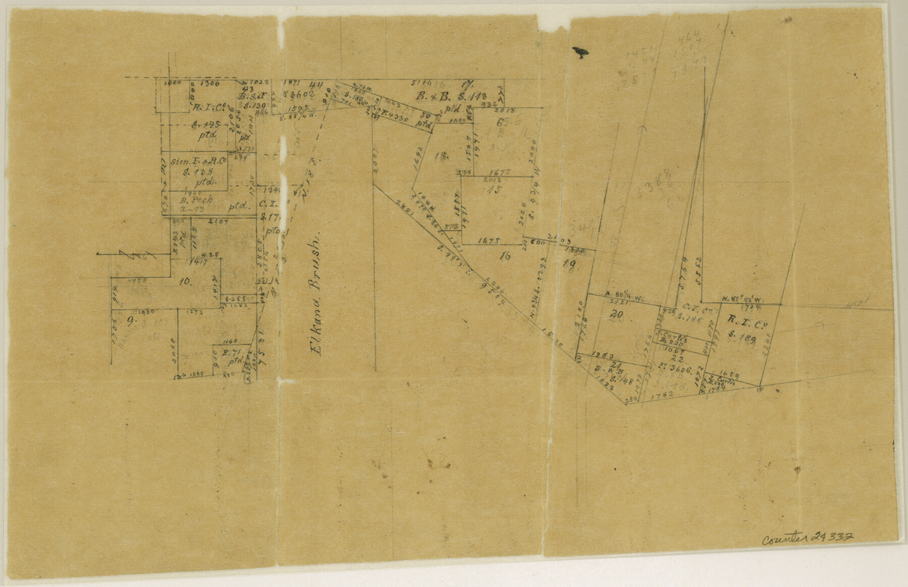
Goliad County Sketch File X
[Sketches of surveys around the E. Brush survey]
-
Map/Doc
24332
-
Collection
General Map Collection
-
Object Dates
3/24/1893 (Creation Date)
-
People and Organizations
Chas. W. Pressler (Draftsman)
-
Counties
Goliad
-
Subjects
Surveying Sketch File
-
Height x Width
8.3 x 12.8 inches
21.1 x 32.5 cm
-
Medium
paper, manuscript
-
Features
Chain Creek
Part of: General Map Collection
[Sketch for Mineral Application 24072, San Jacinto River]
![65587, [Sketch for Mineral Application 24072, San Jacinto River], General Map Collection](https://historictexasmaps.com/wmedia_w700/maps/65587.tif.jpg)
Print $20.00
- Digital $50.00
[Sketch for Mineral Application 24072, San Jacinto River]
1929
Size 19.3 x 16.4 inches
Map/Doc 65587
Matagorda County NRC Article 33.136 Sketch 16

Digital $50.00
Matagorda County NRC Article 33.136 Sketch 16
2023
Map/Doc 97256
Upshur County Sketch File 2a

Print $4.00
- Digital $50.00
Upshur County Sketch File 2a
Size 12.9 x 8.2 inches
Map/Doc 38734
Grayson County Working Sketch 14

Print $20.00
- Digital $50.00
Grayson County Working Sketch 14
1952
Size 23.9 x 23.3 inches
Map/Doc 63253
Hemphill County Rolled Sketch 8

Print $20.00
- Digital $50.00
Hemphill County Rolled Sketch 8
1903
Size 22.7 x 30.5 inches
Map/Doc 6191
Navarro County Sketch File 12

Print $4.00
- Digital $50.00
Navarro County Sketch File 12
Size 7.0 x 7.0 inches
Map/Doc 32322
Flight Mission No. BQR-9K, Frame 53, Brazoria County

Print $20.00
- Digital $50.00
Flight Mission No. BQR-9K, Frame 53, Brazoria County
1952
Size 18.7 x 22.3 inches
Map/Doc 84057
Presidio County Working Sketch 126

Print $20.00
- Digital $50.00
Presidio County Working Sketch 126
1987
Size 36.9 x 46.5 inches
Map/Doc 71804
Wilbarger County Sketch File 18

Print $12.00
- Digital $50.00
Wilbarger County Sketch File 18
1886
Size 14.3 x 8.8 inches
Map/Doc 40209
Wilbarger Co.

Print $40.00
- Digital $50.00
Wilbarger Co.
1907
Size 49.1 x 40.3 inches
Map/Doc 63126
Van Zandt County Sketch File 28

Print $4.00
- Digital $50.00
Van Zandt County Sketch File 28
1859
Size 12.5 x 8.2 inches
Map/Doc 39451
Jeff Davis County Sketch File 22

Print $20.00
- Digital $50.00
Jeff Davis County Sketch File 22
1923
Size 19.4 x 25.0 inches
Map/Doc 11860
You may also like
Brazos River, Brazos River Sheet 1

Print $20.00
- Digital $50.00
Brazos River, Brazos River Sheet 1
1926
Size 20.7 x 25.3 inches
Map/Doc 69665
[Texas & Pacific Railway through Callahan County]
![64237, [Texas & Pacific Railway through Callahan County], General Map Collection](https://historictexasmaps.com/wmedia_w700/maps/64237.tif.jpg)
Print $20.00
- Digital $50.00
[Texas & Pacific Railway through Callahan County]
1918
Size 21.8 x 9.2 inches
Map/Doc 64237
[Galveston, Harrisburg & San Antonio through El Paso County]
![64015, [Galveston, Harrisburg & San Antonio through El Paso County], General Map Collection](https://historictexasmaps.com/wmedia_w700/maps/64015.tif.jpg)
Print $20.00
- Digital $50.00
[Galveston, Harrisburg & San Antonio through El Paso County]
1907
Size 13.5 x 33.7 inches
Map/Doc 64015
Gonzales County Working Sketch 3

Print $20.00
- Digital $50.00
Gonzales County Working Sketch 3
1943
Size 37.8 x 41.5 inches
Map/Doc 63218
Trinity River, Ferris Sheet/Ten Mile Creek

Print $4.00
- Digital $50.00
Trinity River, Ferris Sheet/Ten Mile Creek
1935
Size 20.1 x 25.1 inches
Map/Doc 65242
Bandera County Sketch File 28

Print $40.00
- Digital $50.00
Bandera County Sketch File 28
Size 23.5 x 20.0 inches
Map/Doc 10897
Stonewall County Boundary File 1

Print $34.00
- Digital $50.00
Stonewall County Boundary File 1
Size 9.0 x 8.4 inches
Map/Doc 58938
Kendall County

Print $20.00
- Digital $50.00
Kendall County
1946
Size 42.5 x 36.8 inches
Map/Doc 95553
Amistad International Reservoir on Rio Grande 101

Print $20.00
- Digital $50.00
Amistad International Reservoir on Rio Grande 101
1950
Size 28.5 x 40.9 inches
Map/Doc 75532
Hardin County Sketch File AB

Print $4.00
- Digital $50.00
Hardin County Sketch File AB
Size 13.5 x 7.3 inches
Map/Doc 25071
Newton County Sketch File 12

Print $8.00
- Digital $50.00
Newton County Sketch File 12
Size 8.8 x 7.4 inches
Map/Doc 32382
Flight Mission No. BRE-2P, Frame 7, Nueces County

Print $20.00
- Digital $50.00
Flight Mission No. BRE-2P, Frame 7, Nueces County
1956
Size 18.5 x 22.4 inches
Map/Doc 86716