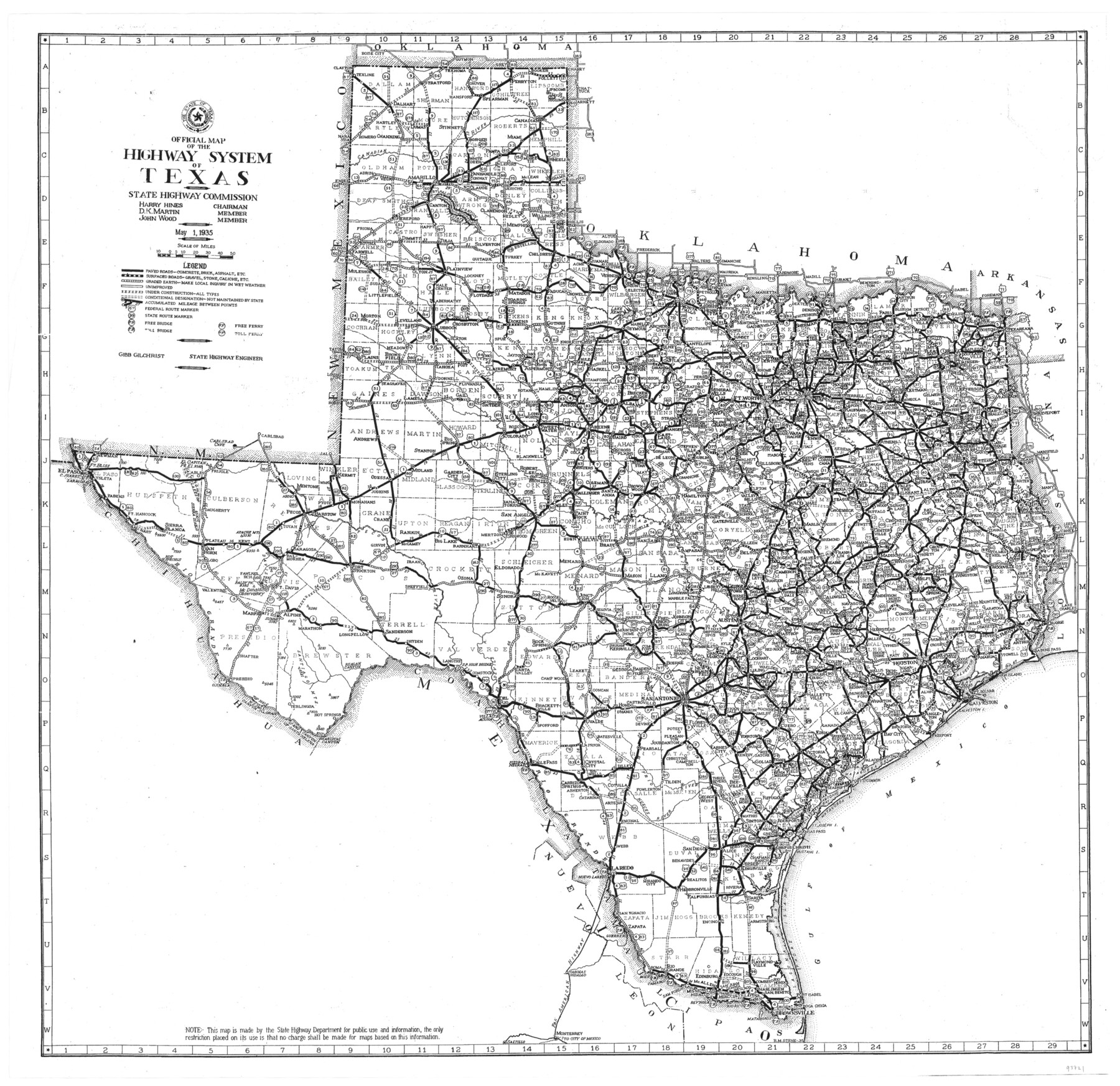
Official Map of the Highway System of Texas
-
Map/Doc
93721
-
Collection
General Map Collection
-
Object Dates
1935/5/1 (Creation Date)
2015/1/7 (File Date)
-
People and Organizations
State Highway Commission (Publisher)
Kenneth Morris of Georgetown, TX (Donor)
-
Subjects
State of Texas
-
Height x Width
25.1 x 25.9 inches
63.8 x 65.8 cm
-
Comments
Map donated by Kenneth Morris of Georgetown, TX.
Part of: General Map Collection
Sutton County Working Sketch 18

Print $20.00
- Digital $50.00
Sutton County Working Sketch 18
1978
Size 39.9 x 31.5 inches
Map/Doc 62361
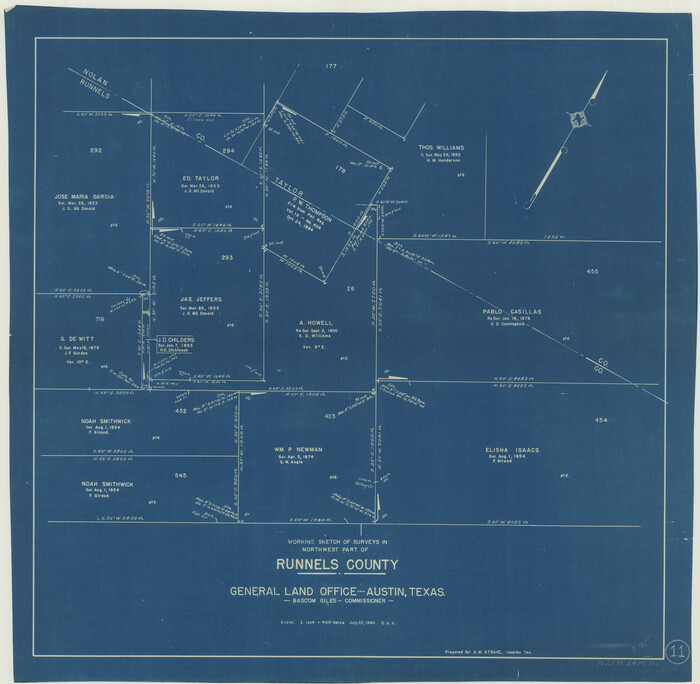
Runnels County Working Sketch 11
Print $20.00
- Digital $50.00
Runnels County Working Sketch 11
1949
Size 24.6 x 25.2 inches
Map/Doc 63607
Archer County Sketch File 24

Print $40.00
- Digital $50.00
Archer County Sketch File 24
1924
Size 31.7 x 25.0 inches
Map/Doc 10832
Map of Harris County

Print $20.00
- Digital $50.00
Map of Harris County
1893
Size 26.9 x 36.5 inches
Map/Doc 66855
Milam County Sketch File 6

Print $4.00
- Digital $50.00
Milam County Sketch File 6
1902
Size 14.2 x 8.6 inches
Map/Doc 31634
King County Working Sketch Graphic Index

Print $20.00
- Digital $50.00
King County Working Sketch Graphic Index
1947
Size 44.2 x 39.5 inches
Map/Doc 76608
Presidio County Rolled Sketch 87

Print $20.00
- Digital $50.00
Presidio County Rolled Sketch 87
Size 26.4 x 38.2 inches
Map/Doc 7373

Webb County Sketch File 12a

Print $20.00
- Digital $50.00
Webb County Sketch File 12a
1886
Size 20.7 x 31.4 inches
Map/Doc 12628
Houston County Working Sketch 29

Print $20.00
- Digital $50.00
Houston County Working Sketch 29
1990
Size 23.4 x 23.1 inches
Map/Doc 66259
El Paso County Rolled Sketch 52

Print $20.00
- Digital $50.00
El Paso County Rolled Sketch 52
1929
Size 18.4 x 24.4 inches
Map/Doc 5842
Haskell County Sketch File 3

Print $8.00
- Digital $50.00
Haskell County Sketch File 3
Size 9.8 x 8.8 inches
Map/Doc 26121
You may also like
Dickens County Rolled Sketch N

Print $20.00
- Digital $50.00
Dickens County Rolled Sketch N
1909
Size 21.2 x 30.6 inches
Map/Doc 5714
Map of Public Roads in Terry County, Texas

Print $20.00
- Digital $50.00
Map of Public Roads in Terry County, Texas
Size 34.0 x 37.4 inches
Map/Doc 91936
Rand, McNally & Co.'s Texas

Print $20.00
- Digital $50.00
Rand, McNally & Co.'s Texas
1902
Size 21.3 x 28.4 inches
Map/Doc 95886

Schleicher County Working Sketch 5

Print $20.00
- Digital $50.00
Schleicher County Working Sketch 5
1917
Size 23.0 x 17.6 inches
Map/Doc 63807
[Strickland Survey Sketch Showing Abercrombie Corner, Exhibit C]
![91370, [Strickland Survey Sketch Showing Abercrombie Corner, Exhibit C], Twichell Survey Records](https://historictexasmaps.com/wmedia_w700/maps/91370-1.tif.jpg)
Print $20.00
- Digital $50.00
[Strickland Survey Sketch Showing Abercrombie Corner, Exhibit C]
Size 25.3 x 19.1 inches
Map/Doc 91370
Correct Map of Lamb County, Texas

Print $40.00
- Digital $50.00
Correct Map of Lamb County, Texas
1914
Size 47.1 x 57.1 inches
Map/Doc 89954
Blanco County Sketch File 52

Print $4.00
- Digital $50.00
Blanco County Sketch File 52
Size 11.3 x 8.9 inches
Map/Doc 76332
Nueces County Rolled Sketch 62

Print $20.00
- Digital $50.00
Nueces County Rolled Sketch 62
1977
Size 25.0 x 33.3 inches
Map/Doc 6908
[Map showing Jno. H. Gibson Block D]
![92005, [Map showing Jno. H. Gibson Block D], Twichell Survey Records](https://historictexasmaps.com/wmedia_w700/maps/92005-1.tif.jpg)
Print $20.00
- Digital $50.00
[Map showing Jno. H. Gibson Block D]
Size 18.3 x 15.9 inches
Map/Doc 92005
Anderson County Sketch File 25

Print $40.00
- Digital $50.00
Anderson County Sketch File 25
1969
Size 40.9 x 21.9 inches
Map/Doc 10316
Map of the Navosoto [sp.] River, Washington County
![64, Map of the Navosoto [sp.] River, Washington County, General Map Collection](https://historictexasmaps.com/wmedia_w700/maps/64.tif.jpg)
Print $20.00
- Digital $50.00
Map of the Navosoto [sp.] River, Washington County
1842
Size 15.7 x 14.2 inches
Map/Doc 64