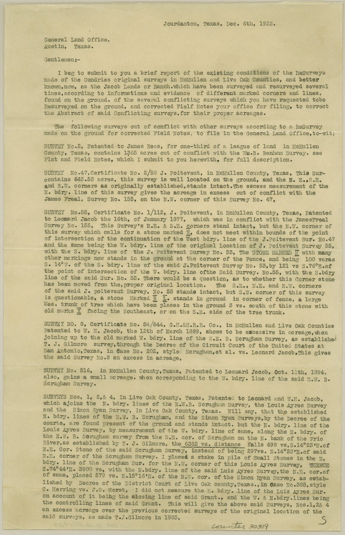
Live Oak County Sketch File 29
[Surveyor's statement regarding Jacob Ranch]
-
Map/Doc
30319
-
Collection
General Map Collection
-
Object Dates
12/6/1922 (Creation Date)
2/10/1923 (File Date)
12/6/1922 (Correspondence Date)
-
People and Organizations
Delany W. Cobb (Surveyor/Engineer)
J.T. Gilmore (Surveyor/Engineer)
-
Counties
Live Oak McMullen
-
Subjects
Surveying Sketch File
-
Height x Width
13.5 x 8.7 inches
34.3 x 22.1 cm
-
Medium
paper, print
-
Features
Jacob Ranch
Part of: General Map Collection
Starr County Sketch File 46 1/2

Print $20.00
- Digital $50.00
Starr County Sketch File 46 1/2
1978
Size 17.9 x 17.2 inches
Map/Doc 12344
DeWitt County Working Sketch 13

Print $20.00
- Digital $50.00
DeWitt County Working Sketch 13
1986
Size 37.6 x 40.9 inches
Map/Doc 68603
Duval County Working Sketch 58

Print $20.00
- Digital $50.00
Duval County Working Sketch 58
Size 21.0 x 33.0 inches
Map/Doc 67498
Atascosa County Working Sketch 8

Print $20.00
- Digital $50.00
Atascosa County Working Sketch 8
1913
Size 15.5 x 19.8 inches
Map/Doc 67204
Leon County Rolled Sketch 35

Print $20.00
- Digital $50.00
Leon County Rolled Sketch 35
2018
Size 30.7 x 21.3 inches
Map/Doc 95288
Flight Mission No. DQN-7K, Frame 13, Calhoun County

Print $20.00
- Digital $50.00
Flight Mission No. DQN-7K, Frame 13, Calhoun County
1953
Size 18.4 x 22.1 inches
Map/Doc 84464
Railroad Track Map, H&TCRRCo., Falls County, Texas

Print $4.00
- Digital $50.00
Railroad Track Map, H&TCRRCo., Falls County, Texas
1918
Size 11.4 x 18.7 inches
Map/Doc 62849
Borden County Sketch File 6

Print $8.00
- Digital $50.00
Borden County Sketch File 6
1900
Size 11.2 x 8.7 inches
Map/Doc 14719
Flight Mission No. DIX-6P, Frame 202, Aransas County

Print $20.00
- Digital $50.00
Flight Mission No. DIX-6P, Frame 202, Aransas County
1956
Size 19.2 x 22.7 inches
Map/Doc 83864
Runnels County Rolled Sketch 51

Print $20.00
- Digital $50.00
Runnels County Rolled Sketch 51
Size 26.1 x 34.3 inches
Map/Doc 7536
Nueces County Rolled Sketch 94

Print $108.00
Nueces County Rolled Sketch 94
1983
Size 24.2 x 36.6 inches
Map/Doc 7044
Map of Archer County

Print $20.00
- Digital $50.00
Map of Archer County
1886
Size 24.4 x 20.5 inches
Map/Doc 3240
You may also like
Calhoun County Rolled Sketch 10

Print $20.00
- Digital $50.00
Calhoun County Rolled Sketch 10
Size 32.9 x 29.2 inches
Map/Doc 5366
Hardin County Sketch File 12

Print $4.00
- Digital $50.00
Hardin County Sketch File 12
Size 5.4 x 8.2 inches
Map/Doc 25116
Pecos County Working Sketch 41

Print $20.00
- Digital $50.00
Pecos County Working Sketch 41
1942
Size 19.0 x 31.7 inches
Map/Doc 71513
Howard County Working Sketch 4

Print $20.00
- Digital $50.00
Howard County Working Sketch 4
1940
Size 21.5 x 18.3 inches
Map/Doc 66270
Grayson County Rolled Sketch 2

Print $20.00
- Digital $50.00
Grayson County Rolled Sketch 2
1951
Size 25.5 x 42.5 inches
Map/Doc 6030
Calhoun County Rolled Sketch 30

Print $20.00
- Digital $50.00
Calhoun County Rolled Sketch 30
1974
Size 18.5 x 27.6 inches
Map/Doc 5492

Edwards County Working Sketch 29

Print $40.00
- Digital $50.00
Edwards County Working Sketch 29
1946
Size 44.9 x 53.9 inches
Map/Doc 68905
Nolan County Sketch File 4

Print $20.00
- Digital $50.00
Nolan County Sketch File 4
Size 38.8 x 33.0 inches
Map/Doc 10557
Runnels County Sketch File 28

Print $6.00
Runnels County Sketch File 28
1949
Size 11.3 x 8.8 inches
Map/Doc 35493
Geodetic positions of authentic boundary mounds, established by Louisiana Geodetic Survey traverse

Print $4.00
- Digital $50.00
Geodetic positions of authentic boundary mounds, established by Louisiana Geodetic Survey traverse
Size 28.8 x 28.7 inches
Map/Doc 1734
Overlay For Flight Mission No. BRE-2P, Frame 110 of H. A. Pierce Corrected Survey, December 21, 1950 of Cyrus Egery Survey of June 15, 1855

Print $20.00
- Digital $50.00
Overlay For Flight Mission No. BRE-2P, Frame 110 of H. A. Pierce Corrected Survey, December 21, 1950 of Cyrus Egery Survey of June 15, 1855
1956
Size 18.3 x 20.4 inches
Map/Doc 86795