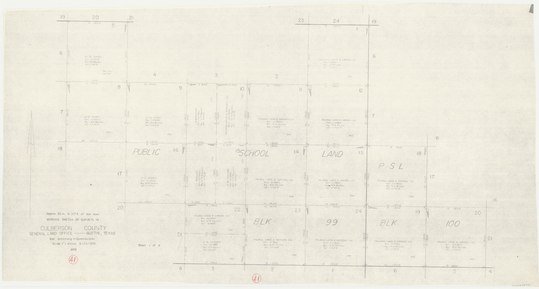
Culberson County Working Sketch 41
- 
                          Map/Doc68495
- 
                            CollectionGeneral Map Collection
- 
                            Object Dates3/23/1970 (Creation Date)
- 
                            CountiesCulberson
- 
                            SubjectsSurveying Working Sketch
- 
                            Height x Width22.9 x 42.6 inches58.2 x 108.2 cm
- 
                            Scale1" = 400 varas
Part of: General Map Collection
            Wise County Working Sketch 25


                                            Print $40.00                    
                                             -                         Digital $50.00                                    
                Wise County Working Sketch 25
1983
Size 37.1 x 53.8 inches
                                Map/Doc 72639
            
            Leon County Sketch File 7


                                            Print $6.00                    
                                             -                         Digital $50.00                                    
                Leon County Sketch File 7
1858
Size 12.4 x 8.2 inches
                                Map/Doc 29721
            
            Stephens County Sketch File 10c


                                            Print $6.00                    
                                             -                         Digital $50.00                                    
                Stephens County Sketch File 10c
Size 7.8 x 11.5 inches
                                Map/Doc 37052
            
            Gaines County Working Sketch 27


                                            Print $20.00                    
                                             -                         Digital $50.00                                    
                Gaines County Working Sketch 27
Size 17.4 x 36.7 inches
                                Map/Doc 69327
            
            St. Louis, Brownsville & Mexico Railway Location Map from Mile 20 to Mile 40


                                            Print $40.00                    
                                             -                         Digital $50.00                                    
                St. Louis, Brownsville & Mexico Railway Location Map from Mile 20 to Mile 40
1905
Size 19.2 x 61.4 inches
                                Map/Doc 64078
            
            Flight Mission No. CRC-3R, Frame 206, Chambers County


                                            Print $20.00                    
                                             -                         Digital $50.00                                    
                Flight Mission No. CRC-3R, Frame 206, Chambers County
1956
Size 18.5 x 22.2 inches
                                Map/Doc 84861
            
            Old Miscellaneous File 5


                                            Print $4.00                    
                                             -                         Digital $50.00                                    
                Old Miscellaneous File 5
1846
Size 4.8 x 7.6 inches
                                Map/Doc 75418
            
            Map of Texas in 1830 Showing Spanish Colonies


                                            Print $20.00                    
                                             -                         Digital $50.00                                    
                Map of Texas in 1830 Showing Spanish Colonies
Size 41.1 x 42.0 inches
                                Map/Doc 73588
            
            Kendall County Rolled Sketch 8


                                            Print $20.00                    
                                             -                         Digital $50.00                                    
                Kendall County Rolled Sketch 8
1994
Size 17.0 x 18.3 inches
                                Map/Doc 6461
            
            Taylor County Sketch File 2


                                            Print $20.00                    
                                             -                         Digital $50.00                                    
                Taylor County Sketch File 2
Size 13.8 x 18.4 inches
                                Map/Doc 12408
            
            Gulf Coast of the United States, Key West to Rio Grande


                                            Print $20.00                    
                                             -                         Digital $50.00                                    
                Gulf Coast of the United States, Key West to Rio Grande
1892
Size 27.3 x 18.3 inches
                                Map/Doc 72671
            You may also like
            Map Showing Corrections of Capitol Leagues in Conflict in Oldham Co.


                                            Print $40.00                    
                                             -                         Digital $50.00                                    
                Map Showing Corrections of Capitol Leagues in Conflict in Oldham Co.
1886
Size 52.5 x 31.3 inches
                                Map/Doc 89800
            
            Bailey County


                                            Print $20.00                    
                                             -                         Digital $50.00                                    
                Bailey County
1913
Size 28.8 x 22.3 inches
                                Map/Doc 66707
            
            The Chief Justice County of Jasper. Lands in Conflict with Sabine County


                                            Print $20.00                    
                                    
                The Chief Justice County of Jasper. Lands in Conflict with Sabine County
2020
Size 18.3 x 21.7 inches
                                Map/Doc 96053
            
            Calhoun County Rolled Sketch 6


                                            Print $20.00                    
                                             -                         Digital $50.00                                    
                Calhoun County Rolled Sketch 6
Size 24.0 x 22.5 inches
                                Map/Doc 5362
            
            Clay County Boundary File 9


                                            Print $8.00                    
                                             -                         Digital $50.00                                    
                Clay County Boundary File 9
Size 7.7 x 8.2 inches
                                Map/Doc 51393
            
            Flight Mission No. CRC-2R, Frame 180, Chambers County


                                            Print $20.00                    
                                             -                         Digital $50.00                                    
                Flight Mission No. CRC-2R, Frame 180, Chambers County
1956
Size 18.7 x 22.4 inches
                                Map/Doc 84758
            
            Hutchinson County Working Sketch 39


                                            Print $20.00                    
                                             -                         Digital $50.00                                    
                Hutchinson County Working Sketch 39
1978
Size 27.4 x 23.2 inches
                                Map/Doc 66399
            
            Flight Mission No. BRA-8M, Frame 123, Jefferson County


                                            Print $20.00                    
                                             -                         Digital $50.00                                    
                Flight Mission No. BRA-8M, Frame 123, Jefferson County
1953
Size 18.7 x 22.3 inches
                                Map/Doc 85619
            
            Right of Way and Track Map, International & Gt. Northern Ry. Operated by the International & Gt. Northern Ry. Co. Gulf Division, Mineola Branch


                                            Print $40.00                    
                                             -                         Digital $50.00                                    
                Right of Way and Track Map, International & Gt. Northern Ry. Operated by the International & Gt. Northern Ry. Co. Gulf Division, Mineola Branch
1917
Size 25.5 x 116.7 inches
                                Map/Doc 64701
            
            United States Gulf Coast - from Galveston to the Rio Grande


                                            Print $20.00                    
                                             -                         Digital $50.00                                    
                United States Gulf Coast - from Galveston to the Rio Grande
1915
Size 26.9 x 18.3 inches
                                Map/Doc 72732
            
            [Sketch for Mineral Application 16700 - Pecos River Bed]
            
                                    ![2811, [Sketch for Mineral Application 16700 - Pecos River Bed], General Map Collection](https://historictexasmaps.com/wmedia_w700/maps/2811.tif.jpg) 


    ![2811, [Sketch for Mineral Application 16700 - Pecos River Bed], General Map Collection](https://historictexasmaps.com/wmedia_w700/maps/2811.tif.jpg) 
                                
            
                                            Print $20.00                    
                                             -                         Digital $50.00                                    
                [Sketch for Mineral Application 16700 - Pecos River Bed]
1927
Size 20.6 x 28.6 inches
                                Map/Doc 2811
            
            Jeff Davis County Rolled Sketch 8


                                            Print $20.00                    
                                             -                         Digital $50.00                                    
                Jeff Davis County Rolled Sketch 8
Size 40.0 x 41.6 inches
                                Map/Doc 9264
             
                        