Brazoria County Sketch File 48
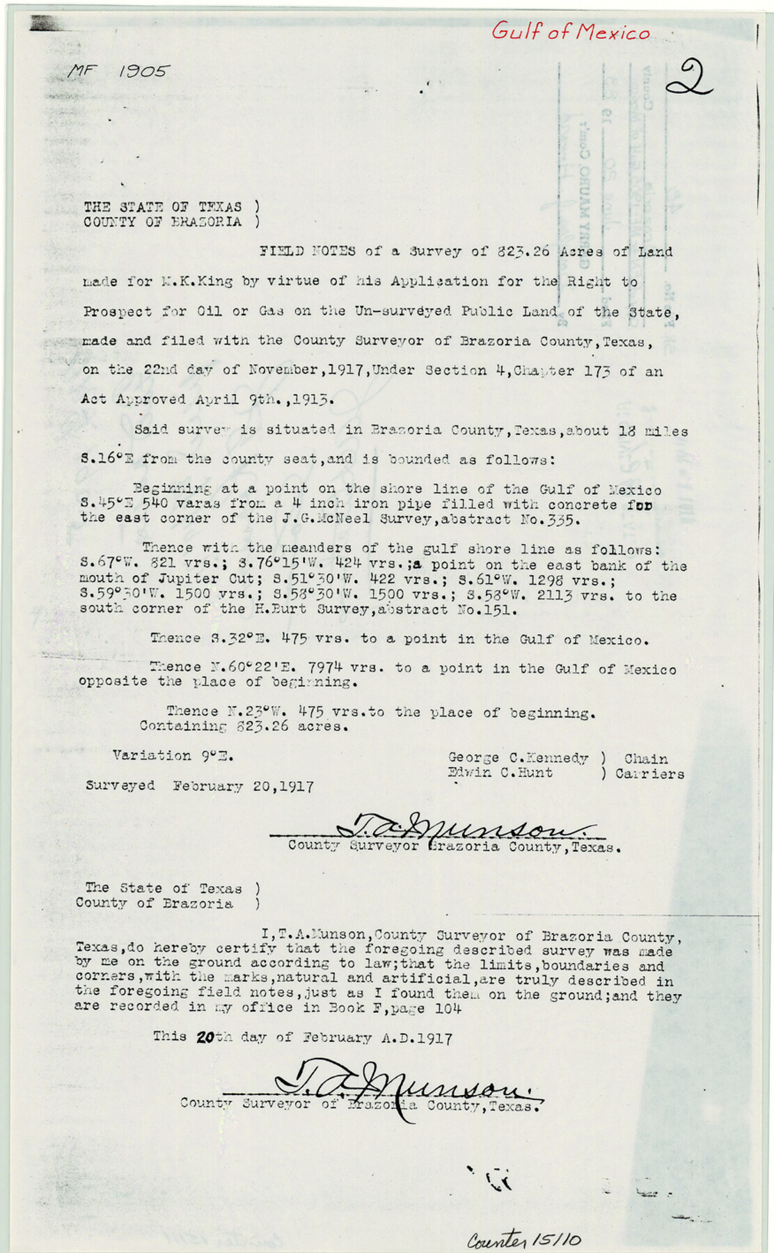
[Copy of field notes from MF-1905, Gulf of Mexico]
-
Map/Doc
15110
-
Collection
General Map Collection
-
Object Dates
1983/6/20 (File Date)
1917/2/20 (Survey Date)
-
People and Organizations
T.A. Munson (Surveyor/Engineer)
George C. Kennedy (Chainman)
Edwin C. Hunt (Chainman)
-
Counties
Brazoria
-
Subjects
Surveying Sketch File
-
Height x Width
14.2 x 8.8 inches
36.1 x 22.4 cm
-
Medium
paper, photocopy
-
Features
Gulf of Mexico
Part of: General Map Collection
Newton County Rolled Sketch 24
Print $20.00
- Digital $50.00
Newton County Rolled Sketch 24
1893
Size 18.8 x 20.8 inches
Map/Doc 6851
Controlled Mosaic by Jack Amman Photogrammetric Engineers, Inc - Sheet 31

Print $20.00
- Digital $50.00
Controlled Mosaic by Jack Amman Photogrammetric Engineers, Inc - Sheet 31
1954
Size 20.0 x 24.0 inches
Map/Doc 83484
Amistad International Reservoir on Rio Grande 70a

Print $20.00
- Digital $50.00
Amistad International Reservoir on Rio Grande 70a
1949
Size 28.5 x 39.5 inches
Map/Doc 73357
Gregg County Rolled Sketch 20

Print $20.00
- Digital $50.00
Gregg County Rolled Sketch 20
1957
Size 34.0 x 44.4 inches
Map/Doc 9070
Map of east part of West Bay & SW part of Galveston Bay, Galveston County showing subdivision for mineral development

Print $40.00
- Digital $50.00
Map of east part of West Bay & SW part of Galveston Bay, Galveston County showing subdivision for mineral development
1963
Size 43.0 x 60.8 inches
Map/Doc 2976
Pecos County Sketch File 102

Print $4.00
- Digital $50.00
Pecos County Sketch File 102
Size 9.9 x 4.4 inches
Map/Doc 34014
Flight Mission No. DCL-6C, Frame 98, Kenedy County

Print $20.00
- Digital $50.00
Flight Mission No. DCL-6C, Frame 98, Kenedy County
1943
Size 18.6 x 22.3 inches
Map/Doc 85928
Milam County Boundary File 5a

Print $12.00
- Digital $50.00
Milam County Boundary File 5a
Size 14.1 x 8.5 inches
Map/Doc 57233
Pecos County Rolled Sketch 42

Print $20.00
- Digital $50.00
Pecos County Rolled Sketch 42
1909
Size 19.6 x 41.0 inches
Map/Doc 7220
Hemphill County Working Sketch 6

Print $20.00
- Digital $50.00
Hemphill County Working Sketch 6
1950
Size 20.3 x 27.0 inches
Map/Doc 66101

Hudspeth County Sketch File 50

Print $20.00
- Digital $50.00
Hudspeth County Sketch File 50
Size 11.2 x 8.7 inches
Map/Doc 42948
You may also like

Cass County Working Sketch 50

Print $20.00
- Digital $50.00
Cass County Working Sketch 50
Size 42.6 x 37.7 inches
Map/Doc 67953
Gillespie County Sketch File 7a

Print $4.00
- Digital $50.00
Gillespie County Sketch File 7a
Size 3.5 x 8.1 inches
Map/Doc 24143
Stephens County Working Sketch 38

Print $20.00
- Digital $50.00
Stephens County Working Sketch 38
1988
Size 24.3 x 32.7 inches
Map/Doc 63981
Travis County State Real Property Sketch 13

Print $26.00
- Digital $50.00
Travis County State Real Property Sketch 13
2006
Size 35.3 x 24.1 inches
Map/Doc 88620
No. 3 Chart of Channel connecting Corpus Christi Bay with Aransas Bay, Texas

Print $20.00
- Digital $50.00
No. 3 Chart of Channel connecting Corpus Christi Bay with Aransas Bay, Texas
1878
Size 18.1 x 27.8 inches
Map/Doc 72780
Calhoun County Sketch File 12

Print $120.00
- Digital $50.00
Calhoun County Sketch File 12
Size 23.0 x 36.9 inches
Map/Doc 11033
Nacogdoches County Sketch File 20

Print $26.00
- Digital $50.00
Nacogdoches County Sketch File 20
Size 12.6 x 7.9 inches
Map/Doc 32275
Coast of Texas from head of East Bay Galveston Harbor to Sabine Pass

Print $40.00
- Digital $50.00
Coast of Texas from head of East Bay Galveston Harbor to Sabine Pass
1882
Size 32.3 x 53.9 inches
Map/Doc 69840
Schleicher County Working Sketch 8

Print $20.00
- Digital $50.00
Schleicher County Working Sketch 8
1923
Size 21.6 x 18.6 inches
Map/Doc 63810
Flight Mission No. DIX-8P, Frame 72, Aransas County

Print $20.00
- Digital $50.00
Flight Mission No. DIX-8P, Frame 72, Aransas County
1956
Size 18.7 x 22.4 inches
Map/Doc 83903
Pecos County Working Sketch 112

Print $40.00
- Digital $50.00
Pecos County Working Sketch 112
Size 48.1 x 37.0 inches
Map/Doc 71585