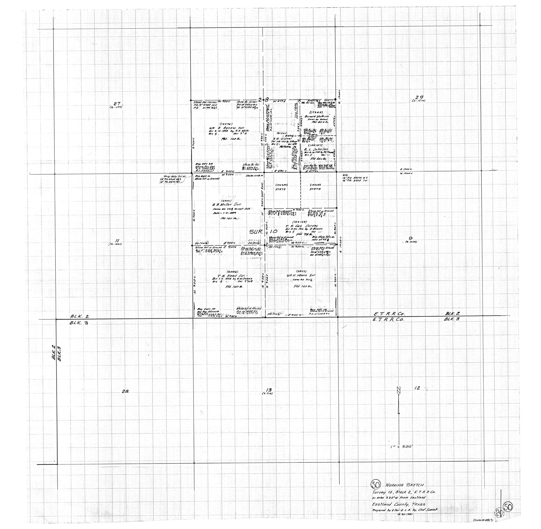
Eastland County Working Sketch 50
-
Map/Doc
68831
-
Collection
General Map Collection
-
Object Dates
12/30/1981 (Creation Date)
-
People and Organizations
Clinton H. Sumrall (Draftsman)
-
Counties
Eastland
-
Subjects
Surveying Working Sketch
-
Height x Width
38.7 x 39.6 inches
98.3 x 100.6 cm
-
Scale
1" = 500 feet
Part of: General Map Collection
Crockett County Sketch File 95

Print $24.00
- Digital $50.00
Crockett County Sketch File 95
Size 11.2 x 8.9 inches
Map/Doc 19952
Flight Mission No. DIX-8P, Frame 62, Aransas County

Print $20.00
- Digital $50.00
Flight Mission No. DIX-8P, Frame 62, Aransas County
1956
Size 18.5 x 22.2 inches
Map/Doc 83893
Hardin County Sketch File 69

Print $20.00
- Digital $50.00
Hardin County Sketch File 69
1944
Size 25.1 x 22.0 inches
Map/Doc 11641
Haskell County

Print $20.00
- Digital $50.00
Haskell County
1888
Size 38.5 x 37.1 inches
Map/Doc 4700
Edwards County Boundary File 28

Print $50.00
- Digital $50.00
Edwards County Boundary File 28
Size 12.9 x 5.2 inches
Map/Doc 52932
Maps & Lists Showing Prison Lands (Oil & Gas) Leased as of June 1955

Digital $50.00
Maps & Lists Showing Prison Lands (Oil & Gas) Leased as of June 1955
Size 8.7 x 11.2 inches
Map/Doc 62869
Comanche County Sketch File 22

Print $4.00
- Digital $50.00
Comanche County Sketch File 22
1873
Size 15.2 x 9.2 inches
Map/Doc 19106
Flight Mission No. DQN-2K, Frame 85, Calhoun County

Print $20.00
- Digital $50.00
Flight Mission No. DQN-2K, Frame 85, Calhoun County
1953
Size 18.8 x 22.4 inches
Map/Doc 84275
Flight Mission No. DQO-12K, Frame 35, Galveston County

Print $20.00
- Digital $50.00
Flight Mission No. DQO-12K, Frame 35, Galveston County
1952
Size 18.7 x 22.4 inches
Map/Doc 85226
Ochiltree County Sketch File 4

Print $10.00
- Digital $50.00
Ochiltree County Sketch File 4
1915
Size 11.3 x 8.7 inches
Map/Doc 33179
Duval County Boundary File 3a

Print $8.00
- Digital $50.00
Duval County Boundary File 3a
Size 12.7 x 8.0 inches
Map/Doc 52726
Blanco County Sketch File 41

Print $6.00
- Digital $50.00
Blanco County Sketch File 41
Size 9.6 x 14.3 inches
Map/Doc 14654
You may also like
Chambers County NRC Article 33.136 Sketch 13

Print $22.00
Chambers County NRC Article 33.136 Sketch 13
Size 35.9 x 23.2 inches
Map/Doc 97014

Runnels County Rolled Sketch C
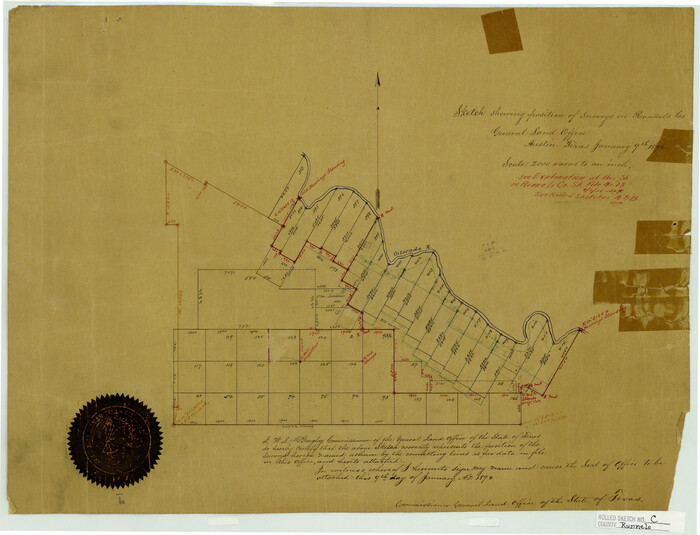
Print $20.00
- Digital $50.00
Runnels County Rolled Sketch C
1892
Size 16.0 x 21.0 inches
Map/Doc 7541
Haskell County Sketch File 26

Print $9.00
- Digital $50.00
Haskell County Sketch File 26
1992
Size 11.3 x 8.8 inches
Map/Doc 26182
Map of Texas coastal area showing submerged area to which counties along the Gulf of Mexico are entitled

Print $20.00
- Digital $50.00
Map of Texas coastal area showing submerged area to which counties along the Gulf of Mexico are entitled
1939
Size 28.3 x 44.2 inches
Map/Doc 3105
Nueces County Rolled Sketch 53

Print $63.00
- Digital $50.00
Nueces County Rolled Sketch 53
1978
Size 10.1 x 15.1 inches
Map/Doc 47862
Reeves County Sketch File 2

Print $26.00
- Digital $50.00
Reeves County Sketch File 2
Size 31.2 x 19.6 inches
Map/Doc 12239
Bexar County Sketch File 36d

Print $40.00
- Digital $50.00
Bexar County Sketch File 36d
1878
Size 21.1 x 26.0 inches
Map/Doc 10923
Pecos County Sketch File 42

Print $30.00
- Digital $50.00
Pecos County Sketch File 42
1919
Size 9.1 x 8.0 inches
Map/Doc 33735
Map of Texas and part of New Mexico compiled in the Bureau of Topographl. Engrs. chiefly for military purposes

Print $20.00
- Digital $50.00
Map of Texas and part of New Mexico compiled in the Bureau of Topographl. Engrs. chiefly for military purposes
1857
Size 18.8 x 24.8 inches
Map/Doc 97116
Leon County Working Sketch 43

Print $40.00
- Digital $50.00
Leon County Working Sketch 43
1980
Size 55.1 x 38.0 inches
Map/Doc 70442
Bird's Eye View of the City of Galveston Texas

Print $20.00
Bird's Eye View of the City of Galveston Texas
1871
Size 20.4 x 30.8 inches
Map/Doc 89086