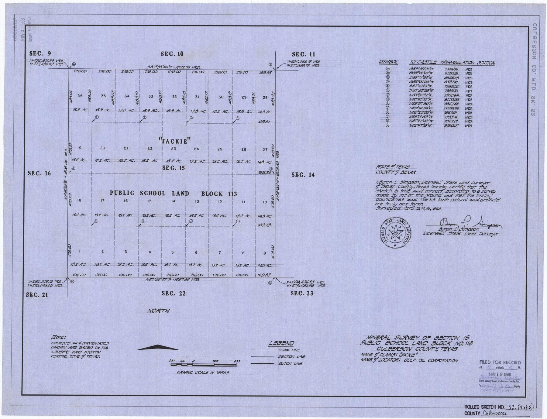
Culberson County Rolled Sketch 52
Mineral survey of section 15, Public School Land Block No. 113, Culberson County, Texas
-
Map/Doc
5674
-
Collection
General Map Collection
-
Object Dates
1966/4/15 (Survey Date)
1966/11/3 (File Date)
-
People and Organizations
Byron L. Simpson (Surveyor/Engineer)
-
Counties
Culberson
-
Subjects
Surveying Rolled Sketch
-
Height x Width
19.2 x 25.1 inches
48.8 x 63.8 cm
-
Medium
linen, manuscript
Part of: General Map Collection
Clay County Boundary File 9

Print $8.00
- Digital $50.00
Clay County Boundary File 9
Size 7.7 x 8.2 inches
Map/Doc 51393
[Right of Way and Track Map, the Missouri, Kansas and Texas Ry. of Texas - Henrietta Division]
![64757, [Right of Way and Track Map, the Missouri, Kansas and Texas Ry. of Texas - Henrietta Division], General Map Collection](https://historictexasmaps.com/wmedia_w700/maps/64757.tif.jpg)
Print $20.00
- Digital $50.00
[Right of Way and Track Map, the Missouri, Kansas and Texas Ry. of Texas - Henrietta Division]
1918
Size 11.8 x 26.9 inches
Map/Doc 64757
Clay County Boundary File 4

Print $14.00
- Digital $50.00
Clay County Boundary File 4
Size 10.1 x 6.7 inches
Map/Doc 51366
Liberty County Working Sketch 29

Print $20.00
- Digital $50.00
Liberty County Working Sketch 29
1943
Size 27.3 x 17.0 inches
Map/Doc 70488
Hidalgo County

Print $20.00
- Digital $50.00
Hidalgo County
1911
Size 42.1 x 29.6 inches
Map/Doc 66863
Baylor County Sketch File 11A

Print $40.00
- Digital $50.00
Baylor County Sketch File 11A
Size 33.9 x 32.0 inches
Map/Doc 10322
Presidio County Rolled Sketch T-3

Print $20.00
- Digital $50.00
Presidio County Rolled Sketch T-3
Size 36.6 x 28.9 inches
Map/Doc 7417
Hudspeth County Working Sketch 16

Print $40.00
- Digital $50.00
Hudspeth County Working Sketch 16
1957
Size 21.1 x 71.2 inches
Map/Doc 66298

Medina County Working Sketch 8

Print $20.00
- Digital $50.00
Medina County Working Sketch 8
1955
Size 23.4 x 18.4 inches
Map/Doc 70923
Maps of Gulf Intracoastal Waterway, Texas - Sabine River to the Rio Grande and connecting waterways including ship channels

Print $20.00
- Digital $50.00
Maps of Gulf Intracoastal Waterway, Texas - Sabine River to the Rio Grande and connecting waterways including ship channels
1966
Size 14.6 x 22.3 inches
Map/Doc 61959
Webb County Rolled Sketch 29

Print $20.00
- Digital $50.00
Webb County Rolled Sketch 29
1932
Size 16.5 x 15.3 inches
Map/Doc 8187
You may also like
Hutchinson County Sketch File 21

Print $22.00
- Digital $50.00
Hutchinson County Sketch File 21
Size 8.8 x 7.9 inches
Map/Doc 27242
[Sections 58-63, I. & G. N. Block 1 and adjacent area to the west]
![91641, [Sections 58-63, I. & G. N. Block 1 and adjacent area to the west], Twichell Survey Records](https://historictexasmaps.com/wmedia_w700/maps/91641-1.tif.jpg)
Print $20.00
- Digital $50.00
[Sections 58-63, I. & G. N. Block 1 and adjacent area to the west]
Size 22.6 x 14.8 inches
Map/Doc 91641
Eastland County Working Sketch 62

Print $20.00
- Digital $50.00
Eastland County Working Sketch 62
1989
Size 20.7 x 28.0 inches
Map/Doc 68843
[Sketch of counties just south of the Panhandle]
![90913, [Sketch of counties just south of the Panhandle], Twichell Survey Records](https://historictexasmaps.com/wmedia_w700/maps/90913-1.tif.jpg)
Print $20.00
- Digital $50.00
[Sketch of counties just south of the Panhandle]
Size 42.7 x 34.8 inches
Map/Doc 90913
Wichita County Sketch File 32

Print $12.00
- Digital $50.00
Wichita County Sketch File 32
1939
Size 14.2 x 8.8 inches
Map/Doc 40146
Jackson County Sketch File 25

Print $20.00
- Digital $50.00
Jackson County Sketch File 25
1942
Size 15.4 x 37.4 inches
Map/Doc 11845
Map of T. C. Ivey's Ranch Block D - John H. Gibson

Print $20.00
- Digital $50.00
Map of T. C. Ivey's Ranch Block D - John H. Gibson
Size 13.9 x 14.0 inches
Map/Doc 92853
Edwards County Working Sketch 128

Print $20.00
- Digital $50.00
Edwards County Working Sketch 128
1981
Size 26.5 x 32.4 inches
Map/Doc 69004

Flight Mission No. BRE-1P, Frame 58, Nueces County

Print $20.00
- Digital $50.00
Flight Mission No. BRE-1P, Frame 58, Nueces County
1956
Size 18.5 x 22.2 inches
Map/Doc 86647
Duval County Sketch File 61

Print $6.00
- Digital $50.00
Duval County Sketch File 61
1940
Size 11.4 x 8.9 inches
Map/Doc 21431
Presidio County Sketch File 49

Print $6.00
- Digital $50.00
Presidio County Sketch File 49
1919
Size 14.6 x 11.9 inches
Map/Doc 34584