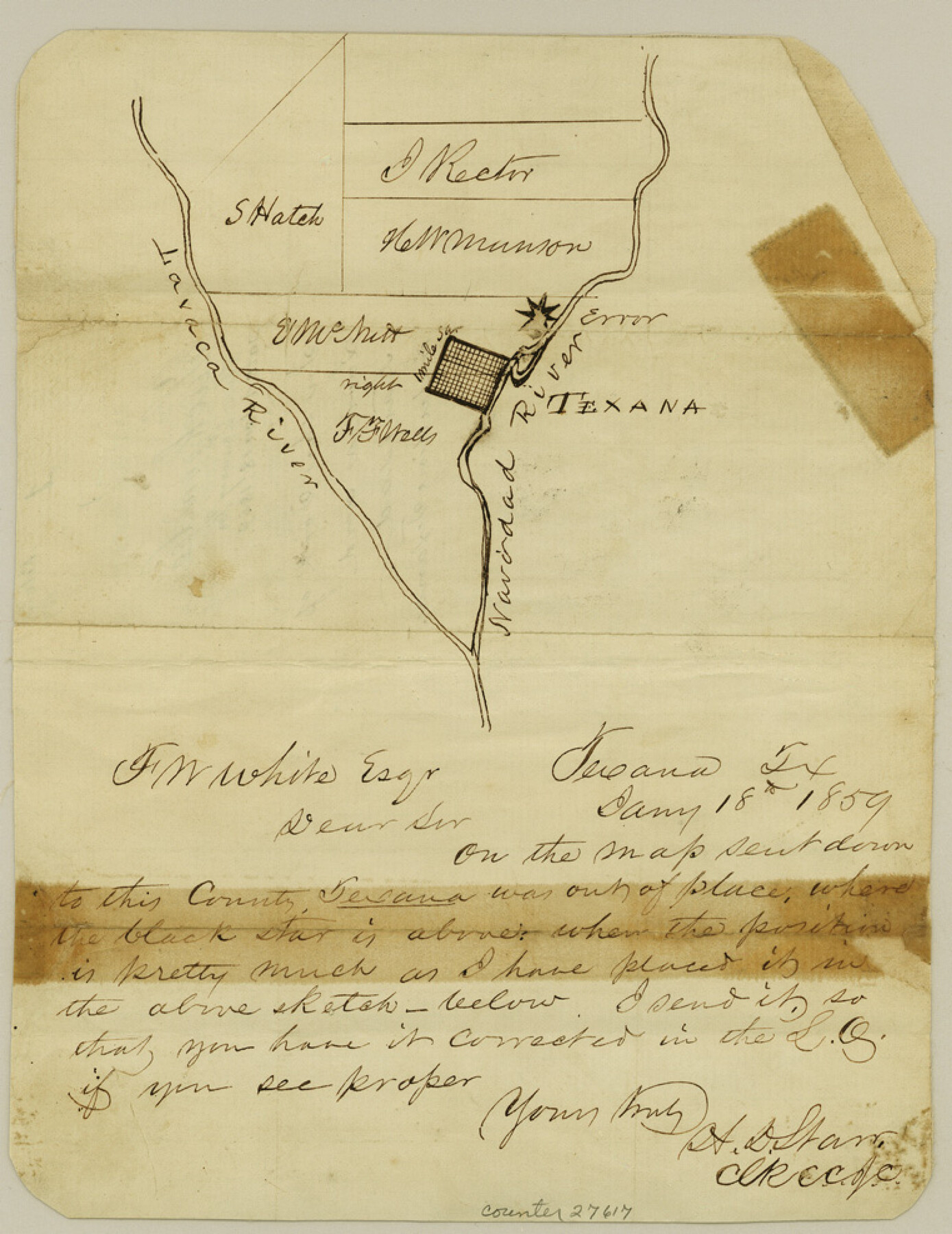
Jackson County Sketch File 1
[Sketches in the fork of Lavaca and Navidad Rivers, including Texana]
-
Map/Doc
27617
-
Collection
General Map Collection
-
Object Dates
1859/1/18 (Creation Date)
-
People and Organizations
H.D. Starr (Surveyor/Engineer)
-
Counties
Jackson
-
Subjects
Surveying Sketch File
-
Height x Width
9.9 x 7.6 inches
25.1 x 19.3 cm
-
Medium
paper, manuscript
-
Features
Navidad River
Texana
Lavaca River
Part of: General Map Collection
[Sketch for Mineral Application 16696-16697, Pecos River]
![65612, [Sketch for Mineral Application 16696-16697, Pecos River], General Map Collection](https://historictexasmaps.com/wmedia_w700/maps/65612-1.tif.jpg)
Print $40.00
- Digital $50.00
[Sketch for Mineral Application 16696-16697, Pecos River]
Size 37.4 x 74.9 inches
Map/Doc 65612
Nacogdoches County Working Sketch 13

Print $20.00
- Digital $50.00
Nacogdoches County Working Sketch 13
1912
Size 22.6 x 26.5 inches
Map/Doc 67086
Sutton County Sketch File 38

Print $20.00
- Digital $50.00
Sutton County Sketch File 38
1935
Size 18.2 x 28.3 inches
Map/Doc 12388
Kinney County Sketch File 35

Print $6.00
- Digital $50.00
Kinney County Sketch File 35
1944
Size 14.2 x 8.7 inches
Map/Doc 29185
Map of Winkler County

Print $20.00
- Digital $50.00
Map of Winkler County
1901
Size 43.1 x 36.6 inches
Map/Doc 4158
Carson County Sketch File 4

Print $4.00
- Digital $50.00
Carson County Sketch File 4
1901
Size 9.7 x 6.2 inches
Map/Doc 17351
Ochiltree County Boundary File 2

Print $4.00
- Digital $50.00
Ochiltree County Boundary File 2
Size 7.7 x 8.6 inches
Map/Doc 57675
Clay County Boundary File 6

Print $2.00
- Digital $50.00
Clay County Boundary File 6
Size 8.1 x 3.5 inches
Map/Doc 51376
Southern Pacific Transportation Company Right of Way and Track Map - Main Line

Print $40.00
- Digital $50.00
Southern Pacific Transportation Company Right of Way and Track Map - Main Line
1918
Size 25.4 x 57.6 inches
Map/Doc 82858
Red River County Sketch File 4

Print $6.00
- Digital $50.00
Red River County Sketch File 4
Size 9.3 x 11.5 inches
Map/Doc 35100
Blanco County Working Sketch 31

Print $20.00
- Digital $50.00
Blanco County Working Sketch 31
1972
Size 19.1 x 25.7 inches
Map/Doc 67391
Travis County Sketch File 58

Print $14.00
- Digital $50.00
Travis County Sketch File 58
1948
Size 11.4 x 8.9 inches
Map/Doc 38406
You may also like
St. L. S-W. Ry. of Texas Map of Lufkin Branch in Cherokee County Texas

Print $40.00
- Digital $50.00
St. L. S-W. Ry. of Texas Map of Lufkin Branch in Cherokee County Texas
1912
Size 23.4 x 121.6 inches
Map/Doc 64016
Fisher County Sketch File 9

Print $4.00
- Digital $50.00
Fisher County Sketch File 9
1893
Size 11.1 x 8.5 inches
Map/Doc 22575
Dimmit County Rolled Sketch 9

Print $20.00
- Digital $50.00
Dimmit County Rolled Sketch 9
1941
Size 37.8 x 39.3 inches
Map/Doc 8796
Gonzales County Working Sketch 2

Print $20.00
- Digital $50.00
Gonzales County Working Sketch 2
1920
Size 17.6 x 21.5 inches
Map/Doc 63217
Flight Mission No. CUG-3P, Frame 95, Kleberg County

Print $20.00
- Digital $50.00
Flight Mission No. CUG-3P, Frame 95, Kleberg County
1956
Size 18.4 x 22.3 inches
Map/Doc 86265
Matagorda County Working Sketch 8

Print $20.00
- Digital $50.00
Matagorda County Working Sketch 8
1953
Size 22.3 x 29.0 inches
Map/Doc 70866
Flight Mission No. DIX-7P, Frame 14, Aransas County

Print $20.00
- Digital $50.00
Flight Mission No. DIX-7P, Frame 14, Aransas County
1956
Size 18.8 x 22.6 inches
Map/Doc 83866
Kimble County Working Sketch 22

Print $20.00
- Digital $50.00
Kimble County Working Sketch 22
1929
Size 25.2 x 21.1 inches
Map/Doc 70090
[Map of Hunt County]
![3691, [Map of Hunt County], General Map Collection](https://historictexasmaps.com/wmedia_w700/maps/3691-1.tif.jpg)
Print $20.00
- Digital $50.00
[Map of Hunt County]
1851
Size 21.6 x 19.1 inches
Map/Doc 3691
Medina County

Print $40.00
- Digital $50.00
Medina County
1915
Size 50.0 x 42.0 inches
Map/Doc 66925
Gulf Coast of the United States, Key West to Rio Grande

Print $20.00
- Digital $50.00
Gulf Coast of the United States, Key West to Rio Grande
1863
Size 27.4 x 18.3 inches
Map/Doc 72666
Hidalgo County Sketch File 7

Print $20.00
- Digital $50.00
Hidalgo County Sketch File 7
1882
Size 20.3 x 28.2 inches
Map/Doc 11761