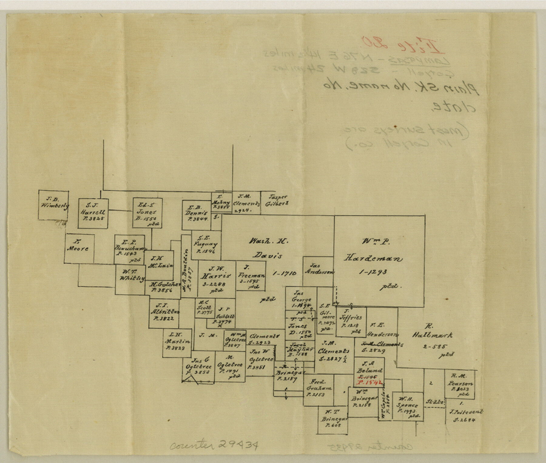
Lampasas County Sketch File 20
[Sketch of area around the Wash. H. Davis and Wm. P. Hardeman surveys mostly in Coryell County]
-
Map/Doc
29434
-
Collection
General Map Collection
-
Counties
Lampasas Coryell
-
Subjects
Surveying Sketch File
-
Height x Width
7.4 x 8.7 inches
18.8 x 22.1 cm
-
Medium
paper, manuscript
Part of: General Map Collection
Motley County Sketch File 11 (N)

Print $14.00
- Digital $50.00
Motley County Sketch File 11 (N)
1900
Size 11.1 x 8.6 inches
Map/Doc 32036
Bosque County Boundary File 11

Print $10.00
- Digital $50.00
Bosque County Boundary File 11
Size 8.8 x 7.0 inches
Map/Doc 50689
Llano County Sketch File 4

Print $6.00
- Digital $50.00
Llano County Sketch File 4
1869
Size 12.4 x 8.0 inches
Map/Doc 30353
Bastrop County Boundary File 6

Print $20.00
- Digital $50.00
Bastrop County Boundary File 6
Size 8.8 x 7.9 inches
Map/Doc 50337
Crockett County Rolled Sketch 76

Print $20.00
- Digital $50.00
Crockett County Rolled Sketch 76
1950
Size 24.6 x 26.1 inches
Map/Doc 5617
North Part of El Paso Co.

Print $20.00
- Digital $50.00
North Part of El Paso Co.
1977
Size 30.5 x 40.5 inches
Map/Doc 77273
Harris County Rolled Sketch 99

Print $20.00
- Digital $50.00
Harris County Rolled Sketch 99
1985
Size 16.2 x 20.2 inches
Map/Doc 6137
Flight Mission No. BRA-7M, Frame 147, Jefferson County

Print $20.00
- Digital $50.00
Flight Mission No. BRA-7M, Frame 147, Jefferson County
1953
Size 16.2 x 15.9 inches
Map/Doc 85541
Wise County Sketch File 5

Print $6.00
- Digital $50.00
Wise County Sketch File 5
1856
Size 8.2 x 14.0 inches
Map/Doc 40531
Maverick County Sketch File 4

Print $4.00
- Digital $50.00
Maverick County Sketch File 4
1876
Size 9.1 x 8.2 inches
Map/Doc 31051
State of Texas, Plate 1: Surface-Water Development, Exisiting Reservoirs and Reservoir Sites

Print $20.00
- Digital $50.00
State of Texas, Plate 1: Surface-Water Development, Exisiting Reservoirs and Reservoir Sites
1984
Size 17.8 x 18.1 inches
Map/Doc 3128
Delta County Sketch File 6

Print $20.00
- Digital $50.00
Delta County Sketch File 6
Size 18.3 x 22.4 inches
Map/Doc 11310
You may also like
Map of South Louisiana and Louisiana Continental Shelf showing Natural Gas Pipe Lines

Print $40.00
- Digital $50.00
Map of South Louisiana and Louisiana Continental Shelf showing Natural Gas Pipe Lines
Size 40.0 x 56.0 inches
Map/Doc 75906
Flight Mission No. DAG-17K, Frame 143, Matagorda County

Print $20.00
- Digital $50.00
Flight Mission No. DAG-17K, Frame 143, Matagorda County
1952
Size 16.4 x 16.4 inches
Map/Doc 86360

Denton County Working Sketch 16

Print $20.00
- Digital $50.00
Denton County Working Sketch 16
1973
Size 31.5 x 39.1 inches
Map/Doc 68621
Briscoe County Sketch File 2a

Print $4.00
- Digital $50.00
Briscoe County Sketch File 2a
Size 6.2 x 7.1 inches
Map/Doc 16415
Dallas County Sketch File 10

Print $4.00
- Digital $50.00
Dallas County Sketch File 10
1858
Size 12.5 x 8.2 inches
Map/Doc 20414
Nueces County NRC Article 33.136 Location Key Sheet

Print $20.00
- Digital $50.00
Nueces County NRC Article 33.136 Location Key Sheet
1975
Size 27.0 x 23.0 inches
Map/Doc 77031
Johnson County Rolled Sketch 4

Print $20.00
- Digital $50.00
Johnson County Rolled Sketch 4
Size 24.8 x 36.0 inches
Map/Doc 94047
Culberson County Sketch File 18

Print $8.00
- Digital $50.00
Culberson County Sketch File 18
Size 14.3 x 8.8 inches
Map/Doc 20185
Flight Mission No. CRK-5P, Frame 158, Refugio County

Print $20.00
- Digital $50.00
Flight Mission No. CRK-5P, Frame 158, Refugio County
1956
Size 18.6 x 22.5 inches
Map/Doc 86939
Crockett County Sketch File 40

Print $20.00
- Digital $50.00
Crockett County Sketch File 40
Size 16.8 x 37.9 inches
Map/Doc 11222
Galveston County Rolled Sketch V

Print $20.00
- Digital $50.00
Galveston County Rolled Sketch V
1934
Size 38.7 x 30.3 inches
Map/Doc 5992