Lamar County Sketch File 9
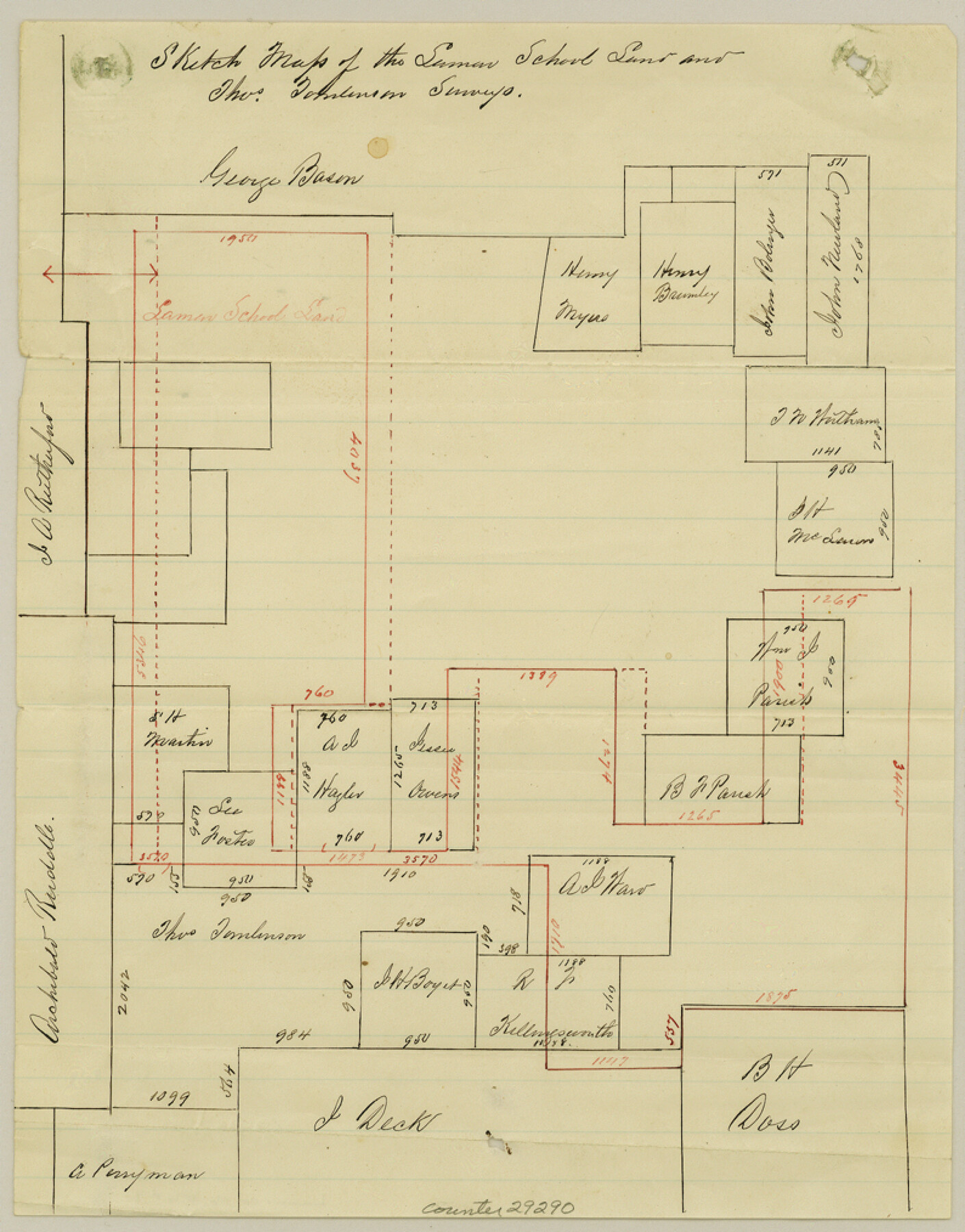
[Explanation and sketch map of the Lamar County School Land and T. Tomlinson surveys in the northwest part of county]
-
Map/Doc
29290
-
Collection
General Map Collection
-
Object Dates
7/27/1872 (Creation Date)
8/7/1872 (File Date)
-
People and Organizations
Thomas J. Wood (Surveyor/Engineer)
-
Counties
Lamar
-
Subjects
Surveying Sketch File
-
Height x Width
10.1 x 7.9 inches
25.7 x 20.1 cm
-
Medium
paper, manuscript
Part of: General Map Collection
Lamar County State Real Property Sketch 1

Print $20.00
- Digital $50.00
Lamar County State Real Property Sketch 1
2013
Size 24.0 x 36.0 inches
Map/Doc 93657
Nolan County Boundary File 2

Print $52.00
- Digital $50.00
Nolan County Boundary File 2
Size 8.7 x 8.1 inches
Map/Doc 57649
Cameron County

Print $20.00
- Digital $50.00
Cameron County
1913
Size 29.8 x 33.9 inches
Map/Doc 66746
University Lands Blocks 21 to 26, Pecos County, Texas

Print $20.00
- Digital $50.00
University Lands Blocks 21 to 26, Pecos County, Texas
1939
Size 46.1 x 36.8 inches
Map/Doc 2416
Texas Gulf Coast Map from the Sabine River to the Rio Grande as subdivided for mineral development

Print $40.00
- Digital $50.00
Texas Gulf Coast Map from the Sabine River to the Rio Grande as subdivided for mineral development
1948
Size 49.2 x 73.7 inches
Map/Doc 2905
Colorado River, Carancahua Sheet

Print $20.00
- Digital $50.00
Colorado River, Carancahua Sheet
1940
Size 30.7 x 38.0 inches
Map/Doc 65320
Webb County Rolled Sketch 68

Print $43.00
- Digital $50.00
Webb County Rolled Sketch 68
1910
Size 9.6 x 15.1 inches
Map/Doc 49485
Hansford County Working Sketch 4

Print $20.00
- Digital $50.00
Hansford County Working Sketch 4
1940
Size 27.6 x 25.4 inches
Map/Doc 63376
Upton County Working Sketch 21

Print $20.00
- Digital $50.00
Upton County Working Sketch 21
1950
Size 33.8 x 36.0 inches
Map/Doc 69517
Flight Mission No. BRA-16M, Frame 67, Jefferson County

Print $20.00
- Digital $50.00
Flight Mission No. BRA-16M, Frame 67, Jefferson County
1953
Size 18.6 x 22.4 inches
Map/Doc 85684
Atascosa County Sketch File 36

Print $20.00
- Digital $50.00
Atascosa County Sketch File 36
1947
Size 16.0 x 22.3 inches
Map/Doc 10867
Blanco County Sketch File 18

Print $4.00
- Digital $50.00
Blanco County Sketch File 18
1877
Size 12.6 x 8.5 inches
Map/Doc 14594
You may also like
[Tex Mex & CCSDRG&G Railroad Blocks in Starr and Hidalgo Counties, Texas]
![4452, [Tex Mex & CCSDRG&G Railroad Blocks in Starr and Hidalgo Counties, Texas], Maddox Collection](https://historictexasmaps.com/wmedia_w700/maps/4452-1.tif.jpg)
Print $20.00
- Digital $50.00
[Tex Mex & CCSDRG&G Railroad Blocks in Starr and Hidalgo Counties, Texas]
1906
Size 28.7 x 24.2 inches
Map/Doc 4452
Flight Mission No. CUG-2P, Frame 59, Kleberg County

Print $20.00
- Digital $50.00
Flight Mission No. CUG-2P, Frame 59, Kleberg County
1956
Size 18.4 x 22.1 inches
Map/Doc 86196
Intracoastal Waterway, Houma, LA to Corpus Christi, TX

Print $4.00
- Digital $50.00
Intracoastal Waterway, Houma, LA to Corpus Christi, TX
Size 23.8 x 22.0 inches
Map/Doc 61910
Explorations of the Louisiana Purchase

Explorations of the Louisiana Purchase
2023
Size 8.5 x 11.0 inches
Map/Doc 97183

Treaty to Resolve Pending Boundary Differences and Maintain the Rio Grande and Colorado River as the International Boundary Between the United States of American and Mexico

Print $4.00
- Digital $50.00
Treaty to Resolve Pending Boundary Differences and Maintain the Rio Grande and Colorado River as the International Boundary Between the United States of American and Mexico
1970
Size 12.1 x 19.0 inches
Map/Doc 83099
Map of a part of Laguna Madre in Willacy & Cameron Counties showing subdivision for mineral development

Print $20.00
- Digital $50.00
Map of a part of Laguna Madre in Willacy & Cameron Counties showing subdivision for mineral development
1950
Size 46.9 x 37.0 inches
Map/Doc 3097
Potter County Working Sketch 7

Print $20.00
- Digital $50.00
Potter County Working Sketch 7
1960
Size 18.4 x 37.4 inches
Map/Doc 71667
Real County Working Sketch 10

Print $20.00
- Digital $50.00
Real County Working Sketch 10
1929
Size 23.0 x 15.4 inches
Map/Doc 71902
Ector County Working Sketch Graphic Index - sheet B

Print $20.00
- Digital $50.00
Ector County Working Sketch Graphic Index - sheet B
1943
Size 44.6 x 38.5 inches
Map/Doc 76531
Bosque County Working Sketch Graphic Index

Print $20.00
- Digital $50.00
Bosque County Working Sketch Graphic Index
1945
Size 46.9 x 36.5 inches
Map/Doc 76469
Oldham County Sketch File 14

Print $20.00
- Digital $50.00
Oldham County Sketch File 14
1904
Size 20.0 x 24.6 inches
Map/Doc 12115