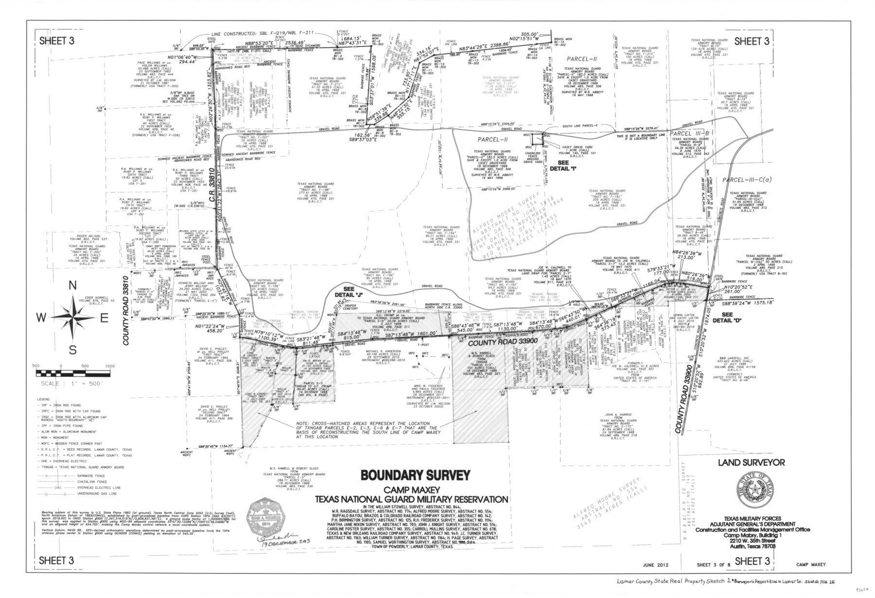
Lamar County State Real Property Sketch 1
Boundary Survey, Camp Maxey Texas National Guard Military Reservation
-
Map/Doc
93657
-
Collection
General Map Collection
-
Object Dates
2013/12/19 (Creation Date)
2014/1/31 (File Date)
-
People and Organizations
David A. Rolbiecki (Surveyor/Engineer)
-
Counties
Lamar
-
Subjects
State Real Property
-
Height x Width
24.0 x 36.0 inches
61.0 x 91.4 cm
-
Comments
See Lamar County Sketch File 16 (# 93654) for accompanying Surveyor's Report.
Related maps
Lamar County Sketch File 16

Print $166.00
- Digital $50.00
Lamar County Sketch File 16
2013
Size 11.0 x 8.5 inches
Map/Doc 93654
Part of: General Map Collection
Pecos County Rolled Sketch 134

Print $20.00
- Digital $50.00
Pecos County Rolled Sketch 134
1952
Size 35.9 x 27.0 inches
Map/Doc 7270
Presidio County Sketch File 110

Print $12.00
- Digital $50.00
Presidio County Sketch File 110
1886
Size 12.3 x 8.5 inches
Map/Doc 34818
Hall County Sketch File 34

Print $6.00
- Digital $50.00
Hall County Sketch File 34
1913
Size 15.1 x 9.5 inches
Map/Doc 24882
[Gulf, Colorado & Santa Fe]
![64592, [Gulf, Colorado & Santa Fe], General Map Collection](https://historictexasmaps.com/wmedia_w700/maps/64592.tif.jpg)
Print $40.00
- Digital $50.00
[Gulf, Colorado & Santa Fe]
1918
Size 33.2 x 110.5 inches
Map/Doc 64592
Tom Green County Sketch File 87

Print $5.00
- Digital $50.00
Tom Green County Sketch File 87
1951
Size 8.7 x 11.2 inches
Map/Doc 38264
Jefferson County Rolled Sketch 7

Print $20.00
- Digital $50.00
Jefferson County Rolled Sketch 7
1928
Size 30.8 x 34.2 inches
Map/Doc 9272
Hamilton County Working Sketch 5

Print $20.00
- Digital $50.00
Hamilton County Working Sketch 5
1941
Size 25.5 x 20.1 inches
Map/Doc 63343
Crockett County Rolled Sketch 43

Print $40.00
- Digital $50.00
Crockett County Rolled Sketch 43
1937
Size 31.4 x 63.2 inches
Map/Doc 8708
Collingsworth County Rolled Sketch 1

Print $40.00
- Digital $50.00
Collingsworth County Rolled Sketch 1
1941
Size 54.2 x 24.0 inches
Map/Doc 9664
Galveston County NRC Article 33.136 Sketch 69

Print $76.00
- Digital $50.00
Galveston County NRC Article 33.136 Sketch 69
2012
Size 24.0 x 36.0 inches
Map/Doc 94669
Sabine County Working Sketch 13

Print $20.00
- Digital $50.00
Sabine County Working Sketch 13
1935
Size 35.3 x 44.2 inches
Map/Doc 63684
Morris County Rolled Sketch 2A

Print $20.00
- Digital $50.00
Morris County Rolled Sketch 2A
Size 24.0 x 18.8 inches
Map/Doc 10252
You may also like
Somervell County

Print $20.00
- Digital $50.00
Somervell County
1941
Size 29.2 x 27.1 inches
Map/Doc 95642
Erforschung von Nordwest-Texas

Print $20.00
- Digital $50.00
Erforschung von Nordwest-Texas
Size 11.4 x 9.4 inches
Map/Doc 95144
Crockett County Working Sketch 41

Print $20.00
- Digital $50.00
Crockett County Working Sketch 41
1928
Size 20.4 x 23.2 inches
Map/Doc 68374
[Map Showing Panhandle Counties in Texas]
![2087, [Map Showing Panhandle Counties in Texas], General Map Collection](https://historictexasmaps.com/wmedia_w700/maps/2087.tif.jpg)
Print $20.00
- Digital $50.00
[Map Showing Panhandle Counties in Texas]
1876
Size 27.3 x 27.9 inches
Map/Doc 2087
Terrell County

Print $20.00
- Digital $50.00
Terrell County
1905
Size 40.5 x 32.3 inches
Map/Doc 4075
Gray County Working Sketch 1

Print $20.00
- Digital $50.00
Gray County Working Sketch 1
1957
Size 37.3 x 17.4 inches
Map/Doc 62196
Texas Hill Country Trail Region

Texas Hill Country Trail Region
2017
Size 18.2 x 24.3 inches
Map/Doc 96871
Flight Mission No. DIX-6P, Frame 114, Aransas County

Print $20.00
- Digital $50.00
Flight Mission No. DIX-6P, Frame 114, Aransas County
1956
Size 19.1 x 23.0 inches
Map/Doc 83820
The Land Grants of Texas

Print $20.00
The Land Grants of Texas
2014
Size 28.0 x 36.2 inches
Map/Doc 93698
Harris County Working Sketch 107

Print $20.00
- Digital $50.00
Harris County Working Sketch 107
1981
Size 46.0 x 28.1 inches
Map/Doc 65999
Map of McClennan County

Print $20.00
- Digital $50.00
Map of McClennan County
1868
Size 22.8 x 25.4 inches
Map/Doc 3861
Pecos County Working Sketch 83

Print $20.00
- Digital $50.00
Pecos County Working Sketch 83
1961
Size 18.7 x 28.7 inches
Map/Doc 71555