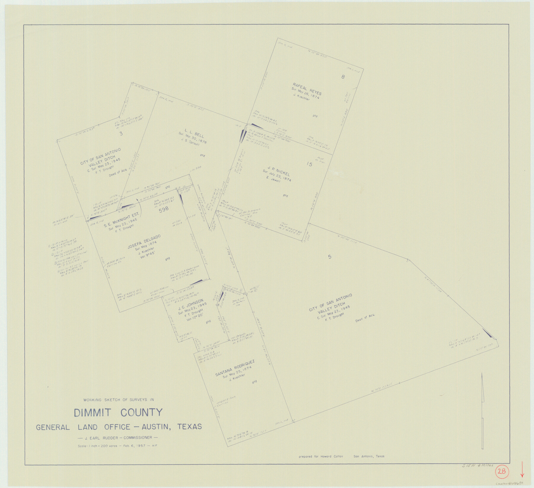
Dimmit County Working Sketch 28
-
Map/Doc
68689
-
Collection
General Map Collection
-
Object Dates
2/6/1957 (Creation Date)
-
People and Organizations
Herman Forbes (Draftsman)
-
Counties
Dimmit
-
Subjects
Surveying Working Sketch
-
Height x Width
25.5 x 27.9 inches
64.8 x 70.9 cm
-
Scale
1" = 200 varas
Part of: General Map Collection
[Maps of surveys in Reeves & Culberson Cos]
![61138, [Maps of surveys in Reeves & Culberson Cos], General Map Collection](https://historictexasmaps.com/wmedia_w700/maps/61138.tif.jpg)
Print $20.00
- Digital $50.00
[Maps of surveys in Reeves & Culberson Cos]
1937
Size 30.6 x 25.0 inches
Map/Doc 61138
Map of Nacogdoches County

Print $20.00
- Digital $50.00
Map of Nacogdoches County
1881
Size 24.0 x 21.4 inches
Map/Doc 4607
Upshur County Working Sketch 12

Print $20.00
- Digital $50.00
Upshur County Working Sketch 12
1984
Size 31.9 x 29.6 inches
Map/Doc 69569
Comal County Sketch File 4

Print $4.00
- Digital $50.00
Comal County Sketch File 4
Size 6.0 x 8.1 inches
Map/Doc 19004
Burleson County Working Sketch 14

Print $20.00
- Digital $50.00
Burleson County Working Sketch 14
1980
Size 24.6 x 18.9 inches
Map/Doc 67733
Bailey County

Print $40.00
- Digital $50.00
Bailey County
1956
Size 48.8 x 31.5 inches
Map/Doc 73074
Colton's Map of the United States of America

Print $20.00
- Digital $50.00
Colton's Map of the United States of America
1866
Size 21.3 x 36.7 inches
Map/Doc 93642
Map of Louisiana from D'Anville's Atlas

Print $20.00
- Digital $50.00
Map of Louisiana from D'Anville's Atlas
1788
Size 16.7 x 21.6 inches
Map/Doc 94111
Travis County Rolled Sketch 4

Print $20.00
- Digital $50.00
Travis County Rolled Sketch 4
1915
Size 19.7 x 35.6 inches
Map/Doc 8010
Pecos County Sketch File 69

Print $6.00
- Digital $50.00
Pecos County Sketch File 69
Size 11.1 x 8.8 inches
Map/Doc 33869
Dawson County Rolled Sketch 7
Print $20.00
- Digital $50.00
Dawson County Rolled Sketch 7
Size 14.1 x 38.1 inches
Map/Doc 5693
Galveston County NRC Article 33.136 Location Key Sheet

Print $20.00
- Digital $50.00
Galveston County NRC Article 33.136 Location Key Sheet
1994
Size 27.0 x 23.0 inches
Map/Doc 77018
You may also like
General Highway Map, Cameron County, Texas

Print $20.00
General Highway Map, Cameron County, Texas
1961
Size 18.3 x 24.7 inches
Map/Doc 79398
Brewster County Rolled Sketch 85

Print $20.00
- Digital $50.00
Brewster County Rolled Sketch 85
1946
Size 30.4 x 22.8 inches
Map/Doc 5246
King County Boundary File 4

Print $58.00
- Digital $50.00
King County Boundary File 4
Size 14.1 x 8.7 inches
Map/Doc 64905
Map of Lampasas County

Print $20.00
- Digital $50.00
Map of Lampasas County
1864
Size 20.5 x 24.8 inches
Map/Doc 3793
Original Town of Nadine, Lea County, New Mexico

Print $20.00
- Digital $50.00
Original Town of Nadine, Lea County, New Mexico
Size 27.1 x 33.5 inches
Map/Doc 92420
Webb County Working Sketch 37

Print $20.00
- Digital $50.00
Webb County Working Sketch 37
1940
Size 25.0 x 20.4 inches
Map/Doc 72402
Map of the upper surveys in Robertson's Colony Sold by the State of Coahuila and Texas

Print $20.00
- Digital $50.00
Map of the upper surveys in Robertson's Colony Sold by the State of Coahuila and Texas
Size 26.8 x 22.0 inches
Map/Doc 82
Shackelford County

Print $20.00
- Digital $50.00
Shackelford County
1920
Size 39.2 x 46.1 inches
Map/Doc 93031
Brewster County Working Sketch Graphic Index, North Part, Sheet 2 (Sketches 87 to Most Recent)

Print $20.00
- Digital $50.00
Brewster County Working Sketch Graphic Index, North Part, Sheet 2 (Sketches 87 to Most Recent)
1956
Size 41.8 x 39.5 inches
Map/Doc 76474
Tyler County Sketch File 14

Print $4.00
- Digital $50.00
Tyler County Sketch File 14
1857
Size 8.3 x 10.1 inches
Map/Doc 38656
[Surveys in the Bexar District along the Cibolo Creek]
![3168, [Surveys in the Bexar District along the Cibolo Creek], General Map Collection](https://historictexasmaps.com/wmedia_w700/maps/3168.tif.jpg)
Print $2.00
- Digital $50.00
[Surveys in the Bexar District along the Cibolo Creek]
1846
Size 5.1 x 6.7 inches
Map/Doc 3168
Map of Texas and Pacific Ry. Company's Surveys in the 80 Mile Reserve

Print $40.00
- Digital $50.00
Map of Texas and Pacific Ry. Company's Surveys in the 80 Mile Reserve
1885
Size 41.5 x 91.8 inches
Map/Doc 2300