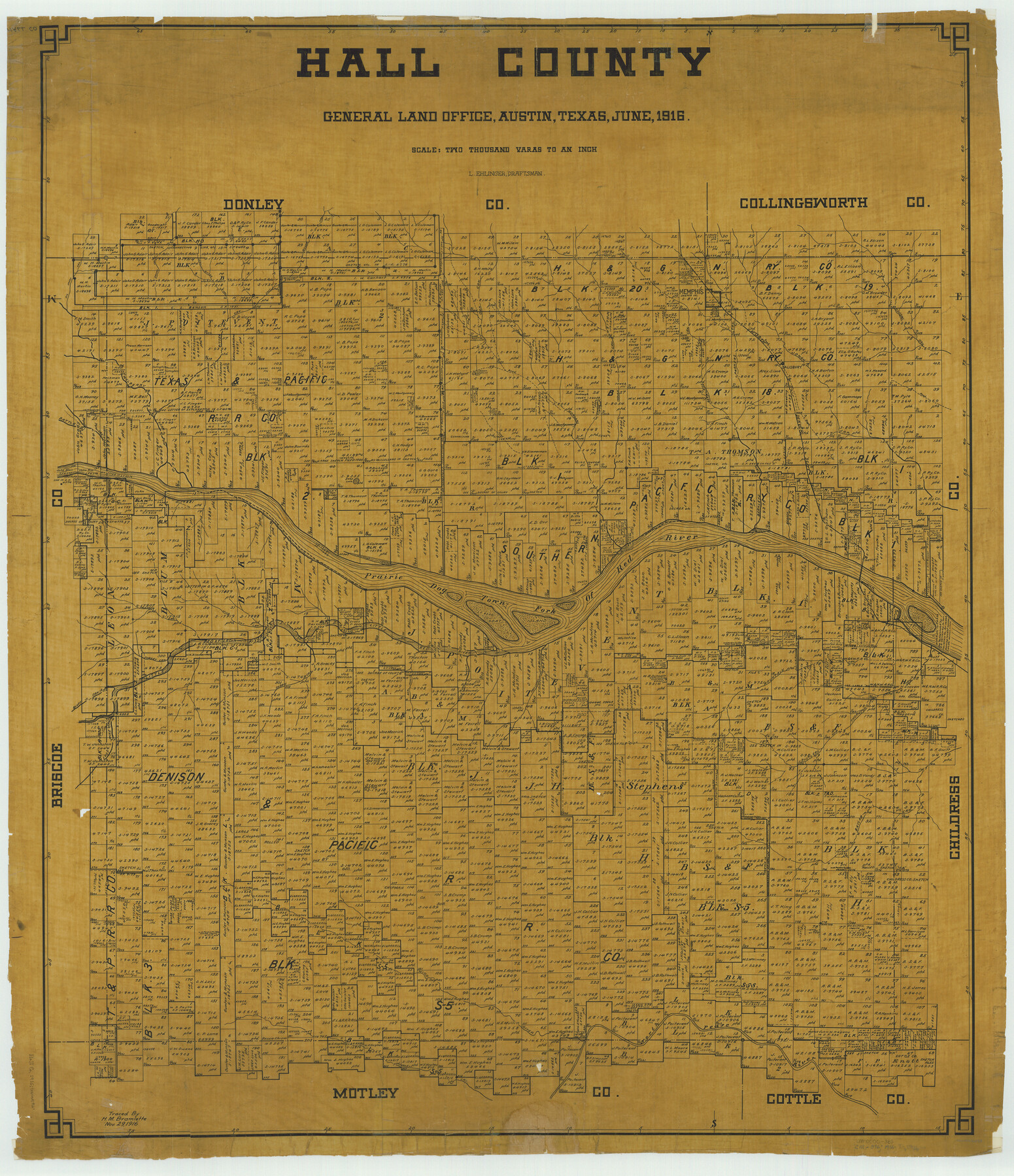
Hall County
-
Map/Doc
66848
-
Collection
General Map Collection
-
Object Dates
1916 (Creation Date)
-
People and Organizations
Texas General Land Office (Publisher)
L. Ehlinger (Draftsman)
L. Ehlinger (Compiler)
-
Counties
Hall
-
Subjects
County
-
Height x Width
43.0 x 37.0 inches
109.2 x 94.0 cm
-
Comments
Traced November 29, 1916 by H. M. Bramlette.
Part of: General Map Collection
Oldham County Sketch File 19

Print $20.00
- Digital $50.00
Oldham County Sketch File 19
1904
Size 18.2 x 24.0 inches
Map/Doc 12116
Flight Mission No. DQN-5K, Frame 48, Calhoun County

Print $20.00
- Digital $50.00
Flight Mission No. DQN-5K, Frame 48, Calhoun County
1953
Size 18.7 x 22.2 inches
Map/Doc 84393
Map of the Texas & Pacific Ry. Reserve West of the Pecos River

Print $20.00
- Digital $50.00
Map of the Texas & Pacific Ry. Reserve West of the Pecos River
1879
Size 40.8 x 30.2 inches
Map/Doc 65333
Menard County Working Sketch 4

Print $20.00
- Digital $50.00
Menard County Working Sketch 4
1914
Size 19.8 x 16.2 inches
Map/Doc 70951
Kendall County Working Sketch 28

Print $20.00
- Digital $50.00
Kendall County Working Sketch 28
1995
Size 36.0 x 37.2 inches
Map/Doc 70001
Bell County Working Sketch 20

Print $20.00
- Digital $50.00
Bell County Working Sketch 20
1996
Size 39.5 x 34.7 inches
Map/Doc 67360
Part of Laguna Madre from Mosquito Trangulation Station to Sand Triangulation Station

Print $40.00
- Digital $50.00
Part of Laguna Madre from Mosquito Trangulation Station to Sand Triangulation Station
1881
Size 34.5 x 54.6 inches
Map/Doc 73486
Coast Chart No. 210 Aransas Pass and Corpus Christi Bay with the coast to latitude 27° 12' Texas

Print $20.00
- Digital $50.00
Coast Chart No. 210 Aransas Pass and Corpus Christi Bay with the coast to latitude 27° 12' Texas
1887
Size 27.6 x 18.2 inches
Map/Doc 72789
Flight Mission No. DCL-7C, Frame 118, Kenedy County

Print $20.00
- Digital $50.00
Flight Mission No. DCL-7C, Frame 118, Kenedy County
1943
Size 18.4 x 22.3 inches
Map/Doc 86083
Tom Green County Sketch File 5

Print $42.00
- Digital $50.00
Tom Green County Sketch File 5
1849
Size 8.5 x 7.1 inches
Map/Doc 38167
Presidio County Rolled Sketch 146

Print $20.00
- Digital $50.00
Presidio County Rolled Sketch 146
2018
Size 29.8 x 41.8 inches
Map/Doc 95821
Gray County Rolled Sketch 3

Print $105.00
- Digital $50.00
Gray County Rolled Sketch 3
Size 10.6 x 15.5 inches
Map/Doc 45287
You may also like
General Highway Map, Cherokee County, Texas

Print $20.00
General Highway Map, Cherokee County, Texas
1961
Size 18.2 x 24.7 inches
Map/Doc 79406
Texas Intracoastal Waterway - Port O'Connor to San Antonio Bay, Including Pass Cavallo

Print $20.00
- Digital $50.00
Texas Intracoastal Waterway - Port O'Connor to San Antonio Bay, Including Pass Cavallo
1961
Size 26.5 x 38.7 inches
Map/Doc 73373
Treaty to Resolve Pending Boundary Differences and Maintain the Rio Grande and Colorado River as the International Boundary Between the United States of American and Mexico

Print $4.00
- Digital $50.00
Treaty to Resolve Pending Boundary Differences and Maintain the Rio Grande and Colorado River as the International Boundary Between the United States of American and Mexico
1970
Size 12.2 x 19.0 inches
Map/Doc 83100
Panhandle of Texas

Print $20.00
- Digital $50.00
Panhandle of Texas
1907
Size 11.4 x 14.4 inches
Map/Doc 95889
Bexar County Rolled Sketch 1

Print $20.00
- Digital $50.00
Bexar County Rolled Sketch 1
Size 23.1 x 26.2 inches
Map/Doc 5134
[Blocks H, Z, Rodriguez League, and vicinity]
![91174, [Blocks H, Z, Rodriguez League, and vicinity], Twichell Survey Records](https://historictexasmaps.com/wmedia_w700/maps/91174-1.tif.jpg)
Print $20.00
- Digital $50.00
[Blocks H, Z, Rodriguez League, and vicinity]
Size 20.5 x 26.1 inches
Map/Doc 91174
Bell County Working Sketch 10

Print $20.00
- Digital $50.00
Bell County Working Sketch 10
1954
Size 38.2 x 41.4 inches
Map/Doc 67350
![92161, [Block K], Twichell Survey Records](https://historictexasmaps.com/wmedia_w700/maps/92161-1.tif.jpg)
Entrance to Sabine Pass, Texas from survey of May and June 1892 under the direction of Major James B. Quinn, Corps of Engineers, USA

Print $20.00
- Digital $50.00
Entrance to Sabine Pass, Texas from survey of May and June 1892 under the direction of Major James B. Quinn, Corps of Engineers, USA
1892
Size 18.8 x 32.9 inches
Map/Doc 94154
Ward County Sketch File L

Print $20.00
- Digital $50.00
Ward County Sketch File L
Size 23.8 x 29.6 inches
Map/Doc 12601
Lee County Working Sketch 18

Print $20.00
- Digital $50.00
Lee County Working Sketch 18
1989
Size 18.3 x 17.2 inches
Map/Doc 70397
