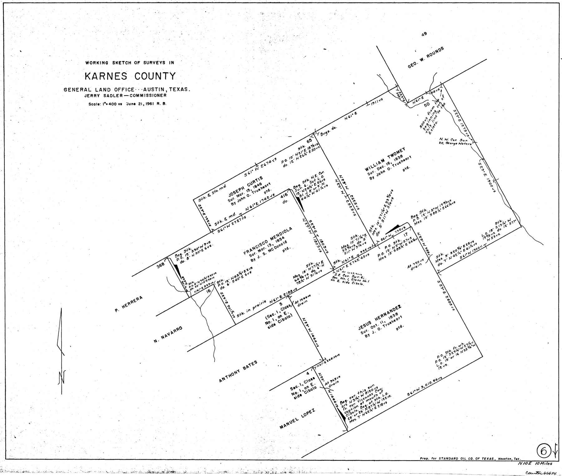
Karnes County Working Sketch 6
-
Map/Doc
66654
-
Collection
General Map Collection
-
Object Dates
6/21/1961 (Creation Date)
-
People and Organizations
Roy Buckholts (Draftsman)
-
Counties
Karnes
-
Subjects
Surveying Working Sketch
-
Height x Width
23.3 x 27.5 inches
59.2 x 69.9 cm
-
Scale
1" = 400 varas
Part of: General Map Collection
Milam County Working Sketch 15

Print $20.00
- Digital $50.00
Milam County Working Sketch 15
1911
Size 18.2 x 26.1 inches
Map/Doc 71030
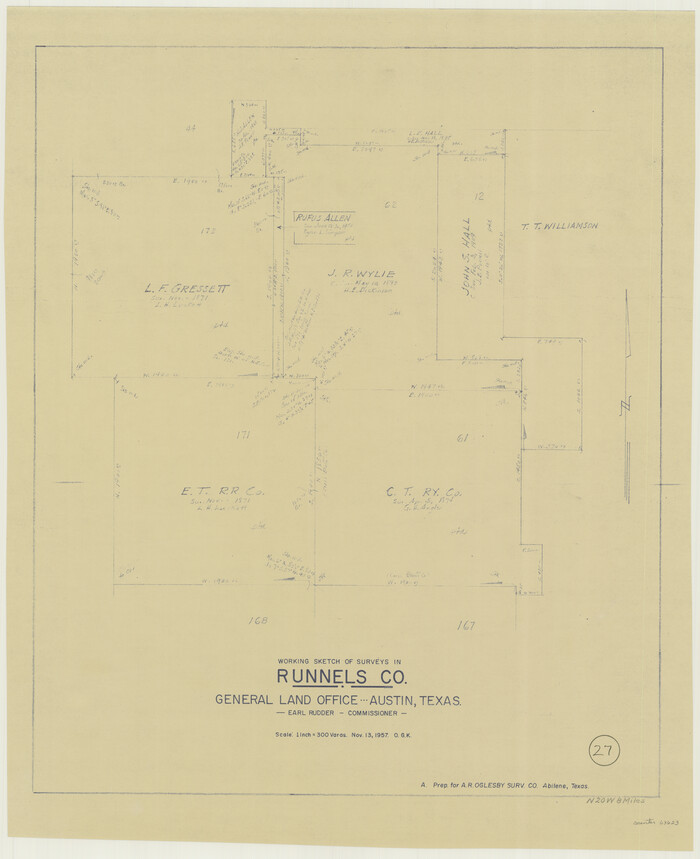
Runnels County Working Sketch 27
Print $20.00
- Digital $50.00
Runnels County Working Sketch 27
1957
Size 27.1 x 22.1 inches
Map/Doc 63623
Bee County Sketch File 22

Print $8.00
- Digital $50.00
Bee County Sketch File 22
1878
Size 10.0 x 8.0 inches
Map/Doc 14314
San Jacinto County Sketch File 24

Print $18.00
San Jacinto County Sketch File 24
2001
Size 14.5 x 8.9 inches
Map/Doc 35816
Henderson County Working Sketch 16

Print $40.00
- Digital $50.00
Henderson County Working Sketch 16
1937
Size 49.9 x 30.9 inches
Map/Doc 66149
Flight Mission No. BQR-3K, Frame 158, Brazoria County

Print $20.00
- Digital $50.00
Flight Mission No. BQR-3K, Frame 158, Brazoria County
1952
Size 18.7 x 22.4 inches
Map/Doc 83985
Gillespie County Boundary File 7

Print $18.00
- Digital $50.00
Gillespie County Boundary File 7
Size 8.6 x 4.0 inches
Map/Doc 53771
Baylor County Working Sketch 14

Print $40.00
- Digital $50.00
Baylor County Working Sketch 14
1982
Size 33.5 x 55.1 inches
Map/Doc 67299
Angelina County Sketch File 24

Print $8.00
- Digital $50.00
Angelina County Sketch File 24
1893
Size 8.9 x 5.6 inches
Map/Doc 13065
Duval County Sketch File B

Print $20.00
- Digital $50.00
Duval County Sketch File B
1880
Size 15.5 x 20.6 inches
Map/Doc 11412
El Paso County Sketch File 32

Print $8.00
- Digital $50.00
El Paso County Sketch File 32
1983
Size 14.3 x 8.9 inches
Map/Doc 22124
Dallas County Working Sketch 5

Print $20.00
- Digital $50.00
Dallas County Working Sketch 5
1941
Size 18.7 x 16.4 inches
Map/Doc 68571
You may also like
Edwards County Working Sketch 45

Print $40.00
- Digital $50.00
Edwards County Working Sketch 45
1950
Size 65.4 x 43.4 inches
Map/Doc 68921
[Parts of Blocks Z, L, M-21, M-15, and 46]
![91831, [Parts of Blocks Z, L, M-21, M-15, and 46], Twichell Survey Records](https://historictexasmaps.com/wmedia_w700/maps/91831-1.tif.jpg)
Print $20.00
- Digital $50.00
[Parts of Blocks Z, L, M-21, M-15, and 46]
Size 21.2 x 16.7 inches
Map/Doc 91831
Davis Mountains State Park Area Showing Scenic Drive

Print $20.00
Davis Mountains State Park Area Showing Scenic Drive
1935
Size 26.9 x 34.5 inches
Map/Doc 76312
Jackson County Sketch File 6

Print $4.00
- Digital $50.00
Jackson County Sketch File 6
1897
Size 13.1 x 8.9 inches
Map/Doc 27632
Flight Mission No. DAG-18K, Frame 180, Matagorda County

Print $20.00
- Digital $50.00
Flight Mission No. DAG-18K, Frame 180, Matagorda County
1952
Size 18.6 x 22.3 inches
Map/Doc 86372
Milam County Rolled Sketch 3A

Print $40.00
- Digital $50.00
Milam County Rolled Sketch 3A
1967
Size 49.5 x 43.3 inches
Map/Doc 9522
Chambers County Working Sketch 18

Print $20.00
- Digital $50.00
Chambers County Working Sketch 18
1965
Size 39.8 x 29.2 inches
Map/Doc 68001
Brooks County Working Sketch 2

Print $3.00
- Digital $50.00
Brooks County Working Sketch 2
Size 10.0 x 16.2 inches
Map/Doc 67786
General Highway Map, Randall County, Texas

Print $20.00
General Highway Map, Randall County, Texas
1961
Size 18.1 x 24.5 inches
Map/Doc 79635
Stonewall County Sketch File 30

Print $120.00
- Digital $50.00
Stonewall County Sketch File 30
1986
Size 24.5 x 35.3 inches
Map/Doc 12370
Isogonic Chart and Meridian Changes, University Land, Hudspeth County, Texas

Print $20.00
- Digital $50.00
Isogonic Chart and Meridian Changes, University Land, Hudspeth County, Texas
Size 28.5 x 34.1 inches
Map/Doc 62953
San Patricio County Rolled Sketch 53A-53C

Print $102.00
- Digital $50.00
San Patricio County Rolled Sketch 53A-53C
1996
Size 11.0 x 8.5 inches
Map/Doc 82862