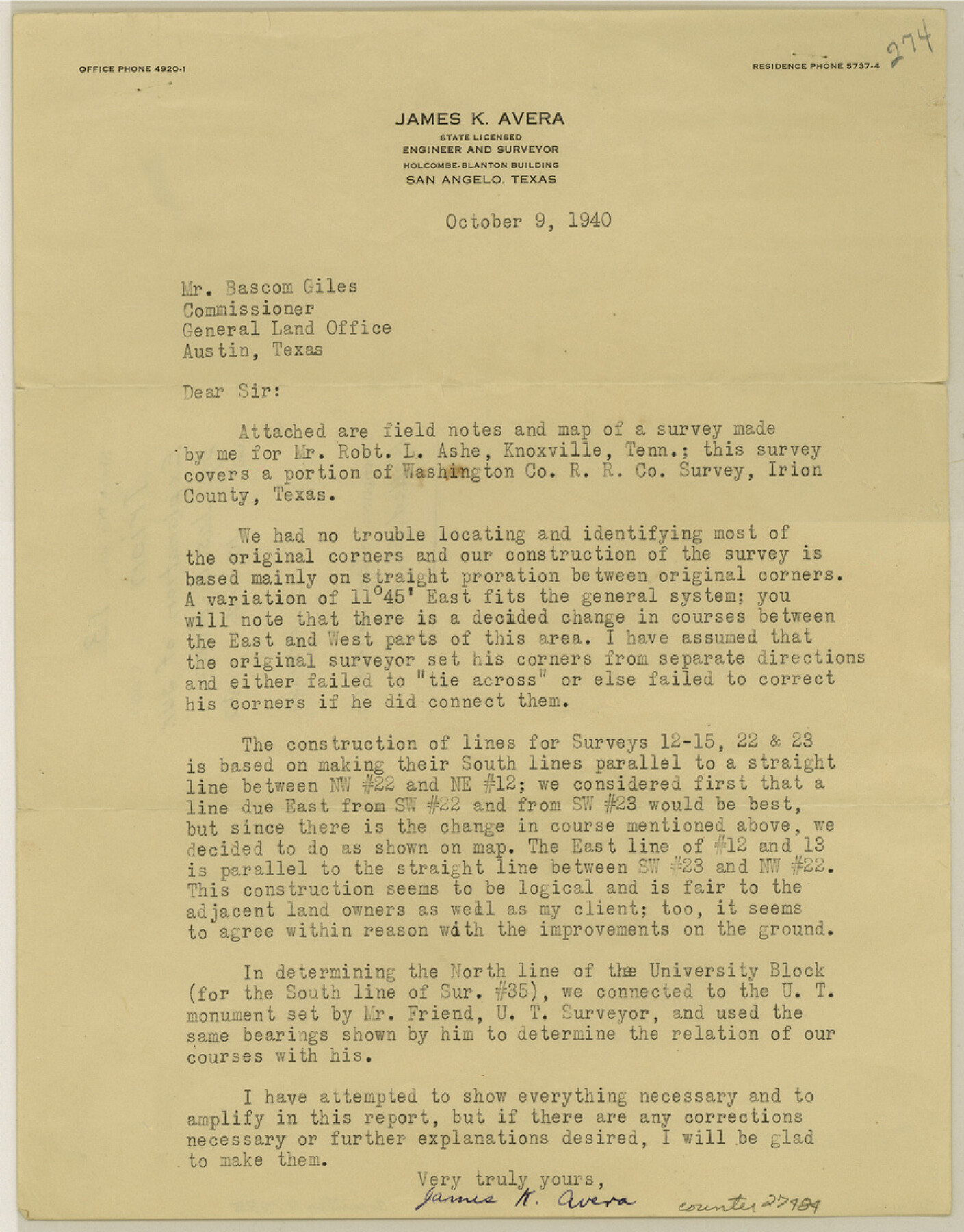
Irion County Sketch File 13
[Explanation of survey]
-
Map/Doc
27484
-
Collection
General Map Collection
-
Object Dates
1940/10/9 (Creation Date)
1940/10/14 (File Date)
-
People and Organizations
James K. Avera (Surveyor/Engineer)
-
Counties
Irion
-
Subjects
Surveying Sketch File
-
Height x Width
11.2 x 8.8 inches
28.5 x 22.4 cm
-
Medium
paper, print
Part of: General Map Collection
Loving County Working Sketch 12

Print $40.00
- Digital $50.00
Loving County Working Sketch 12
1957
Size 48.1 x 37.1 inches
Map/Doc 70645
Dallas County Sketch File 12

Print $20.00
- Digital $50.00
Dallas County Sketch File 12
1853
Size 25.4 x 25.2 inches
Map/Doc 11284
Webb County Rolled Sketch 8

Print $20.00
- Digital $50.00
Webb County Rolled Sketch 8
Size 26.7 x 19.2 inches
Map/Doc 8174
Hemphill County Rolled Sketch 15A

Print $20.00
- Digital $50.00
Hemphill County Rolled Sketch 15A
1961
Size 26.6 x 17.3 inches
Map/Doc 6195
Map of the State of Texas from the most recent authorities

Print $20.00
- Digital $50.00
Map of the State of Texas from the most recent authorities
1850
Size 13.8 x 17.3 inches
Map/Doc 89251
Harris County Working Sketch 61

Print $20.00
- Digital $50.00
Harris County Working Sketch 61
1954
Size 22.2 x 24.3 inches
Map/Doc 65953
San Augustine County Working Sketch 27

Print $20.00
- Digital $50.00
San Augustine County Working Sketch 27
2009
Size 30.4 x 31.3 inches
Map/Doc 89020
Armstrong County Sketch File 4

Print $40.00
- Digital $50.00
Armstrong County Sketch File 4
1887
Size 17.9 x 20.1 inches
Map/Doc 10840
Marion County Working Sketch 7

Print $20.00
- Digital $50.00
Marion County Working Sketch 7
1918
Size 27.9 x 27.7 inches
Map/Doc 70782

[Surveys along the Leona and Frio Rivers]
![16, [Surveys along the Leona and Frio Rivers], General Map Collection](https://historictexasmaps.com/wmedia_w700/maps/16.tif.jpg)
Print $20.00
- Digital $50.00
[Surveys along the Leona and Frio Rivers]
1841
Size 12.4 x 13.1 inches
Map/Doc 16
Webb County Sketch File 44b

Print $8.00
- Digital $50.00
Webb County Sketch File 44b
1936
Size 14.5 x 9.0 inches
Map/Doc 39829
You may also like
Armstrong County Sketch File A-12

Print $40.00
- Digital $50.00
Armstrong County Sketch File A-12
Size 41.3 x 18.5 inches
Map/Doc 10374
The Military History of Texas Map!

The Military History of Texas Map!
1996
Size 24.2 x 35.1 inches
Map/Doc 96827
General Highway Map, La Salle County, Texas

Print $20.00
General Highway Map, La Salle County, Texas
1961
Size 18.2 x 24.8 inches
Map/Doc 79565
Brooks County Rolled Sketch 14

Print $20.00
- Digital $50.00
Brooks County Rolled Sketch 14
Size 28.4 x 32.8 inches
Map/Doc 5339
Lamar County Sketch File 11

Print $24.00
- Digital $50.00
Lamar County Sketch File 11
1934
Size 11.5 x 7.2 inches
Map/Doc 29295
Wm. H. Bush Estate Resurveyed by W. D. Twichell May 1905

Print $40.00
- Digital $50.00
Wm. H. Bush Estate Resurveyed by W. D. Twichell May 1905
1905
Size 37.1 x 57.7 inches
Map/Doc 89788
[Corpus Christi Bay, Padre Island, Mustang Island, Laguna de la Madre, King and Kenedy's Pasture]
![73047, [Corpus Christi Bay, Padre Island, Mustang Island, Laguna de la Madre, King and Kenedy's Pasture], General Map Collection](https://historictexasmaps.com/wmedia_w700/maps/73047.tif.jpg)
Print $20.00
- Digital $50.00
[Corpus Christi Bay, Padre Island, Mustang Island, Laguna de la Madre, King and Kenedy's Pasture]
Size 18.2 x 26.0 inches
Map/Doc 73047
Harris County Aerial Photograph Index Sheet 10

Print $20.00
- Digital $50.00
Harris County Aerial Photograph Index Sheet 10
1953
Size 22.1 x 16.9 inches
Map/Doc 83704
Presidio County Sketch File 40

Print $20.00
- Digital $50.00
Presidio County Sketch File 40
1912
Size 24.7 x 23.4 inches
Map/Doc 11715
Right of Way & Track Map, San Antonio & Aransas Pass Railway Co.

Print $40.00
- Digital $50.00
Right of Way & Track Map, San Antonio & Aransas Pass Railway Co.
1919
Size 25.3 x 56.7 inches
Map/Doc 64216
Trinity River, Waxahachie Sheet/Waxahachie Creek

Print $6.00
- Digital $50.00
Trinity River, Waxahachie Sheet/Waxahachie Creek
1931
Size 30.1 x 32.8 inches
Map/Doc 65237
Map of Zavalla County

Print $20.00
- Digital $50.00
Map of Zavalla County
1876
Size 22.5 x 33.2 inches
Map/Doc 4181