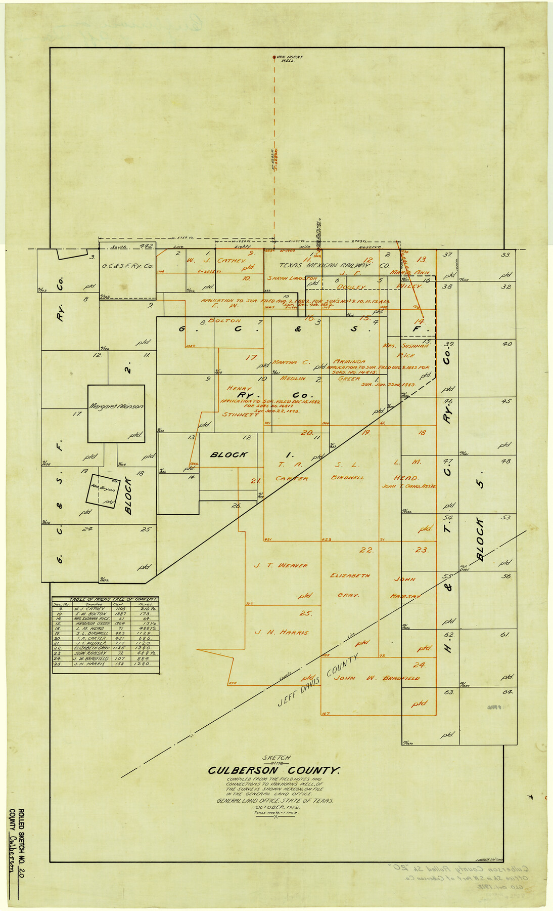
Culberson County Rolled Sketch 20
Sketch in Culberson County compiled from the field notes and connections to Van Horn's Well, of the surveys shown hereon, on file in the General Land Office
-
Map/Doc
5653
-
Collection
General Map Collection
-
Object Dates
1912 (Creation Date)
-
Counties
Culberson Jeff Davis
-
Subjects
Surveying Rolled Sketch
-
Height x Width
30.0 x 18.2 inches
76.2 x 46.2 cm
-
Medium
linen, manuscript
-
Scale
1" = 1000 varas
Part of: General Map Collection
McMullen County Sketch File 30

Print $20.00
- Digital $50.00
McMullen County Sketch File 30
1884
Size 38.5 x 21.1 inches
Map/Doc 10540

Flight Mission No. BRA-7M, Frame 30, Jefferson County

Print $20.00
- Digital $50.00
Flight Mission No. BRA-7M, Frame 30, Jefferson County
1953
Size 18.6 x 22.3 inches
Map/Doc 85481
Right of Way and Track Map, the Missouri, Kansas and Texas Ry. of Texas - Henrietta Division

Print $20.00
- Digital $50.00
Right of Way and Track Map, the Missouri, Kansas and Texas Ry. of Texas - Henrietta Division
1918
Size 11.9 x 26.8 inches
Map/Doc 64753
Map and Profile No. 1 from the Red River to the Rio Grande; from explorations and surveys made under the direction of the Hon. Jefferson Davis, Secretary of War by Captain John Pope, Corps. Topl Engrs.

Print $40.00
- Digital $50.00
Map and Profile No. 1 from the Red River to the Rio Grande; from explorations and surveys made under the direction of the Hon. Jefferson Davis, Secretary of War by Captain John Pope, Corps. Topl Engrs.
Size 30.2 x 59.9 inches
Map/Doc 95176
Upton County Rolled Sketch 14

Print $20.00
- Digital $50.00
Upton County Rolled Sketch 14
Size 43.2 x 32.0 inches
Map/Doc 10038
Right of Way & Track Map San Antonio & Aransas Pass Railway Co.

Print $40.00
- Digital $50.00
Right of Way & Track Map San Antonio & Aransas Pass Railway Co.
1919
Size 25.3 x 56.5 inches
Map/Doc 64024
Flight Mission No. DIX-6P, Frame 111, Aransas County

Print $20.00
- Digital $50.00
Flight Mission No. DIX-6P, Frame 111, Aransas County
1956
Size 18.9 x 22.6 inches
Map/Doc 83817
Flight Mission No. BRA-7M, Frame 40, Jefferson County

Print $20.00
- Digital $50.00
Flight Mission No. BRA-7M, Frame 40, Jefferson County
1953
Size 18.7 x 22.3 inches
Map/Doc 85491
Galveston Bay and Approaches

Print $20.00
- Digital $50.00
Galveston Bay and Approaches
1966
Size 43.3 x 32.6 inches
Map/Doc 69879
Erath County Working Sketch 22

Print $20.00
- Digital $50.00
Erath County Working Sketch 22
1965
Size 29.8 x 36.8 inches
Map/Doc 69103
Right of Way and Track Map of The Missouri, Kansas & Texas Railway of Texas

Print $40.00
- Digital $50.00
Right of Way and Track Map of The Missouri, Kansas & Texas Railway of Texas
1918
Size 24.4 x 50.7 inches
Map/Doc 64538
You may also like
Robertson County Working Sketch 18

Print $20.00
- Digital $50.00
Robertson County Working Sketch 18
1995
Size 29.9 x 34.1 inches
Map/Doc 63591
Matagorda County Sketch File 44

Print $37.00
- Digital $50.00
Matagorda County Sketch File 44
Size 11.2 x 8.8 inches
Map/Doc 77096
Blanco County Working Sketch 6b

Print $40.00
- Digital $50.00
Blanco County Working Sketch 6b
1930
Size 52.6 x 27.8 inches
Map/Doc 67366
Maps of Gulf Intracoastal Waterway, Texas - Sabine River to the Rio Grande and connecting waterways including ship channels

Print $20.00
- Digital $50.00
Maps of Gulf Intracoastal Waterway, Texas - Sabine River to the Rio Grande and connecting waterways including ship channels
1966
Size 14.5 x 22.4 inches
Map/Doc 61951
Kerr County Working Sketch 25

Print $20.00
- Digital $50.00
Kerr County Working Sketch 25
Size 21.5 x 28.5 inches
Map/Doc 70056
Collingsworth County, Texas

Print $20.00
- Digital $50.00
Collingsworth County, Texas
Size 18.3 x 16.6 inches
Map/Doc 465
Kinney County Working Sketch 27

Print $20.00
- Digital $50.00
Kinney County Working Sketch 27
1956
Size 23.1 x 25.1 inches
Map/Doc 70209
Kimble County Rolled Sketch 20

Print $20.00
- Digital $50.00
Kimble County Rolled Sketch 20
Size 14.6 x 18.1 inches
Map/Doc 6511
Harris County NRC Article 33.136 Sketch 16

Print $20.00
- Digital $50.00
Harris County NRC Article 33.136 Sketch 16
2006
Size 24.0 x 36.0 inches
Map/Doc 94823
Hopkins County Sketch File 22

Print $4.00
- Digital $50.00
Hopkins County Sketch File 22
1870
Size 10.2 x 8.1 inches
Map/Doc 26730
Clay County Boundary File 13

Print $48.00
- Digital $50.00
Clay County Boundary File 13
Size 10.6 x 9.1 inches
Map/Doc 51410
Webb County Rolled Sketch 42

Print $20.00
- Digital $50.00
Webb County Rolled Sketch 42
1941
Size 25.2 x 37.1 inches
Map/Doc 8197