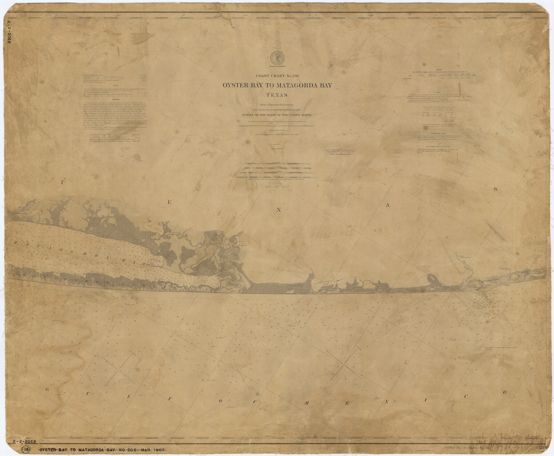
Coast Chart No. 106 - Oyster Bay to Matagorda Bay, Texas
K-2-206b
-
Map/Doc
69929
-
Collection
General Map Collection
-
Object Dates
1881 (Creation Date)
-
Counties
Brazoria Matagorda
-
Subjects
Nautical Charts
-
Height x Width
33.5 x 40.7 inches
85.1 x 103.4 cm
Part of: General Map Collection
Burnet County Rolled Sketch 3

Print $20.00
- Digital $50.00
Burnet County Rolled Sketch 3
Size 23.7 x 26.2 inches
Map/Doc 5355
Nueces River, Corpus Christi Sheet No. 4

Print $20.00
- Digital $50.00
Nueces River, Corpus Christi Sheet No. 4
1938
Size 32.3 x 42.8 inches
Map/Doc 65092
Flight Mission No. CGI-1N, Frame 214, Cameron County

Print $20.00
- Digital $50.00
Flight Mission No. CGI-1N, Frame 214, Cameron County
1955
Size 18.5 x 22.1 inches
Map/Doc 84523
Flight Mission No. DQN-2K, Frame 64, Calhoun County

Print $20.00
- Digital $50.00
Flight Mission No. DQN-2K, Frame 64, Calhoun County
1953
Size 18.6 x 22.3 inches
Map/Doc 84256
Map of Fisher and Miller's Colony made from the records in the Office of the District Surveyor of Bexar comprising also all the recent surveys

Print $20.00
- Digital $50.00
Map of Fisher and Miller's Colony made from the records in the Office of the District Surveyor of Bexar comprising also all the recent surveys
1855
Size 27.2 x 39.6 inches
Map/Doc 82026
Maps of Gulf Intracoastal Waterway, Texas - Sabine River to the Rio Grande and connecting waterways including ship channels

Print $20.00
- Digital $50.00
Maps of Gulf Intracoastal Waterway, Texas - Sabine River to the Rio Grande and connecting waterways including ship channels
1966
Size 14.5 x 22.2 inches
Map/Doc 61960
Reeves County Sketch File 2

Print $26.00
- Digital $50.00
Reeves County Sketch File 2
Size 31.2 x 19.6 inches
Map/Doc 12239
San Augustine County Working Sketch 5

Print $20.00
- Digital $50.00
San Augustine County Working Sketch 5
1935
Size 39.0 x 37.4 inches
Map/Doc 63692
Lubbock County Working Sketch 1

Print $20.00
- Digital $50.00
Lubbock County Working Sketch 1
Size 8.7 x 35.3 inches
Map/Doc 70660
Galveston County Rolled Sketch S

Print $20.00
- Digital $50.00
Galveston County Rolled Sketch S
1935
Size 36.0 x 46.8 inches
Map/Doc 9088

Wharton County Sketch File 10a

Print $20.00
- Digital $50.00
Wharton County Sketch File 10a
Size 11.0 x 19.0 inches
Map/Doc 12660
You may also like
Edwards County Working Sketch 8

Print $20.00
- Digital $50.00
Edwards County Working Sketch 8
1918
Size 19.2 x 31.2 inches
Map/Doc 68884
Map of Matagorda County

Print $20.00
- Digital $50.00
Map of Matagorda County
1865
Size 26.9 x 25.0 inches
Map/Doc 3842
Hale County Sketch File 23

Print $4.00
- Digital $50.00
Hale County Sketch File 23
1903
Size 11.2 x 8.5 inches
Map/Doc 24759
Henderson County Sketch File 3

Print $4.00
- Digital $50.00
Henderson County Sketch File 3
1852
Size 10.3 x 8.4 inches
Map/Doc 26321
Polk County Working Sketch 28

Print $40.00
- Digital $50.00
Polk County Working Sketch 28
1960
Size 53.5 x 43.6 inches
Map/Doc 71644
Briscoe County Sketch File 14

Print $20.00
- Digital $50.00
Briscoe County Sketch File 14
1910
Size 14.2 x 8.5 inches
Map/Doc 16509
Coke County Working Sketch 13

Print $20.00
- Digital $50.00
Coke County Working Sketch 13
1947
Size 47.0 x 44.5 inches
Map/Doc 68050
Burleson County Working Sketch 19

Print $20.00
- Digital $50.00
Burleson County Working Sketch 19
1980
Size 13.5 x 15.1 inches
Map/Doc 67738
Fisher County Sketch File 2

Print $2.00
- Digital $50.00
Fisher County Sketch File 2
1885
Size 12.4 x 7.5 inches
Map/Doc 22548
Sutton County Working Sketch 47

Print $20.00
- Digital $50.00
Sutton County Working Sketch 47
1954
Size 34.3 x 21.3 inches
Map/Doc 62390
Port Mansfield

Print $20.00
- Digital $50.00
Port Mansfield
1968
Size 37.1 x 44.2 inches
Map/Doc 3043
Brewster County Sketch File S-29a

Print $4.00
- Digital $50.00
Brewster County Sketch File S-29a
1972
Size 9.1 x 14.5 inches
Map/Doc 15848