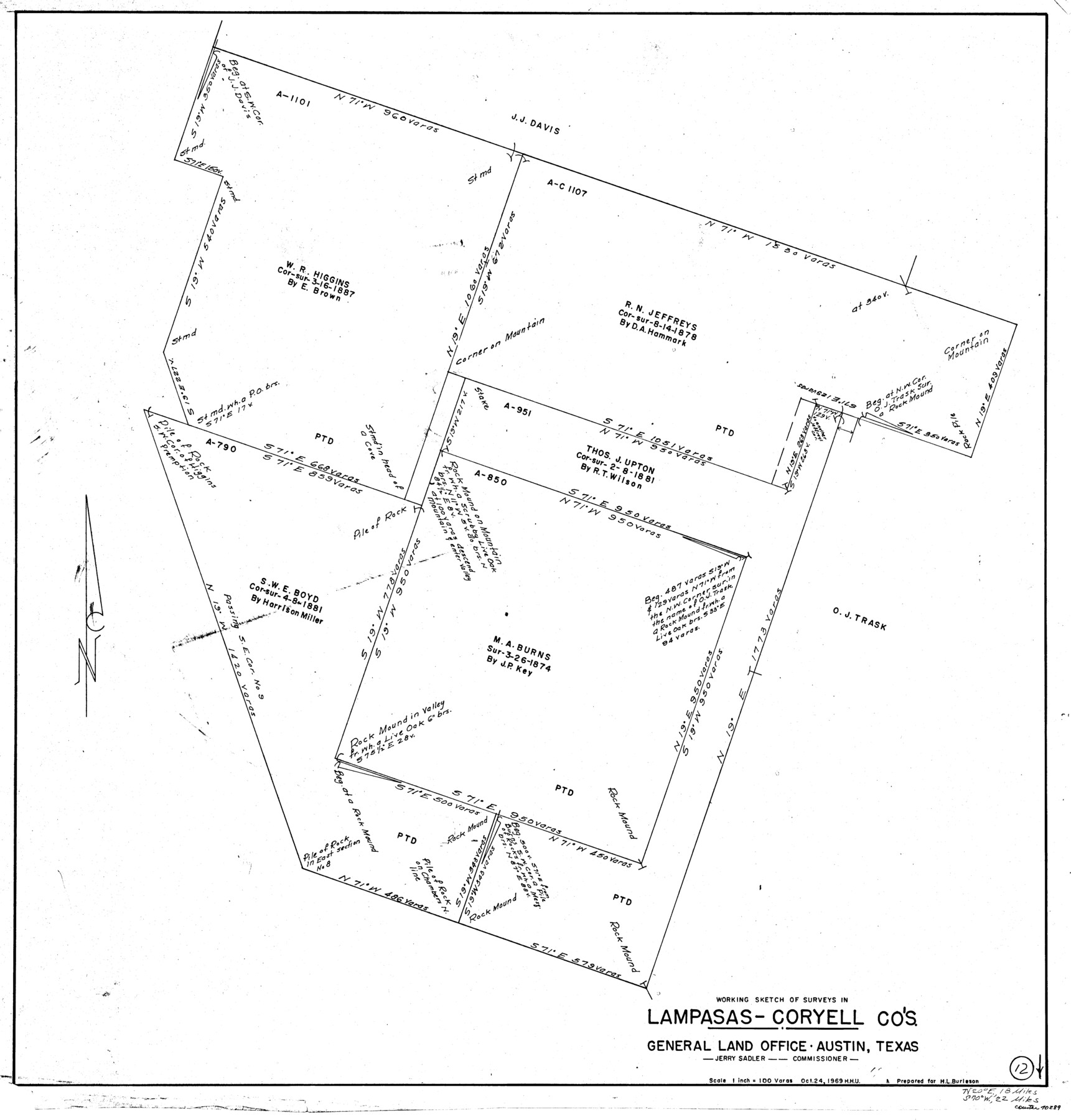
Lampasas County Working Sketch 12
-
Map/Doc
70289
-
Collection
General Map Collection
-
Object Dates
10/24/1969 (Creation Date)
-
People and Organizations
Herbert H. Ulbricht (Draftsman)
-
Counties
Lampasas Coryell
-
Subjects
Surveying Working Sketch
-
Height x Width
32.9 x 31.4 inches
83.6 x 79.8 cm
-
Scale
1" = 100 varas
Part of: General Map Collection
Presidio County Working Sketch 137

Print $20.00
- Digital $50.00
Presidio County Working Sketch 137
1990
Size 24.1 x 42.8 inches
Map/Doc 71815
Armstrong County Sketch File A-13

Print $40.00
- Digital $50.00
Armstrong County Sketch File A-13
Size 12.8 x 17.7 inches
Map/Doc 13714
La Salle County Sketch File 43

Print $20.00
- Digital $50.00
La Salle County Sketch File 43
1937
Size 18.7 x 28.4 inches
Map/Doc 11988
Flight Mission No. CRK-7P, Frame 133, Refugio County

Print $20.00
- Digital $50.00
Flight Mission No. CRK-7P, Frame 133, Refugio County
1956
Size 18.3 x 22.1 inches
Map/Doc 86956
Gray County Rolled Sketch 3

Print $105.00
- Digital $50.00
Gray County Rolled Sketch 3
Size 10.6 x 15.5 inches
Map/Doc 45287
Morris County Rolled Sketch 2A

Print $20.00
- Digital $50.00
Morris County Rolled Sketch 2A
Size 36.5 x 20.0 inches
Map/Doc 10269
Scurry County Working Sketch 9

Print $20.00
- Digital $50.00
Scurry County Working Sketch 9
1982
Size 37.8 x 43.5 inches
Map/Doc 63838
Anderson County Sketch File 15a

Print $4.00
- Digital $50.00
Anderson County Sketch File 15a
1859
Size 14.5 x 8.0 inches
Map/Doc 12781
Flight Mission No. BRA-9M, Frame 60, Jefferson County

Print $20.00
- Digital $50.00
Flight Mission No. BRA-9M, Frame 60, Jefferson County
1953
Size 18.6 x 22.4 inches
Map/Doc 85643
Map of the Location Survey of the Hearne & Brazos Valley Railroad

Print $40.00
- Digital $50.00
Map of the Location Survey of the Hearne & Brazos Valley Railroad
1891
Size 40.7 x 122.9 inches
Map/Doc 64347
Lynn County Rolled Sketch 14

Print $20.00
- Digital $50.00
Lynn County Rolled Sketch 14
1952
Size 35.4 x 35.3 inches
Map/Doc 9474
Terry County Boundary File 2

Print $10.00
- Digital $50.00
Terry County Boundary File 2
Size 9.1 x 8.8 inches
Map/Doc 59204
You may also like
Township No. 5 South, Range No. 14 West, Indian Meridian, Oklahoma

Print $4.00
- Digital $50.00
Township No. 5 South, Range No. 14 West, Indian Meridian, Oklahoma
1928
Size 18.0 x 22.6 inches
Map/Doc 75141
Hardeman County Working Sketch 2

Print $20.00
- Digital $50.00
Hardeman County Working Sketch 2
1900
Size 19.1 x 19.4 inches
Map/Doc 63383
W. C. Baze Subdivision a part of Tracts 25, 26, 27 and 28, Ross Addition to City of Idalou, Lubbock Co.

Print $20.00
- Digital $50.00
W. C. Baze Subdivision a part of Tracts 25, 26, 27 and 28, Ross Addition to City of Idalou, Lubbock Co.
1955
Size 9.2 x 18.9 inches
Map/Doc 92761
Brooks County Rolled Sketch 28

Print $20.00
- Digital $50.00
Brooks County Rolled Sketch 28
1947
Size 28.9 x 32.0 inches
Map/Doc 5346
Medina County Sketch File 19

Print $20.00
- Digital $50.00
Medina County Sketch File 19
1989
Size 32.5 x 21.0 inches
Map/Doc 12071
Official Map City of Lubbock Lubbock County, Texas

Print $20.00
- Digital $50.00
Official Map City of Lubbock Lubbock County, Texas
1927
Size 44.6 x 33.4 inches
Map/Doc 93220
Myrick Farm Lubbock & Hockley Counties

Print $20.00
- Digital $50.00
Myrick Farm Lubbock & Hockley Counties
Size 21.1 x 18.8 inches
Map/Doc 92831
Childress County Rolled Sketch 9

Print $20.00
- Digital $50.00
Childress County Rolled Sketch 9
Size 19.3 x 22.9 inches
Map/Doc 5446
[Northeast portion of Grayson County]
![78364, [Northeast portion of Grayson County], General Map Collection](https://historictexasmaps.com/wmedia_w700/maps/78364.tif.jpg)
Print $20.00
- Digital $50.00
[Northeast portion of Grayson County]
Size 12.0 x 14.0 inches
Map/Doc 78364
Webb County Rolled Sketch 65

Print $20.00
- Digital $50.00
Webb County Rolled Sketch 65
1949
Size 37.1 x 24.3 inches
Map/Doc 8214
Val Verde County Working Sketch 85

Print $20.00
- Digital $50.00
Val Verde County Working Sketch 85
1973
Size 28.5 x 38.3 inches
Map/Doc 72220
Cochran County

Print $20.00
- Digital $50.00
Cochran County
1946
Size 33.0 x 25.3 inches
Map/Doc 73107