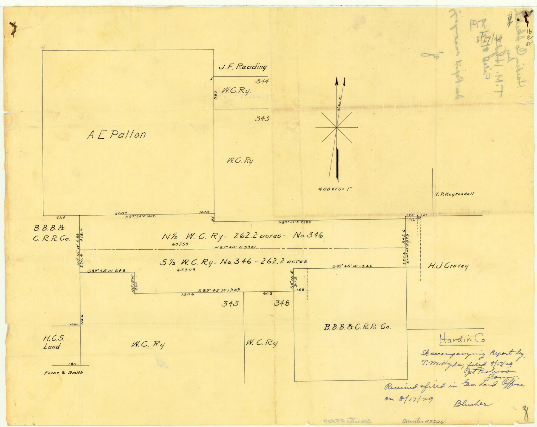
Hardin County Sketch File 56a
[Sketch showing W. C. RR. Co. survey 346 subdivision]
-
Map/Doc
25226
-
Collection
General Map Collection
-
Object Dates
1929/8/17 (File Date)
-
People and Organizations
T.M. Hyde (Surveyor/Engineer)
-
Counties
Hardin
-
Subjects
Surveying Sketch File
-
Height x Width
12.7 x 15.9 inches
32.3 x 40.4 cm
-
Medium
paper, manuscript
Part of: General Map Collection
Brazoria County Rolled Sketch 18

Print $20.00
- Digital $50.00
Brazoria County Rolled Sketch 18
Size 28.0 x 22.5 inches
Map/Doc 5163
Childress County Sketch File 24

Print $4.00
- Digital $50.00
Childress County Sketch File 24
1917
Size 12.9 x 8.6 inches
Map/Doc 18384
Walker County Working Sketch 7

Print $20.00
- Digital $50.00
Walker County Working Sketch 7
1935
Size 38.3 x 43.2 inches
Map/Doc 72287
Mills County Working Sketch 2

Print $20.00
- Digital $50.00
Mills County Working Sketch 2
1904
Size 12.7 x 15.8 inches
Map/Doc 71032
Uvalde County Sketch File 26-1

Print $6.00
- Digital $50.00
Uvalde County Sketch File 26-1
1930
Size 11.5 x 8.9 inches
Map/Doc 39013
Liberty County Sketch File 27

Print $5.00
- Digital $50.00
Liberty County Sketch File 27
Size 11.5 x 9.3 inches
Map/Doc 29948
[Surveys along Verde and Bandera Creeks]
![289, [Surveys along Verde and Bandera Creeks], General Map Collection](https://historictexasmaps.com/wmedia_w700/maps/289.tif.jpg)
Print $2.00
- Digital $50.00
[Surveys along Verde and Bandera Creeks]
1846
Size 10.0 x 8.0 inches
Map/Doc 289
Jeff Davis County Working Sketch 37

Print $20.00
- Digital $50.00
Jeff Davis County Working Sketch 37
1979
Size 31.6 x 36.6 inches
Map/Doc 66532
Reagan County Sketch File 19

Print $26.00
- Digital $50.00
Reagan County Sketch File 19
1937
Size 14.0 x 28.7 inches
Map/Doc 12220
Flight Mission No. BRA-16M, Frame 67, Jefferson County

Print $20.00
- Digital $50.00
Flight Mission No. BRA-16M, Frame 67, Jefferson County
1953
Size 18.6 x 22.4 inches
Map/Doc 85684
Briscoe County Sketch File 14

Print $20.00
- Digital $50.00
Briscoe County Sketch File 14
1910
Size 14.2 x 8.5 inches
Map/Doc 16509
Guadalupe County Sketch File 3a

Print $4.00
- Digital $50.00
Guadalupe County Sketch File 3a
1849
Size 10.7 x 8.2 inches
Map/Doc 24652
You may also like
Liberty County Sketch File M

Print $20.00
- Digital $50.00
Liberty County Sketch File M
1879
Size 16.9 x 14.5 inches
Map/Doc 12000
Official Map of the Highway System of Texas

Print $20.00
- Digital $50.00
Official Map of the Highway System of Texas
1936
Size 27.5 x 33.4 inches
Map/Doc 83598
Eastland County Boundary File 1

Print $10.00
- Digital $50.00
Eastland County Boundary File 1
Size 11.1 x 8.5 inches
Map/Doc 52780
Gregg County Boundary File 8

Print $8.00
- Digital $50.00
Gregg County Boundary File 8
Size 14.0 x 8.6 inches
Map/Doc 54019
Flight Mission No. CLL-4N, Frame 37, Willacy County

Print $20.00
- Digital $50.00
Flight Mission No. CLL-4N, Frame 37, Willacy County
1954
Size 18.4 x 22.1 inches
Map/Doc 87110
Andrews County Rolled Sketch 46

Print $40.00
- Digital $50.00
Andrews County Rolled Sketch 46
2013
Size 52.0 x 36.0 inches
Map/Doc 93641
Scrivener's North-west Sub-division, Wichita County, Texas

Print $20.00
- Digital $50.00
Scrivener's North-west Sub-division, Wichita County, Texas
Size 20.0 x 26.0 inches
Map/Doc 91994
[Neches River Bed, Plat and Calculations]
![2466, [Neches River Bed, Plat and Calculations], General Map Collection](https://historictexasmaps.com/wmedia_w700/maps/2466-GC.tif.jpg)
Print $40.00
- Digital $50.00
[Neches River Bed, Plat and Calculations]
1928
Size 27.3 x 51.0 inches
Map/Doc 2466
Wise County Working Sketch 13

Print $20.00
- Digital $50.00
Wise County Working Sketch 13
1971
Size 27.9 x 34.0 inches
Map/Doc 72627
Wharton County Working Sketch 18

Print $20.00
- Digital $50.00
Wharton County Working Sketch 18
1948
Size 19.3 x 17.0 inches
Map/Doc 72482
Sutton County Working Sketch 23

Print $20.00
- Digital $50.00
Sutton County Working Sketch 23
1981
Size 17.3 x 27.1 inches
Map/Doc 62366
Flight Mission No. BRE-1P, Frame 58, Nueces County

Print $20.00
- Digital $50.00
Flight Mission No. BRE-1P, Frame 58, Nueces County
1956
Size 18.5 x 22.2 inches
Map/Doc 86647