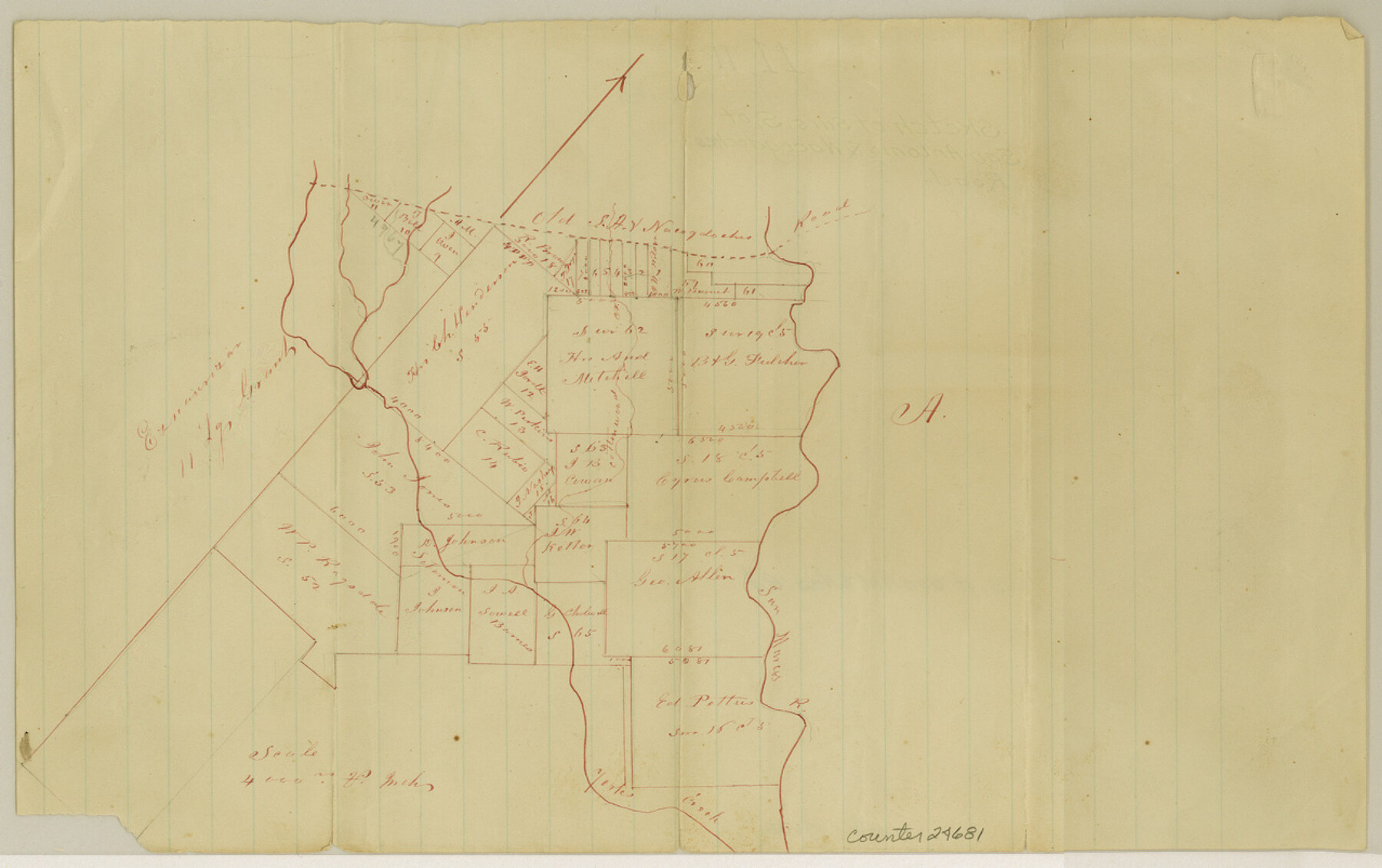
Guadalupe County Sketch File 11
[Sketch of surveys south of San Antonio and Nacogdoches Road]
-
Map/Doc
24681
-
Collection
General Map Collection
-
Counties
Guadalupe Hays
-
Subjects
Surveying Sketch File
-
Height x Width
8.0 x 12.8 inches
20.3 x 32.5 cm
-
Medium
paper, manuscript
-
Scale
1:4000
-
Features
Old San Antonio & Nacogdoches Road
San Marcos River
Part of: General Map Collection
Flight Mission No. DIX-7P, Frame 23, Aransas County

Print $20.00
- Digital $50.00
Flight Mission No. DIX-7P, Frame 23, Aransas County
1956
Size 18.7 x 22.4 inches
Map/Doc 83875
Jefferson County Rolled Sketch 12

Print $2.00
- Digital $50.00
Jefferson County Rolled Sketch 12
Size 10.6 x 8.2 inches
Map/Doc 76004
Matagorda County NRC Article 33.136 Sketch 9

Print $28.00
- Digital $50.00
Matagorda County NRC Article 33.136 Sketch 9
2011
Size 24.0 x 36.0 inches
Map/Doc 94811
Cherokee County Sketch File 5

Print $12.00
- Digital $50.00
Cherokee County Sketch File 5
1852
Size 12.4 x 8.6 inches
Map/Doc 18120
Victoria County Rolled Sketch 8

Print $20.00
- Digital $50.00
Victoria County Rolled Sketch 8
Size 34.2 x 27.5 inches
Map/Doc 8153
Gaines County Working Sketch 33

Print $40.00
- Digital $50.00
Gaines County Working Sketch 33
1990
Size 50.3 x 36.0 inches
Map/Doc 69333
Zapata County Rolled Sketch 14

Print $20.00
- Digital $50.00
Zapata County Rolled Sketch 14
1925
Size 19.2 x 43.7 inches
Map/Doc 10168
Val Verde County Rolled Sketch 62

Print $40.00
- Digital $50.00
Val Verde County Rolled Sketch 62
1956
Size 34.6 x 52.1 inches
Map/Doc 10081
Wise County Sketch File 12

Print $20.00
- Digital $50.00
Wise County Sketch File 12
1854
Size 13.4 x 19.0 inches
Map/Doc 12699
[Maps of surveys in Reeves & Culberson Cos]
![61137, [Maps of surveys in Reeves & Culberson Cos], General Map Collection](https://historictexasmaps.com/wmedia_w700/maps/61137.tif.jpg)
Print $20.00
- Digital $50.00
[Maps of surveys in Reeves & Culberson Cos]
1937
Size 30.5 x 24.8 inches
Map/Doc 61137
Marion County Rolled Sketch 5

Print $20.00
- Digital $50.00
Marion County Rolled Sketch 5
1961
Size 22.6 x 20.5 inches
Map/Doc 6658
Map of Hunt County

Print $20.00
- Digital $50.00
Map of Hunt County
1851
Size 25.1 x 18.7 inches
Map/Doc 3690
You may also like
[Sketch of common corner of Oldham, Potter, Deaf Smith and Randall Counties]
![93060, [Sketch of common corner of Oldham, Potter, Deaf Smith and Randall Counties], Twichell Survey Records](https://historictexasmaps.com/wmedia_w700/maps/93060-1.tif.jpg)
Print $20.00
- Digital $50.00
[Sketch of common corner of Oldham, Potter, Deaf Smith and Randall Counties]
Size 17.2 x 33.1 inches
Map/Doc 93060
[Large surveys along the Navasota River]
![48, [Large surveys along the Navasota River], General Map Collection](https://historictexasmaps.com/wmedia_w700/maps/48.tif.jpg)
Print $20.00
- Digital $50.00
[Large surveys along the Navasota River]
1840
Size 24.5 x 14.3 inches
Map/Doc 48
Armstrong County Boundary File 5

Print $8.00
- Digital $50.00
Armstrong County Boundary File 5
Size 11.2 x 8.9 inches
Map/Doc 50149
Outer Continental Shelf Leasing Maps (Texas Offshore Operations)

Print $20.00
- Digital $50.00
Outer Continental Shelf Leasing Maps (Texas Offshore Operations)
Size 17.6 x 13.8 inches
Map/Doc 75844
Flight Mission No. CGI-3N, Frame 120, Cameron County

Print $20.00
- Digital $50.00
Flight Mission No. CGI-3N, Frame 120, Cameron County
1954
Size 18.8 x 22.3 inches
Map/Doc 84593
Farmer Subdivision of Wm. Baker Survey

Print $20.00
- Digital $50.00
Farmer Subdivision of Wm. Baker Survey
Size 16.1 x 15.5 inches
Map/Doc 90122
Working Sketch in Dickens and Kent Counties

Print $20.00
- Digital $50.00
Working Sketch in Dickens and Kent Counties
1904
Size 24.2 x 30.5 inches
Map/Doc 91035
State Prison System, Cherokee County

Print $20.00
- Digital $50.00
State Prison System, Cherokee County
Size 15.7 x 33.1 inches
Map/Doc 73560
Archer County Working Sketch 7

Print $20.00
- Digital $50.00
Archer County Working Sketch 7
1921
Size 32.6 x 24.9 inches
Map/Doc 67147
Upton County Sketch File 10

Print $18.00
- Digital $50.00
Upton County Sketch File 10
1919
Size 13.5 x 8.7 inches
Map/Doc 38839
Hardin County Working Sketch 44

Print $40.00
- Digital $50.00
Hardin County Working Sketch 44
1954
Size 53.2 x 39.9 inches
Map/Doc 65610
Colorado County Sketch File 27

Print $20.00
- Digital $50.00
Colorado County Sketch File 27
1911
Size 25.3 x 19.4 inches
Map/Doc 11138