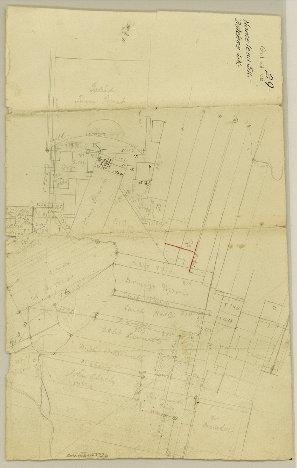
Goliad County Sketch File 29
[Sketch of Goliad Town Tract and surveys to the south]
-
Map/Doc
24326
-
Collection
General Map Collection
-
Counties
Goliad
-
Subjects
Surveying Sketch File
-
Height x Width
12.6 x 8.0 inches
32.0 x 20.3 cm
-
Medium
paper, manuscript
-
Features
Goliad
Part of: General Map Collection
Denton County Working Sketch 10

Print $20.00
- Digital $50.00
Denton County Working Sketch 10
1960
Size 30.2 x 25.0 inches
Map/Doc 68615
Concho County Sketch File 29

Print $12.00
- Digital $50.00
Concho County Sketch File 29
1886
Size 11.7 x 9.0 inches
Map/Doc 19169
Newton County Rolled Sketch 7

Print $20.00
- Digital $50.00
Newton County Rolled Sketch 7
1943
Size 21.4 x 37.2 inches
Map/Doc 6843
Cameron County Sketch File 12

Print $222.00
- Digital $50.00
Cameron County Sketch File 12
Size 10.8 x 7.4 inches
Map/Doc 17236
Jack County Working Sketch 19

Print $20.00
- Digital $50.00
Jack County Working Sketch 19
1989
Size 21.5 x 29.4 inches
Map/Doc 66445
G. C. & S. F., Main Line, Texas, Right of Way map, Rio Vista to Crowley

Print $40.00
- Digital $50.00
G. C. & S. F., Main Line, Texas, Right of Way map, Rio Vista to Crowley
1910
Size 38.1 x 122.4 inches
Map/Doc 64653
Dimmit County Sketch File 11b

Print $20.00
- Digital $50.00
Dimmit County Sketch File 11b
1909
Size 30.3 x 26.7 inches
Map/Doc 11340
Limestone County Working Sketch 3

Print $20.00
- Digital $50.00
Limestone County Working Sketch 3
1919
Size 28.9 x 28.5 inches
Map/Doc 70553
Red River County Rolled Sketch 4

Print $20.00
- Digital $50.00
Red River County Rolled Sketch 4
Size 37.3 x 32.2 inches
Map/Doc 9841
Colonists' and Emigrants' Route to Texas

Print $20.00
- Digital $50.00
Colonists' and Emigrants' Route to Texas
1878
Size 14.8 x 24.0 inches
Map/Doc 94033
Knox County Rolled Sketch 9

Print $20.00
- Digital $50.00
Knox County Rolled Sketch 9
Size 26.1 x 33.0 inches
Map/Doc 9407
Chambers County Sketch File 12

Print $6.00
- Digital $50.00
Chambers County Sketch File 12
1873
Size 16.5 x 11.3 inches
Map/Doc 17556
You may also like
[Blocks D3 and GP]
![91504, [Blocks D3 and GP], Twichell Survey Records](https://historictexasmaps.com/wmedia_w700/maps/91504-1.tif.jpg)
Print $20.00
- Digital $50.00
[Blocks D3 and GP]
Size 18.5 x 19.9 inches
Map/Doc 91504
Gregg County Working Sketch 19

Print $20.00
- Digital $50.00
Gregg County Working Sketch 19
1957
Size 31.7 x 37.3 inches
Map/Doc 63286
Hays County Sketch File 17

Print $8.00
- Digital $50.00
Hays County Sketch File 17
1877
Size 12.9 x 8.4 inches
Map/Doc 26231
Flight Mission No. DQN-1K, Frame 72, Calhoun County

Print $20.00
- Digital $50.00
Flight Mission No. DQN-1K, Frame 72, Calhoun County
1953
Size 18.4 x 22.3 inches
Map/Doc 84159
Travis County

Print $40.00
- Digital $50.00
Travis County
1936
Size 47.0 x 53.7 inches
Map/Doc 73305
W. M. Kuykendall Ranch, Matagorda County, Texas

Print $20.00
- Digital $50.00
W. M. Kuykendall Ranch, Matagorda County, Texas
1926
Size 24.3 x 39.6 inches
Map/Doc 3028
Medina County Rolled Sketch 7

Print $20.00
- Digital $50.00
Medina County Rolled Sketch 7
1966
Size 36.9 x 21.9 inches
Map/Doc 6741
Cass County Working Sketch Graphic Index

Print $20.00
- Digital $50.00
Cass County Working Sketch Graphic Index
1947
Size 39.1 x 41.9 inches
Map/Doc 76489
Bowie County Working Sketch 16

Print $20.00
- Digital $50.00
Bowie County Working Sketch 16
1961
Size 17.8 x 17.2 inches
Map/Doc 67420
Live Oak County Working Sketch 30

Print $20.00
- Digital $50.00
Live Oak County Working Sketch 30
1988
Size 19.0 x 25.9 inches
Map/Doc 70615
Reference Book of Burnet's, [Vehlein's] & Zavala's Colonies
![94554, Reference Book of Burnet's, [Vehlein's] & Zavala's Colonies, Historical Volumes](https://historictexasmaps.com/wmedia_w700/pdf_converted_jpg/qi_pdf_thumbnail_39143.jpg)
Reference Book of Burnet's, [Vehlein's] & Zavala's Colonies
Map/Doc 94554
San Patricio County NRC Article 33.136 Sketch 9

Print $82.00
San Patricio County NRC Article 33.136 Sketch 9
2022
Map/Doc 97031