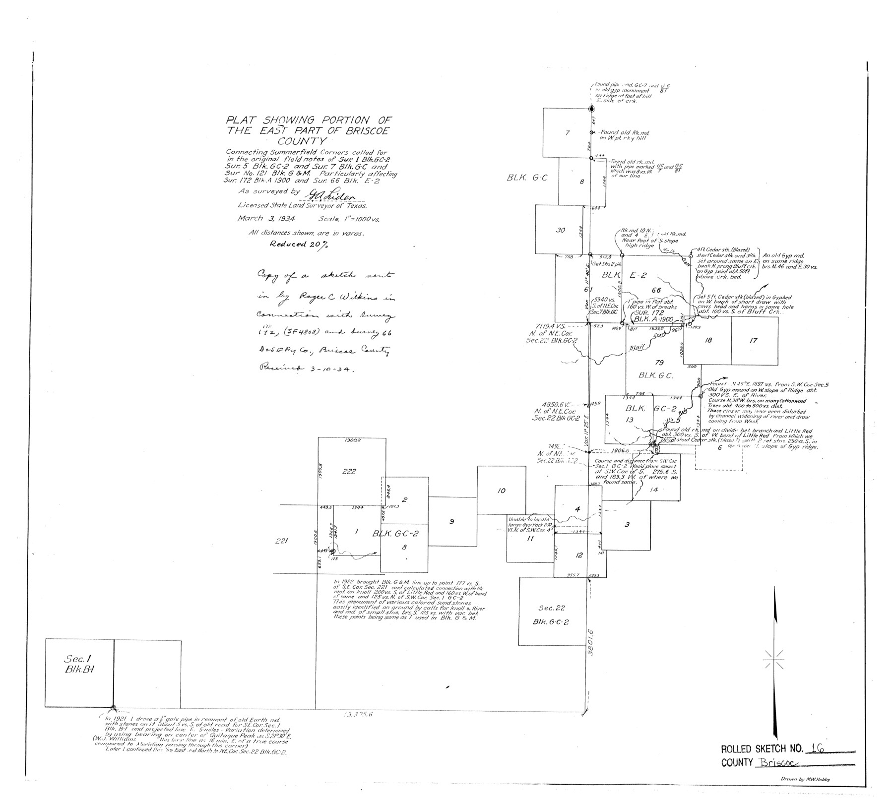
Briscoe County Rolled Sketch 16
Plat showing portion of the east part of Briscoe County connecting Summerfield corners called for in the original field notes of Sur. 1 Blk. GC-2, Sur. 5 Blk GC-2 and Sur. 7 Blk GC and Sur. No. 121 Blk. G. & M.
-
Map/Doc
5330
-
Collection
General Map Collection
-
Object Dates
1934/3/3 (Creation Date)
1934/3/10 (File Date)
-
People and Organizations
G.A. Lider (Surveyor/Engineer)
M.W. Hobbs (Draftsman)
-
Counties
Briscoe
-
Subjects
Surveying Rolled Sketch
-
Height x Width
17.8 x 19.9 inches
45.2 x 50.5 cm
-
Scale
1" = 1000 varas
Part of: General Map Collection
Gregg County Boundary File 6

Print $6.00
- Digital $50.00
Gregg County Boundary File 6
Size 8.5 x 5.8 inches
Map/Doc 54001
Martin County Working Sketch 6

Print $20.00
- Digital $50.00
Martin County Working Sketch 6
1971
Size 41.8 x 36.9 inches
Map/Doc 70824
Shelby County Rolled Sketch 6

Print $20.00
- Digital $50.00
Shelby County Rolled Sketch 6
Size 26.7 x 20.9 inches
Map/Doc 7776

Presidio County Working Sketch 4

Print $20.00
- Digital $50.00
Presidio County Working Sketch 4
1915
Size 26.3 x 21.7 inches
Map/Doc 71678
Montgomery County Working Sketch 3

Print $20.00
- Digital $50.00
Montgomery County Working Sketch 3
1918
Size 16.5 x 14.1 inches
Map/Doc 71109
Flight Mission No. DIX-5P, Frame 147, Aransas County

Print $20.00
- Digital $50.00
Flight Mission No. DIX-5P, Frame 147, Aransas County
1956
Size 17.8 x 18.1 inches
Map/Doc 83809
Topographical Map of the Rio Grande, Sheet No. 13

Print $20.00
- Digital $50.00
Topographical Map of the Rio Grande, Sheet No. 13
1912
Map/Doc 89537
Map of Marion County

Print $20.00
- Digital $50.00
Map of Marion County
1920
Size 29.2 x 43.2 inches
Map/Doc 66916
Presidio County Rolled Sketch 53

Print $20.00
- Digital $50.00
Presidio County Rolled Sketch 53
1911
Size 23.9 x 18.2 inches
Map/Doc 7347
Armstrong County Sketch File A-9

Print $40.00
- Digital $50.00
Armstrong County Sketch File A-9
1920
Size 13.7 x 35.4 inches
Map/Doc 10851
Bee County Working Sketch 19

Print $20.00
- Digital $50.00
Bee County Working Sketch 19
1980
Size 17.3 x 11.9 inches
Map/Doc 67269
You may also like
Rio Grande Rectification Project, El Paso and Juarez Valley

Print $20.00
- Digital $50.00
Rio Grande Rectification Project, El Paso and Juarez Valley
1935
Size 10.9 x 29.6 inches
Map/Doc 60868
Callahan County Rolled Sketch 1

Print $20.00
- Digital $50.00
Callahan County Rolled Sketch 1
1944
Size 26.9 x 26.3 inches
Map/Doc 5379
Laguna Madre, T-9210

Print $20.00
- Digital $50.00
Laguna Madre, T-9210
Size 34.6 x 31.9 inches
Map/Doc 73601
Crane County Working Sketch 30

Print $20.00
- Digital $50.00
Crane County Working Sketch 30
1980
Size 37.5 x 39.2 inches
Map/Doc 68307
[Sketch Showing Wm. T. Brewer, John R. Taylor, Wm. F. Butler, Timothy DeVore, L. M. Thorn and adjoining surveys]
![90121, [Sketch Showing Wm. T. Brewer, John R. Taylor, Wm. F. Butler, Timothy DeVore, L. M. Thorn and adjoining surveys], Twichell Survey Records](https://historictexasmaps.com/wmedia_w700/maps/90121-1.tif.jpg)
Print $20.00
- Digital $50.00
[Sketch Showing Wm. T. Brewer, John R. Taylor, Wm. F. Butler, Timothy DeVore, L. M. Thorn and adjoining surveys]
Size 27.2 x 19.3 inches
Map/Doc 90121
Hutchinson County Rolled Sketch 44-5

Print $20.00
- Digital $50.00
Hutchinson County Rolled Sketch 44-5
2002
Size 24.0 x 36.0 inches
Map/Doc 77541
Map of section no. 8 of a survey of Padre Island made for the Office of the Attorney General of the State of Texas

Print $40.00
- Digital $50.00
Map of section no. 8 of a survey of Padre Island made for the Office of the Attorney General of the State of Texas
1941
Size 56.2 x 40.3 inches
Map/Doc 2264
El Paso County Working Sketch 7

Print $20.00
- Digital $50.00
El Paso County Working Sketch 7
1928
Size 25.7 x 16.9 inches
Map/Doc 69029
Travis County Working Sketch 2

Print $20.00
- Digital $50.00
Travis County Working Sketch 2
1906
Size 30.8 x 25.9 inches
Map/Doc 69386
Topographic Map of Big Bend Area

Print $20.00
Topographic Map of Big Bend Area
1923
Size 35.5 x 40.7 inches
Map/Doc 79758
Corpus Christi Pass, Texas

Print $20.00
- Digital $50.00
Corpus Christi Pass, Texas
1871
Size 26.2 x 18.3 inches
Map/Doc 72979
Martin County Rolled Sketch 6

Print $20.00
- Digital $50.00
Martin County Rolled Sketch 6
Size 25.8 x 26.9 inches
Map/Doc 6666