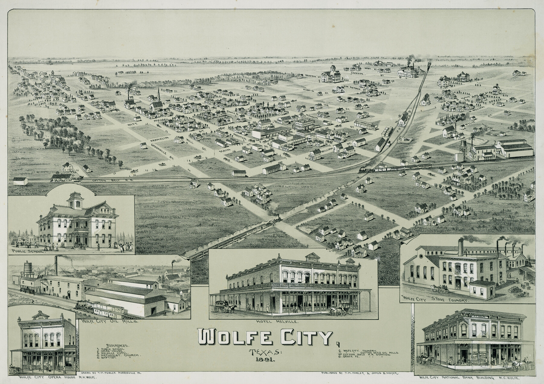
Wolfe City, Texas
-
Map/Doc
89215
-
Collection
Non-GLO Digital Images
-
Object Dates
1891 (Creation Date)
-
People and Organizations
T. M. Fowler, James B. Moyer (Publisher)
Thaddeus Mortimer Fowler (Draftsman)
-
Counties
Hunt
-
Subjects
Bird's Eye View City Pictorial
-
Height x Width
14.5 x 20.5 inches
36.8 x 52.1 cm
-
Comments
Bird's Eye View map. Public Domain image obtained from Wikimedia Commons.
Part of: Non-GLO Digital Images
Bird's Eye View of Victoria

Print $20.00
Bird's Eye View of Victoria
1873
Size 24.6 x 28.9 inches
Map/Doc 89210
Map of the City of Austin

Print $20.00
Map of the City of Austin
1910
Size 24.0 x 18.0 inches
Map/Doc 90071
Mapa del Presidio de San Antonio de Bexar, i sus Misiones de la Provinsia de Texas

Print $20.00
Mapa del Presidio de San Antonio de Bexar, i sus Misiones de la Provinsia de Texas
1764
Size 14.5 x 18.4 inches
Map/Doc 94455
[Movements & Objectives of the 143rd & 144th Infantry and many other divisions and regiments, 1918]
![94138, [Movements & Objectives of the 143rd & 144th Infantry and many other divisions and regiments, 1918], Non-GLO Digital Images](https://historictexasmaps.com/wmedia_w700/maps/94138-1.tif.jpg)
Print $40.00
[Movements & Objectives of the 143rd & 144th Infantry and many other divisions and regiments, 1918]
1918
Size 64.2 x 37.5 inches
Map/Doc 94138
Mexico, California and Texas

Print $20.00
Mexico, California and Texas
1850
Size 11.1 x 15.0 inches
Map/Doc 82964
Map of the Interior of Louisiana with a part of New Mexico

Print $20.00
Map of the Interior of Louisiana with a part of New Mexico
1811
Size 11.1 x 14.2 inches
Map/Doc 94269
Bird's Eye View of the City of Austin, Travis County, Texas

Print $20.00
Bird's Eye View of the City of Austin, Travis County, Texas
1873
Size 21.3 x 28.7 inches
Map/Doc 89217
Map of Texas and the Countries Adjacent

Map of Texas and the Countries Adjacent
1844
Size 19.0 x 29.6 inches
Map/Doc 94561
A Geological Map of the United States and Canada

Print $20.00
A Geological Map of the United States and Canada
1853
Size 17.4 x 25.0 inches
Map/Doc 95189
Plan of New Orleans

Print $20.00
- Digital $50.00
Plan of New Orleans
1860
Size 12.8 x 15.7 inches
Map/Doc 95910
Houston, Texas (Looking South)

Print $20.00
Houston, Texas (Looking South)
1891
Size 25.3 x 41.1 inches
Map/Doc 89094
Carte de la Louisiane et du Cours du Mississipi

Print $20.00
Carte de la Louisiane et du Cours du Mississipi
1718
Size 16.6 x 21.8 inches
Map/Doc 89216
You may also like
[Channing Vacancy, Leagues 217- 235 and Vicinity]
![91483, [Channing Vacancy, Leagues 217- 235 and Vicinity], Twichell Survey Records](https://historictexasmaps.com/wmedia_w700/maps/91483-1.tif.jpg)
Print $20.00
- Digital $50.00
[Channing Vacancy, Leagues 217- 235 and Vicinity]
Size 26.7 x 27.6 inches
Map/Doc 91483
Brown County Sketch File 25

Print $6.00
- Digital $50.00
Brown County Sketch File 25
1890
Size 11.2 x 15.4 inches
Map/Doc 16623
Presidio County Sketch File F

Print $2.00
- Digital $50.00
Presidio County Sketch File F
Size 15.5 x 8.2 inches
Map/Doc 34428
Val Verde County Rolled Sketch 3X

Print $20.00
- Digital $50.00
Val Verde County Rolled Sketch 3X
Size 27.9 x 30.9 inches
Map/Doc 8107
The Official Map of the City of El Paso, State of Texas

Print $40.00
The Official Map of the City of El Paso, State of Texas
1889
Size 83.6 x 97.2 inches
Map/Doc 89619
[Connecting lines from west corner of S. K. & K. Block M6 to northwest corner section 1, J. G. & S. M. Blk. 2Z]
![90399, [Connecting lines from west corner of S. K. & K. Block M6 to northwest corner section 1, J. G. & S. M. Blk. 2Z], Twichell Survey Records](https://historictexasmaps.com/wmedia_w700/maps/90399-1.tif.jpg)
Print $20.00
- Digital $50.00
[Connecting lines from west corner of S. K. & K. Block M6 to northwest corner section 1, J. G. & S. M. Blk. 2Z]
Size 25.1 x 17.0 inches
Map/Doc 90399
Flight Mission No. DQO-8K, Frame 90, Galveston County

Print $20.00
- Digital $50.00
Flight Mission No. DQO-8K, Frame 90, Galveston County
1952
Size 17.9 x 22.3 inches
Map/Doc 85192
Atascosa County Rolled Sketch 21

Print $20.00
- Digital $50.00
Atascosa County Rolled Sketch 21
1958
Size 25.0 x 38.0 inches
Map/Doc 5100
Vicinity of San Luis Pass, Galveston Island, Texas

Print $40.00
- Digital $50.00
Vicinity of San Luis Pass, Galveston Island, Texas
1933
Size 37.1 x 57.8 inches
Map/Doc 69943
Colonists' and Emigrants' Route to Texas

Print $20.00
- Digital $50.00
Colonists' and Emigrants' Route to Texas
1878
Size 14.8 x 23.7 inches
Map/Doc 95777
Matagorda County Working Sketch 18

Print $20.00
- Digital $50.00
Matagorda County Working Sketch 18
1961
Size 31.2 x 41.8 inches
Map/Doc 70876
San Jacinto River, Water Sheds of the San Jacinto River and Buffalo Bayou

Print $4.00
- Digital $50.00
San Jacinto River, Water Sheds of the San Jacinto River and Buffalo Bayou
Size 28.8 x 20.0 inches
Map/Doc 65149