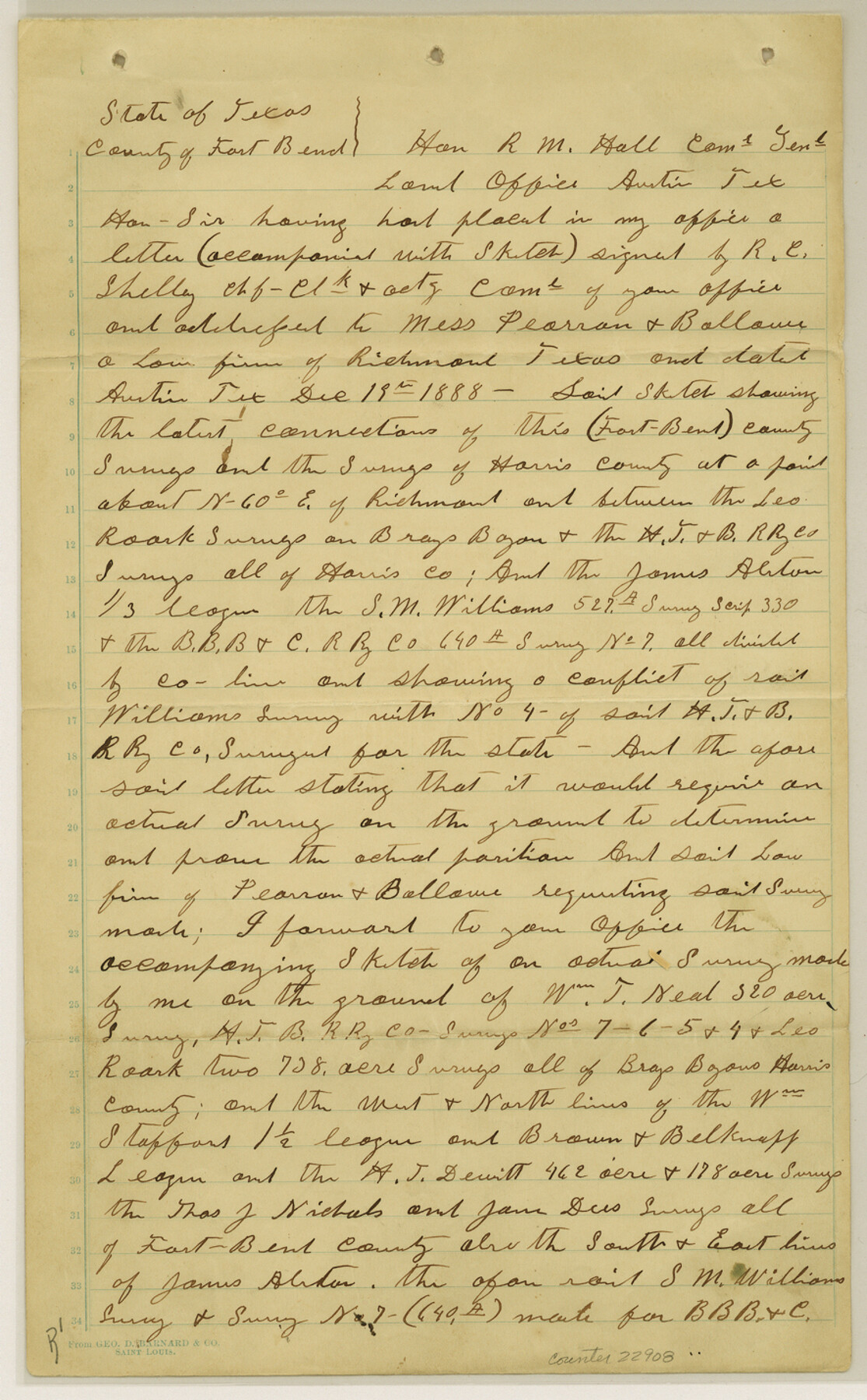
Fort Bend County Sketch File 13
[Report and sketch showing the connections of Harris County surveys with those of Fort Bend surveys in the eastern part of the county]
-
Map/Doc
22908
-
Collection
General Map Collection
-
Object Dates
1888 (Creation Date)
5/10/1889 (File Date)
-
People and Organizations
S.M. Farr (Surveyor/Engineer)
William Butts (Chainman)
S.M. Farr (Chainman)
T.J. Bendley (Chainman)
C.L. Reese (Chainman)
-
Counties
Fort Bend Harris
-
Subjects
Surveying Sketch File
-
Height x Width
14.3 x 8.8 inches
36.3 x 22.4 cm
-
Medium
paper, manuscript
-
Features
Richmond
Fort Bend Road
Brazos Bayou
North Fork of Brazos Bayou
South Fork of Brazos Bayou
Brays Bayou
Brazos River
Part of: General Map Collection
Presidio County Sketch File 105

Print $40.00
- Digital $50.00
Presidio County Sketch File 105
Size 15.6 x 59.1 inches
Map/Doc 82963
Floyd County Boundary File 1a

Print $40.00
- Digital $50.00
Floyd County Boundary File 1a
Size 9.2 x 37.4 inches
Map/Doc 53460
Edwards County Boundary File 27c

Print $29.00
- Digital $50.00
Edwards County Boundary File 27c
Size 12.8 x 8.1 inches
Map/Doc 52896
Flight Mission No. CRC-4R, Frame 100, Chambers County

Print $20.00
- Digital $50.00
Flight Mission No. CRC-4R, Frame 100, Chambers County
1956
Size 18.5 x 22.2 inches
Map/Doc 84897
Cameron County Rolled Sketch 19

Print $20.00
- Digital $50.00
Cameron County Rolled Sketch 19
1960
Size 27.0 x 20.5 inches
Map/Doc 5469
Bexar County Working Sketch 18

Print $20.00
- Digital $50.00
Bexar County Working Sketch 18
1979
Size 22.6 x 18.3 inches
Map/Doc 67334
Jeff Davis County Working Sketch 28

Print $20.00
- Digital $50.00
Jeff Davis County Working Sketch 28
1967
Size 21.2 x 28.6 inches
Map/Doc 66523
Flight Mission No. CUG-3P, Frame 95, Kleberg County

Print $20.00
- Digital $50.00
Flight Mission No. CUG-3P, Frame 95, Kleberg County
1956
Size 18.4 x 22.3 inches
Map/Doc 86265
Wichita County Boundary File 3

Print $40.00
- Digital $50.00
Wichita County Boundary File 3
Size 9.0 x 52.8 inches
Map/Doc 59913
Kinney County Rolled Sketch 18

Print $20.00
- Digital $50.00
Kinney County Rolled Sketch 18
1975
Size 22.4 x 28.6 inches
Map/Doc 6545
Flight Mission No. DIX-10P, Frame 64, Aransas County

Print $20.00
- Digital $50.00
Flight Mission No. DIX-10P, Frame 64, Aransas County
1956
Size 18.7 x 22.3 inches
Map/Doc 83925
Geological Map of the United States, Canada & c. compiled from the state surveys of the U.S. and other sources

Print $20.00
- Digital $50.00
Geological Map of the United States, Canada & c. compiled from the state surveys of the U.S. and other sources
Size 16.6 x 21.6 inches
Map/Doc 95173
You may also like
Shackelford County

Print $20.00
- Digital $50.00
Shackelford County
1920
Size 44.6 x 37.1 inches
Map/Doc 16813
The Republic County of Nacogdoches. January 1, 1838

Print $20.00
The Republic County of Nacogdoches. January 1, 1838
2020
Size 17.5 x 21.7 inches
Map/Doc 96244
Tyler County Sketch File 25

Print $28.00
- Digital $50.00
Tyler County Sketch File 25
1953
Size 14.5 x 9.0 inches
Map/Doc 38689
Zavala County Sketch File 9

Print $20.00
- Digital $50.00
Zavala County Sketch File 9
1884
Size 29.1 x 15.9 inches
Map/Doc 12727
Cochran County Boundary File 5

Print $12.00
- Digital $50.00
Cochran County Boundary File 5
Size 4.2 x 8.8 inches
Map/Doc 51556
Parmer County

Print $20.00
- Digital $50.00
Parmer County
1926
Size 43.9 x 35.4 inches
Map/Doc 73259
Sherman County, Texas

Print $20.00
- Digital $50.00
Sherman County, Texas
Size 19.1 x 18.8 inches
Map/Doc 753
Menard County Rolled Sketch 10

Print $20.00
- Digital $50.00
Menard County Rolled Sketch 10
1955
Size 46.7 x 37.7 inches
Map/Doc 9511
Travis County Sketch File 16

Print $4.00
- Digital $50.00
Travis County Sketch File 16
Size 12.7 x 8.4 inches
Map/Doc 38312
[Blocks 178, 194, Z]
![91579, [Blocks 178, 194, Z], Twichell Survey Records](https://historictexasmaps.com/wmedia_w700/maps/91579-1.tif.jpg)
Print $3.00
- Digital $50.00
[Blocks 178, 194, Z]
Size 12.8 x 10.5 inches
Map/Doc 91579
Cherokee County Sketch File 8

Print $4.00
- Digital $50.00
Cherokee County Sketch File 8
1854
Size 10.3 x 8.1 inches
Map/Doc 18130
Webb County Sketch File 66

Print $20.00
- Digital $50.00
Webb County Sketch File 66
1950
Size 13.4 x 20.6 inches
Map/Doc 12655