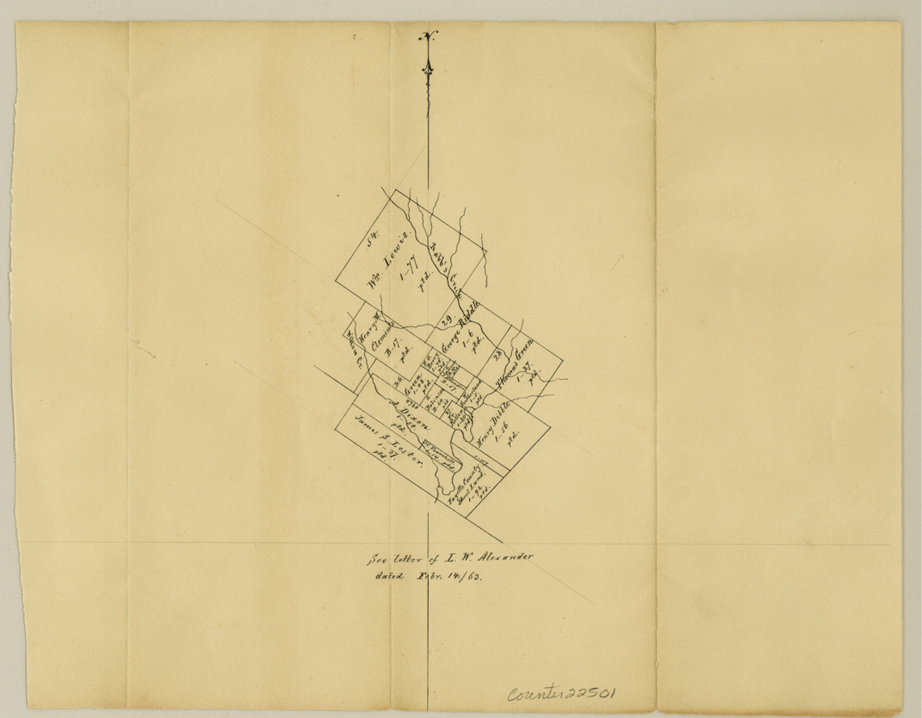
Fayette County Sketch File 3
[Sketch of surveys on Rabb's Creek, partly in Lee County]
-
Map/Doc
22501
-
Collection
General Map Collection
-
Object Dates
1863/2/24 (Creation Date)
-
Counties
Fayette Lee
-
Subjects
Surveying Sketch File
-
Height x Width
8.3 x 10.7 inches
21.1 x 27.2 cm
-
Medium
paper, manuscript
-
Features
Rabb's Creek
Willow Creek
Part of: General Map Collection
Liberty County Working Sketch 56

Print $40.00
- Digital $50.00
Liberty County Working Sketch 56
1966
Size 52.0 x 28.4 inches
Map/Doc 70516
Shelby County Working Sketch 14

Print $20.00
- Digital $50.00
Shelby County Working Sketch 14
1948
Size 28.5 x 22.3 inches
Map/Doc 63867

Brewster County Sketch File N-26

Print $40.00
- Digital $50.00
Brewster County Sketch File N-26
Size 20.5 x 15.4 inches
Map/Doc 10971
[Old Coastal Chart showing Brazo Chico, Brazo de Santiago and Rio Bravo del Norte passes with depth readings]
![4661, [Old Coastal Chart showing Brazo Chico, Brazo de Santiago and Rio Bravo del Norte passes with depth readings], General Map Collection](https://historictexasmaps.com/wmedia_w700/maps/4661-1.tif.jpg)
Print $20.00
- Digital $50.00
[Old Coastal Chart showing Brazo Chico, Brazo de Santiago and Rio Bravo del Norte passes with depth readings]
1837
Size 25.7 x 39.3 inches
Map/Doc 4661
Burnet County Rolled Sketch T

Print $20.00
- Digital $50.00
Burnet County Rolled Sketch T
Size 24.9 x 18.5 inches
Map/Doc 76053
Map of the upper surveys in Robertson's Colony Sold by the State of Coahuila and Texas

Print $20.00
- Digital $50.00
Map of the upper surveys in Robertson's Colony Sold by the State of Coahuila and Texas
Size 26.8 x 22.0 inches
Map/Doc 82
Baylor County Working Sketch Graphic Index

Print $20.00
- Digital $50.00
Baylor County Working Sketch Graphic Index
1961
Size 41.1 x 33.6 inches
Map/Doc 76463
Flight Mission No. DAG-17K, Frame 136, Matagorda County

Print $20.00
- Digital $50.00
Flight Mission No. DAG-17K, Frame 136, Matagorda County
1952
Size 18.5 x 22.3 inches
Map/Doc 86353
Flight Mission No. BQR-13K, Frame 28, Brazoria County

Print $20.00
- Digital $50.00
Flight Mission No. BQR-13K, Frame 28, Brazoria County
1952
Size 18.6 x 22.4 inches
Map/Doc 84076
Colorado County Sketch File 4

Print $40.00
- Digital $50.00
Colorado County Sketch File 4
1858
Size 12.8 x 15.7 inches
Map/Doc 18917
Duval County Sketch File 57

Print $14.00
- Digital $50.00
Duval County Sketch File 57
1939
Size 14.2 x 8.9 inches
Map/Doc 21418
You may also like
General Highway Map Moore County

Print $3.00
- Digital $50.00
General Highway Map Moore County
Size 14.4 x 10.3 inches
Map/Doc 92289
Ennis, Ellis County, Texas

Print $20.00
- Digital $50.00
Ennis, Ellis County, Texas
1934
Size 34.6 x 22.9 inches
Map/Doc 4826
Brewster County Rolled Sketch 150

Print $20.00
- Digital $50.00
Brewster County Rolled Sketch 150
Size 36.4 x 25.1 inches
Map/Doc 5317
Lampasas County Boundary File 3

Print $10.00
- Digital $50.00
Lampasas County Boundary File 3
Size 8.4 x 7.3 inches
Map/Doc 56101
Northwest Part Crockett County

Print $40.00
- Digital $50.00
Northwest Part Crockett County
1983
Size 37.3 x 48.3 inches
Map/Doc 95470
Map of the State of Texas [West Part]
![81921, Map of the State of Texas [West Part], General Map Collection](https://historictexasmaps.com/wmedia_w700/maps/81921.tif.jpg)
Print $40.00
- Digital $50.00
Map of the State of Texas [West Part]
1938
Size 68.7 x 38.2 inches
Map/Doc 81921
Map of Lampasas County

Print $20.00
- Digital $50.00
Map of Lampasas County
1864
Size 20.5 x 24.8 inches
Map/Doc 3793
Grayson County Sketch File 3a

Print $20.00
- Digital $50.00
Grayson County Sketch File 3a
1855
Size 19.6 x 25.5 inches
Map/Doc 11580
Presidio County Working Sketch 54

Print $20.00
- Digital $50.00
Presidio County Working Sketch 54
1955
Size 26.0 x 20.8 inches
Map/Doc 71731
Eastland County Working Sketch 61

Print $20.00
- Digital $50.00
Eastland County Working Sketch 61
1989
Size 35.4 x 41.0 inches
Map/Doc 68842
Ellis County Boundary File 3c

Print $130.00
- Digital $50.00
Ellis County Boundary File 3c
Size 10.9 x 8.7 inches
Map/Doc 52972
[Motley and Foard County School Land Leagues]
![90179, [Motley and Foard County School Land Leagues], Twichell Survey Records](https://historictexasmaps.com/wmedia_w700/maps/90179-1.tif.jpg)
Print $20.00
- Digital $50.00
[Motley and Foard County School Land Leagues]
Size 22.8 x 29.6 inches
Map/Doc 90179