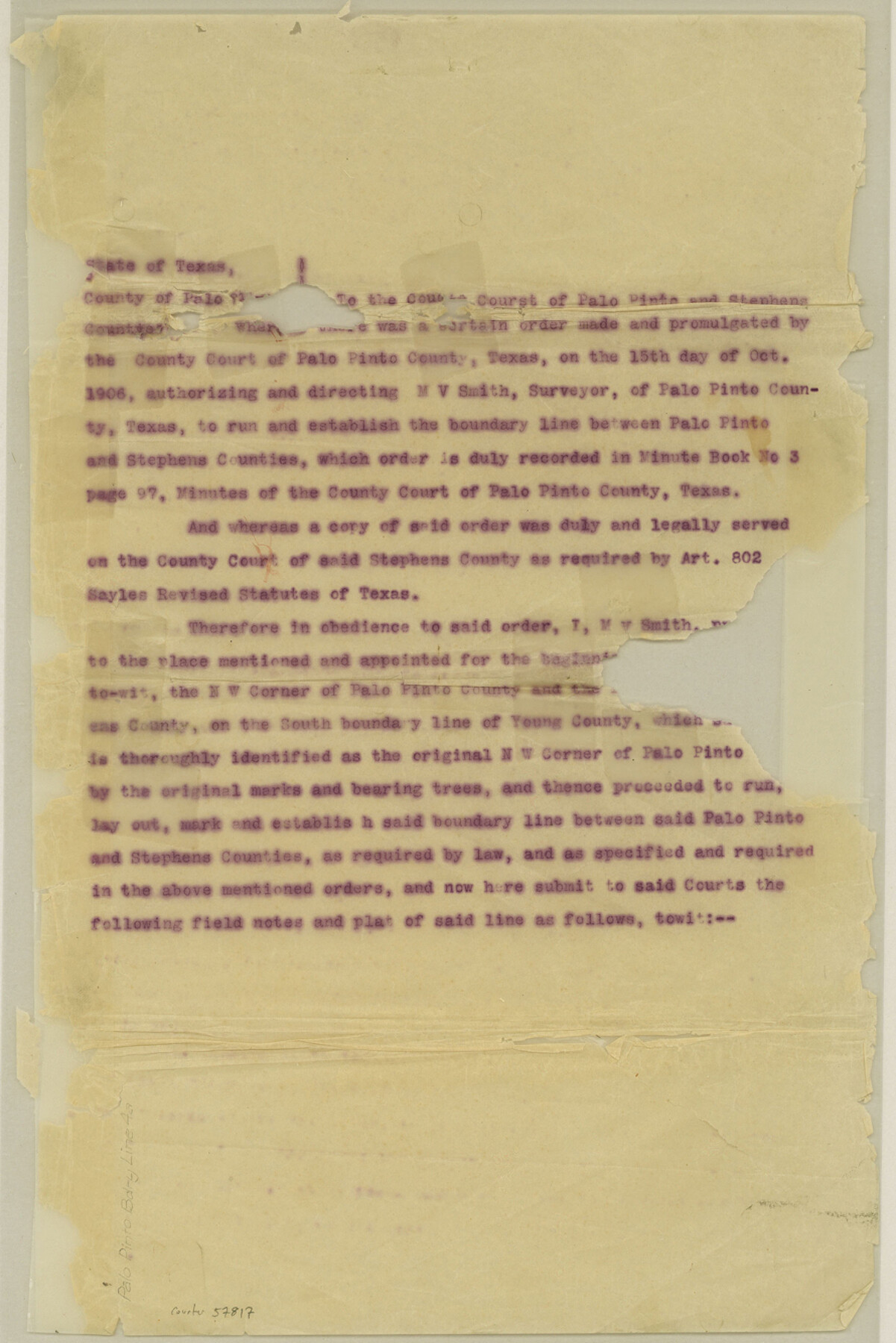
Palo Pinto County Boundary File 4a
Western Line Palo Pinto
-
Map/Doc
57817
-
Collection
General Map Collection
-
Counties
Palo Pinto
-
Subjects
County Boundaries
-
Height x Width
13.3 x 8.9 inches
33.8 x 22.6 cm
Part of: General Map Collection
Howard County Working Sketch 6

Print $20.00
- Digital $50.00
Howard County Working Sketch 6
1946
Size 17.3 x 19.5 inches
Map/Doc 66272

Limestone County Working Sketch 9

Print $20.00
- Digital $50.00
Limestone County Working Sketch 9
1922
Size 18.5 x 19.2 inches
Map/Doc 70559
Map of Part of Espiritu Santo and San Antonio Bays and Vicinity, Texas

Print $40.00
- Digital $50.00
Map of Part of Espiritu Santo and San Antonio Bays and Vicinity, Texas
1859
Size 31.6 x 53.1 inches
Map/Doc 69983

Cherokee County Working Sketch 22

Print $20.00
- Digital $50.00
Cherokee County Working Sketch 22
1972
Size 24.0 x 19.2 inches
Map/Doc 67977
Matagorda County Rolled Sketch 30

Print $20.00
- Digital $50.00
Matagorda County Rolled Sketch 30
1937
Size 24.9 x 35.0 inches
Map/Doc 6693
Dallam County

Print $40.00
- Digital $50.00
Dallam County
1926
Size 39.9 x 48.6 inches
Map/Doc 95474
Topographical Map of the Rio Grande, Sheet No. 29

Print $20.00
- Digital $50.00
Topographical Map of the Rio Grande, Sheet No. 29
1912
Map/Doc 89553
Galveston to Rio Grande

Print $20.00
- Digital $50.00
Galveston to Rio Grande
1961
Size 44.4 x 37.2 inches
Map/Doc 69954
Panola County Working Sketch 16

Print $20.00
- Digital $50.00
Panola County Working Sketch 16
1945
Map/Doc 71425
Hunt County Sketch File 33

Print $4.00
- Digital $50.00
Hunt County Sketch File 33
1864
Size 7.1 x 5.0 inches
Map/Doc 27141
You may also like
Edwards County Sketch File 29

Print $40.00
- Digital $50.00
Edwards County Sketch File 29
Size 19.4 x 15.9 inches
Map/Doc 11432
La Salle County Sketch File 20A

Print $29.00
- Digital $50.00
La Salle County Sketch File 20A
1852
Size 19.5 x 33.6 inches
Map/Doc 11984
Grimes County Working Sketch 2

Print $20.00
- Digital $50.00
Grimes County Working Sketch 2
1941
Size 13.2 x 20.9 inches
Map/Doc 63293
Dimmit County Working Sketch 55

Print $20.00
- Digital $50.00
Dimmit County Working Sketch 55
1996
Size 33.7 x 34.3 inches
Map/Doc 68716
Flight Mission No. DIX-8P, Frame 88, Aransas County

Print $20.00
- Digital $50.00
Flight Mission No. DIX-8P, Frame 88, Aransas County
1956
Size 18.6 x 22.3 inches
Map/Doc 83913
[Working Sketch in Martin County Showing Northwest Portion of County]
![91355, [Working Sketch in Martin County Showing Northwest Portion of County], Twichell Survey Records](https://historictexasmaps.com/wmedia_w700/maps/91355-1.tif.jpg)
Print $20.00
- Digital $50.00
[Working Sketch in Martin County Showing Northwest Portion of County]
1902
Size 17.1 x 36.0 inches
Map/Doc 91355
Greenville, Hunt County, Texas

Print $20.00
Greenville, Hunt County, Texas
1891
Size 21.9 x 36.5 inches
Map/Doc 79749
Jim Hogg County Rolled Sketch 3

Print $20.00
- Digital $50.00
Jim Hogg County Rolled Sketch 3
1912
Size 28.2 x 20.2 inches
Map/Doc 6439
Swisher County Boundary File 2

Print $106.00
- Digital $50.00
Swisher County Boundary File 2
Size 14.3 x 9.0 inches
Map/Doc 59093
Kerr County Sketch File 18

Print $20.00
- Digital $50.00
Kerr County Sketch File 18
1950
Size 16.9 x 20.3 inches
Map/Doc 11921

Nueces County Sketch File 52

Print $10.00
- Digital $50.00
Nueces County Sketch File 52
1947
Size 14.1 x 8.6 inches
Map/Doc 32858