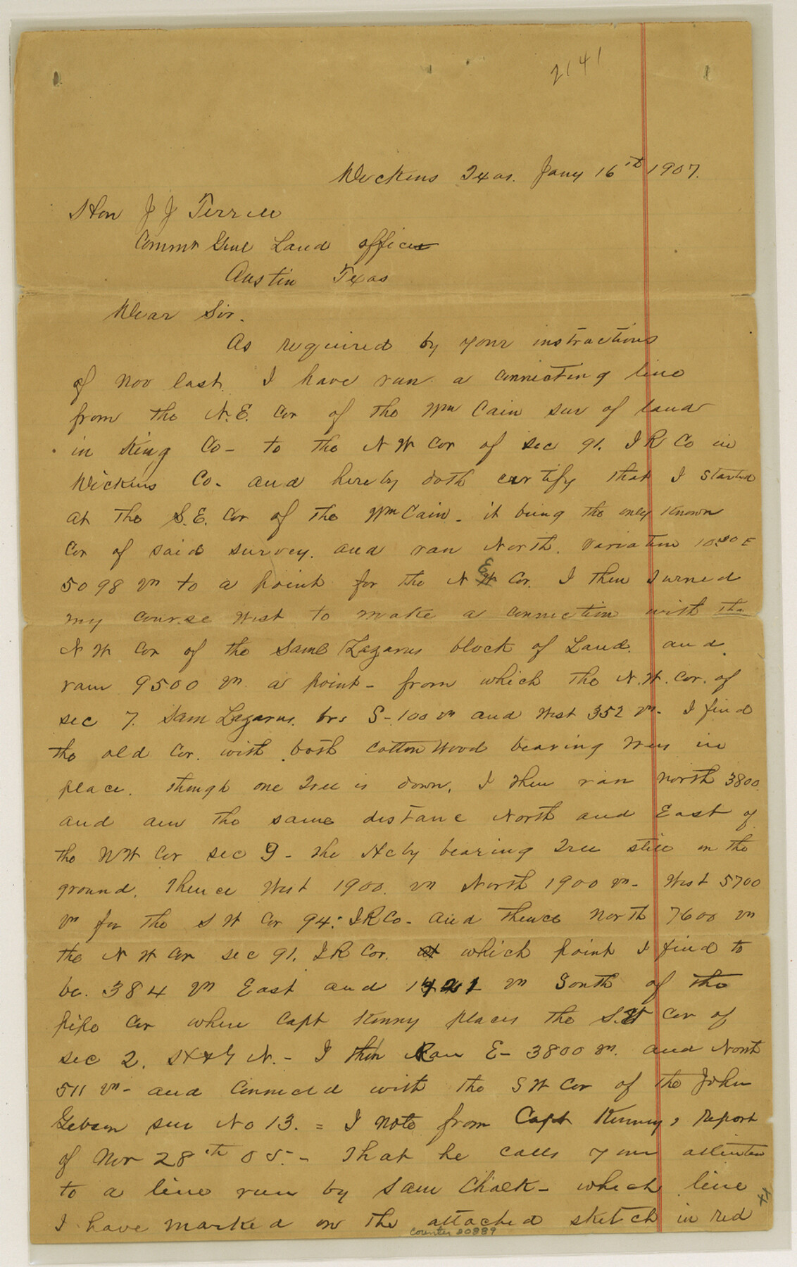
Dickens County Sketch File K
[Connecting line from the northeast corner of the William Cain survey to the northwest corner of section 91, I. R. Co.]
-
Map/Doc
20889
-
Collection
General Map Collection
-
Object Dates
1907/1/16 (Creation Date)
1907/1/21 (File Date)
-
People and Organizations
Jno. A. Green (Surveyor/Engineer)
Samuel Chalk (Surveyor/Engineer)
Captain Kenney (Surveyor/Engineer)
-
Counties
Dickens King
-
Subjects
Surveying Sketch File
-
Height x Width
14.5 x 9.1 inches
36.8 x 23.1 cm
-
Medium
paper, manuscript
Part of: General Map Collection
United States and Territories, showing the extent of Public Surveys, Indian and Forest Reservations, Rail Roads, Canals and other detail, compiled from official surveys of the General Land Office and other authentic sources

Print $40.00
- Digital $50.00
United States and Territories, showing the extent of Public Surveys, Indian and Forest Reservations, Rail Roads, Canals and other detail, compiled from official surveys of the General Land Office and other authentic sources
1897
Size 59.5 x 85.8 inches
Map/Doc 93969
Harbor Pass and Bar at Brazos Santiago, Texas

Print $20.00
- Digital $50.00
Harbor Pass and Bar at Brazos Santiago, Texas
1879
Size 18.2 x 27.2 inches
Map/Doc 73001
Presidio County Working Sketch 7

Print $20.00
- Digital $50.00
Presidio County Working Sketch 7
1926
Size 35.0 x 40.0 inches
Map/Doc 71681
Map of Bryan, Brazos County, Texas

Print $20.00
- Digital $50.00
Map of Bryan, Brazos County, Texas
1915
Size 18.5 x 24.6 inches
Map/Doc 3210
Hartley County Rolled Sketch 9

Print $20.00
- Digital $50.00
Hartley County Rolled Sketch 9
2001
Size 22.7 x 34.7 inches
Map/Doc 76407
Kerr County Working Sketch 7

Print $20.00
- Digital $50.00
Kerr County Working Sketch 7
1947
Size 38.9 x 30.8 inches
Map/Doc 70038
Hutchinson County Working Sketch 25

Print $20.00
- Digital $50.00
Hutchinson County Working Sketch 25
1972
Size 21.5 x 25.0 inches
Map/Doc 66385
Jefferson County Working Sketch 13

Print $20.00
- Digital $50.00
Jefferson County Working Sketch 13
1948
Size 13.5 x 20.1 inches
Map/Doc 66556

Travis County

Print $40.00
- Digital $50.00
Travis County
1880
Size 59.0 x 70.2 inches
Map/Doc 16902
Northeast Part of Webb County

Print $40.00
- Digital $50.00
Northeast Part of Webb County
1986
Size 37.7 x 50.0 inches
Map/Doc 95668
Hardeman County

Print $20.00
- Digital $50.00
Hardeman County
1876
Size 24.1 x 31.5 inches
Map/Doc 3625
You may also like
Bee County Sketch File 13

Print $4.00
- Digital $50.00
Bee County Sketch File 13
1876
Size 12.6 x 8.1 inches
Map/Doc 14295
Harris County State Real Property Sketch 5

Print $20.00
- Digital $50.00
Harris County State Real Property Sketch 5
2003
Size 24.5 x 36.0 inches
Map/Doc 82007
Right of Way and Track Map, Dayton-Goose Creek Ry. Co., Station 401+20 to Station 612+40
Print $40.00
- Digital $50.00
Right of Way and Track Map, Dayton-Goose Creek Ry. Co., Station 401+20 to Station 612+40
1917
Size 25.4 x 56.4 inches
Map/Doc 64367
Presidio County Working Sketch 97

Print $20.00
- Digital $50.00
Presidio County Working Sketch 97
1978
Size 28.2 x 28.0 inches
Map/Doc 71774
Nouvelle Carte du Mexique du Texas et d'une partie des états limitrophes

Print $20.00
- Digital $50.00
Nouvelle Carte du Mexique du Texas et d'une partie des états limitrophes
1834
Size 39.9 x 27.4 inches
Map/Doc 94098
Laguna Madre, Register No. 1476B

Print $40.00
- Digital $50.00
Laguna Madre, Register No. 1476B
1880
Size 33.7 x 56.2 inches
Map/Doc 73605
Hardeman County Sketch File 32

Print $4.00
- Digital $50.00
Hardeman County Sketch File 32
Size 11.1 x 8.9 inches
Map/Doc 25068
Flight Mission No. CUI-1H, Frame 141, Milam County

Print $20.00
- Digital $50.00
Flight Mission No. CUI-1H, Frame 141, Milam County
1951
Size 18.4 x 22.3 inches
Map/Doc 86607
Newton County Sketch File 7

Print $4.00
- Digital $50.00
Newton County Sketch File 7
1872
Size 6.1 x 8.3 inches
Map/Doc 32374
Rusk County Working Sketch 7

Print $20.00
- Digital $50.00
Rusk County Working Sketch 7
1982
Size 22.3 x 36.7 inches
Map/Doc 63642
Garza County Rolled Sketch 6D

Print $20.00
- Digital $50.00
Garza County Rolled Sketch 6D
1913
Size 17.4 x 16.0 inches
Map/Doc 5998
Texas-United States Boundary Line 2

Print $22.00
- Digital $50.00
Texas-United States Boundary Line 2
1882
Size 8.3 x 7.3 inches
Map/Doc 74976