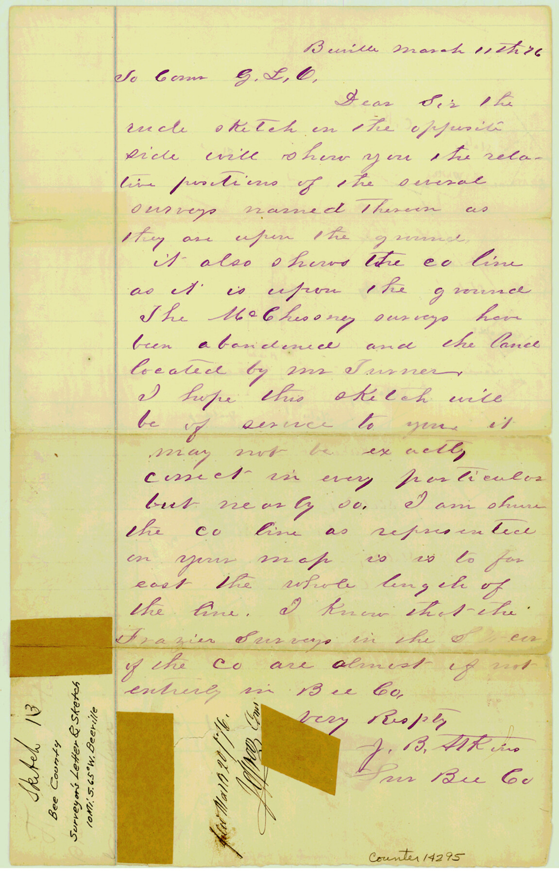
Bee County Sketch File 13
[Surveyor's letter and sketch of area southwest of Beeville along Live Oak-Bee County line]
- 
                          Map/Doc
14295
 - 
                            Collection
General Map Collection
 - 
                            Object Dates
1876/3/11 (Creation Date)
1876/3/20 (File Date)
 - 
                            People and Organizations
J.B. Atkins (Surveyor/Engineer)
 - 
                            Counties
Bee Live Oak
 - 
                            Subjects
Surveying Sketch File
 - 
                            Height x Width
12.6 x 8.1 inches
32.0 x 20.6 cm
 - 
                            Medium
paper, manuscript
 
Part of: General Map Collection
            Trinity County Sketch File 36


                                            Print $20.00                    
                                             -                         Digital $50.00                                    
                Trinity County Sketch File 36
Size 43.4 x 18.1 inches
                                Map/Doc 10408
            
            Map showing the fortification at Point Isabel


                                            Print $20.00                    
                                             -                         Digital $50.00                                    
                Map showing the fortification at Point Isabel
1864
Size 18.3 x 27.9 inches
                                Map/Doc 72921
            
            Cram's Superior Map of Illinois


                                            Print $40.00                    
                                             -                         Digital $50.00                                    
                Cram's Superior Map of Illinois
1903
Size 50.2 x 40.5 inches
                                Map/Doc 97110
            
            Irion County Working Sketch 3


                                            Print $40.00                    
                                             -                         Digital $50.00                                    
                Irion County Working Sketch 3
1921
Size 16.1 x 49.3 inches
                                Map/Doc 66412
            
            Clay County Sketch File 5


                                            Print $5.00                    
                                             -                         Digital $50.00                                    
                Clay County Sketch File 5
1859
Size 8.6 x 3.8 inches
                                Map/Doc 18393
            
            Chambers County NRC Article 33.136 Sketch 8


                                            Print $22.00                    
                                             -                         Digital $50.00                                    
                Chambers County NRC Article 33.136 Sketch 8
2014
Size 17.7 x 24.0 inches
                                Map/Doc 94745
            
            Travis County Sketch File 57


                                            Print $8.00                    
                                             -                         Digital $50.00                                    
                Travis County Sketch File 57
1947
Size 11.4 x 8.8 inches
                                Map/Doc 38402
            
            Medina County Rolled Sketch 14


                                            Print $20.00                    
                                             -                         Digital $50.00                                    
                Medina County Rolled Sketch 14
1980
Size 29.2 x 32.0 inches
                                Map/Doc 6748
            
            Shelby County Sketch File 10


                                            Print $4.00                    
                                             -                         Digital $50.00                                    
                Shelby County Sketch File 10
Size 6.6 x 7.4 inches
                                Map/Doc 36611
            
            [Sketch for Mineral Application 33721 - 33725  Incl. - Padre and Mustang Island]


                                            Print $20.00                    
                                             -                         Digital $50.00                                    
                [Sketch for Mineral Application 33721 - 33725 Incl. - Padre and Mustang Island]
1942
Size 29.7 x 22.3 inches
                                Map/Doc 2868
            
            Robertson County Sketch File 1


                                            Print $7.00                    
                                             -                         Digital $50.00                                    
                Robertson County Sketch File 1
1857
Size 12.8 x 8.2 inches
                                Map/Doc 35340
            
            [Surveys in Austin's Colony along the Brazos River and Oyster Creek]


                                            Print $20.00                    
                                             -                         Digital $50.00                                    
                [Surveys in Austin's Colony along the Brazos River and Oyster Creek]
1824
Size 23.1 x 17.2 inches
                                Map/Doc 206
            You may also like
            Flight Mission No. CUI-1H, Frame 168, Milam County


                                            Print $20.00                    
                                             -                         Digital $50.00                                    
                Flight Mission No. CUI-1H, Frame 168, Milam County
1951
Size 18.4 x 22.3 inches
                                Map/Doc 86610
            
            Upton County Rolled Sketch 32


                                            Print $20.00                    
                                             -                         Digital $50.00                                    
                Upton County Rolled Sketch 32
Size 38.6 x 39.0 inches
                                Map/Doc 10049
            
            Town of Wellman Situated on Parts of the Northeast 1/4 and Northwest 1/4 Section 17, Block DD


                                            Print $20.00                    
                                             -                         Digital $50.00                                    
                Town of Wellman Situated on Parts of the Northeast 1/4 and Northwest 1/4 Section 17, Block DD
1924
Size 14.3 x 12.3 inches
                                Map/Doc 92886
            
            General Highway Map, Sherman County, Texas


                                            Print $20.00                    
                                    
                General Highway Map, Sherman County, Texas
1961
Size 18.2 x 24.8 inches
                                Map/Doc 79653
            
            Blanco County Sketch File 12


                                            Print $20.00                    
                                             -                         Digital $50.00                                    
                Blanco County Sketch File 12
Size 15.0 x 19.8 inches
                                Map/Doc 10928
            
            Uvalde County


                                            Print $20.00                    
                                             -                         Digital $50.00                                    
                Uvalde County
1915
Size 42.9 x 46.2 inches
                                Map/Doc 63091
            
            Van Zandt County Sketch File 47


                                            Print $7.00                    
                                             -                         Digital $50.00                                    
                Van Zandt County Sketch File 47
Size 10.0 x 8.1 inches
                                Map/Doc 39504
            
            Montgomery County Sketch File 39


                                            Print $4.00                    
                                             -                         Digital $50.00                                    
                Montgomery County Sketch File 39
1941
Size 14.6 x 8.6 inches
                                Map/Doc 31923
            
            Morris County Boundary File 3


                                            Print $6.00                    
                                             -                         Digital $50.00                                    
                Morris County Boundary File 3
Size 10.8 x 8.1 inches
                                Map/Doc 57485
            
            Taylor County Rolled Sketch 30A


                                            Print $20.00                    
                                             -                         Digital $50.00                                    
                Taylor County Rolled Sketch 30A
Size 17.5 x 11.3 inches
                                Map/Doc 76410
            
            Tanglewood, Station Map-Tracks & Structures-Lands, San Antonio & Aransas Pass Railway Co., Station 4804+179 to Station 4856+179


                                            Print $4.00                    
                                             -                         Digital $50.00                                    
                Tanglewood, Station Map-Tracks & Structures-Lands, San Antonio & Aransas Pass Railway Co., Station 4804+179 to Station 4856+179
1919
Size 11.7 x 18.6 inches
                                Map/Doc 62569