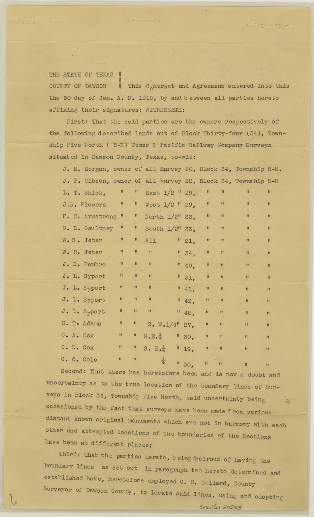
Dawson County Sketch File 17
[Boundary agreement regarding Block 34, Township 5 North]
-
Map/Doc
20558
-
Collection
General Map Collection
-
Object Dates
1937/7/19 (File Date)
-
People and Organizations
C.B. Collard (Surveyor/Engineer)
-
Counties
Dawson Palo Pinto
-
Subjects
Surveying Sketch File
-
Height x Width
14.4 x 8.8 inches
36.6 x 22.4 cm
-
Medium
paper, print
Part of: General Map Collection
Starr County Sketch File 18

Print $20.00
- Digital $50.00
Starr County Sketch File 18
1880
Size 38.2 x 25.1 inches
Map/Doc 10606
Bastrop County Sketch File 11

Print $52.00
- Digital $50.00
Bastrop County Sketch File 11
Size 11.2 x 8.7 inches
Map/Doc 14058
Galveston County NRC Article 33.136 Sketch 23

Print $22.00
- Digital $50.00
Galveston County NRC Article 33.136 Sketch 23
2002
Size 11.4 x 16.4 inches
Map/Doc 81905
Sutton County Sketch File 7

Print $4.00
- Digital $50.00
Sutton County Sketch File 7
Size 10.6 x 8.7 inches
Map/Doc 37365
St. Louis, Brownsville & Mexico Railway Location Map from Mile 100 to Mile 120

Print $40.00
- Digital $50.00
St. Louis, Brownsville & Mexico Railway Location Map from Mile 100 to Mile 120
1905
Size 20.0 x 61.2 inches
Map/Doc 64167
Tarrant County Sketch File 29a

Print $4.00
- Digital $50.00
Tarrant County Sketch File 29a
1876
Size 8.2 x 12.8 inches
Map/Doc 37747
Brewster County Working Sketch 71a

Print $40.00
- Digital $50.00
Brewster County Working Sketch 71a
1962
Size 43.5 x 56.0 inches
Map/Doc 67869
Galveston County NRC Article 33.136 Sketch 100

Print $46.00
Galveston County NRC Article 33.136 Sketch 100
2024
Map/Doc 97423
Roberts County Working Sketch 20

Print $20.00
- Digital $50.00
Roberts County Working Sketch 20
1977
Size 25.6 x 32.9 inches
Map/Doc 63546
Reeves County Working Sketch 25

Print $40.00
- Digital $50.00
Reeves County Working Sketch 25
1966
Size 31.4 x 59.0 inches
Map/Doc 63468
Index sheet to accompany map of survey for connecting the inland waters along margin of the Gulf of Mexico from Donaldsonville in Louisiana to the Rio Grande River in Texas

Print $20.00
- Digital $50.00
Index sheet to accompany map of survey for connecting the inland waters along margin of the Gulf of Mexico from Donaldsonville in Louisiana to the Rio Grande River in Texas
1874
Size 18.1 x 26.9 inches
Map/Doc 72694
Intracoastal Waterway - Port Arthur to Galveston Bay

Print $20.00
- Digital $50.00
Intracoastal Waterway - Port Arthur to Galveston Bay
1960
Size 26.7 x 38.8 inches
Map/Doc 69832
You may also like

Bee County Sketch File 2

Print $40.00
- Digital $50.00
Bee County Sketch File 2
Size 14.3 x 13.0 inches
Map/Doc 14259
Val Verde County Working Sketch 81

Print $20.00
- Digital $50.00
Val Verde County Working Sketch 81
1973
Size 24.6 x 41.7 inches
Map/Doc 72216
Bowie County Sketch File 7b

Print $10.00
- Digital $50.00
Bowie County Sketch File 7b
1927
Size 10.7 x 8.6 inches
Map/Doc 14859
[Sketch of Blocks D5-D8]
![93046, [Sketch of Blocks D5-D8], Twichell Survey Records](https://historictexasmaps.com/wmedia_w700/maps/93046-1.tif.jpg)
Print $20.00
- Digital $50.00
[Sketch of Blocks D5-D8]
Size 43.1 x 28.3 inches
Map/Doc 93046
Camp County Working Sketch 2

Print $20.00
- Digital $50.00
Camp County Working Sketch 2
1975
Size 24.8 x 24.5 inches
Map/Doc 67878
McMullen County Working Sketch 29

Print $40.00
- Digital $50.00
McMullen County Working Sketch 29
1956
Size 59.0 x 37.2 inches
Map/Doc 70730
Culberson County Working Sketch 32

Print $20.00
- Digital $50.00
Culberson County Working Sketch 32
1958
Size 45.3 x 38.0 inches
Map/Doc 68485
Scurry County Sketch File 6

Print $14.00
- Digital $50.00
Scurry County Sketch File 6
2002
Size 11.2 x 8.7 inches
Map/Doc 76370
Crane County Working Sketch 11

Print $20.00
- Digital $50.00
Crane County Working Sketch 11
1941
Size 18.8 x 18.4 inches
Map/Doc 68288
Brazoria County Sketch File 4

Print $4.00
- Digital $50.00
Brazoria County Sketch File 4
1861
Size 7.9 x 9.5 inches
Map/Doc 14927
Mitchell County Sketch File X

Print $20.00
- Digital $50.00
Mitchell County Sketch File X
1908
Size 29.9 x 17.7 inches
Map/Doc 12104