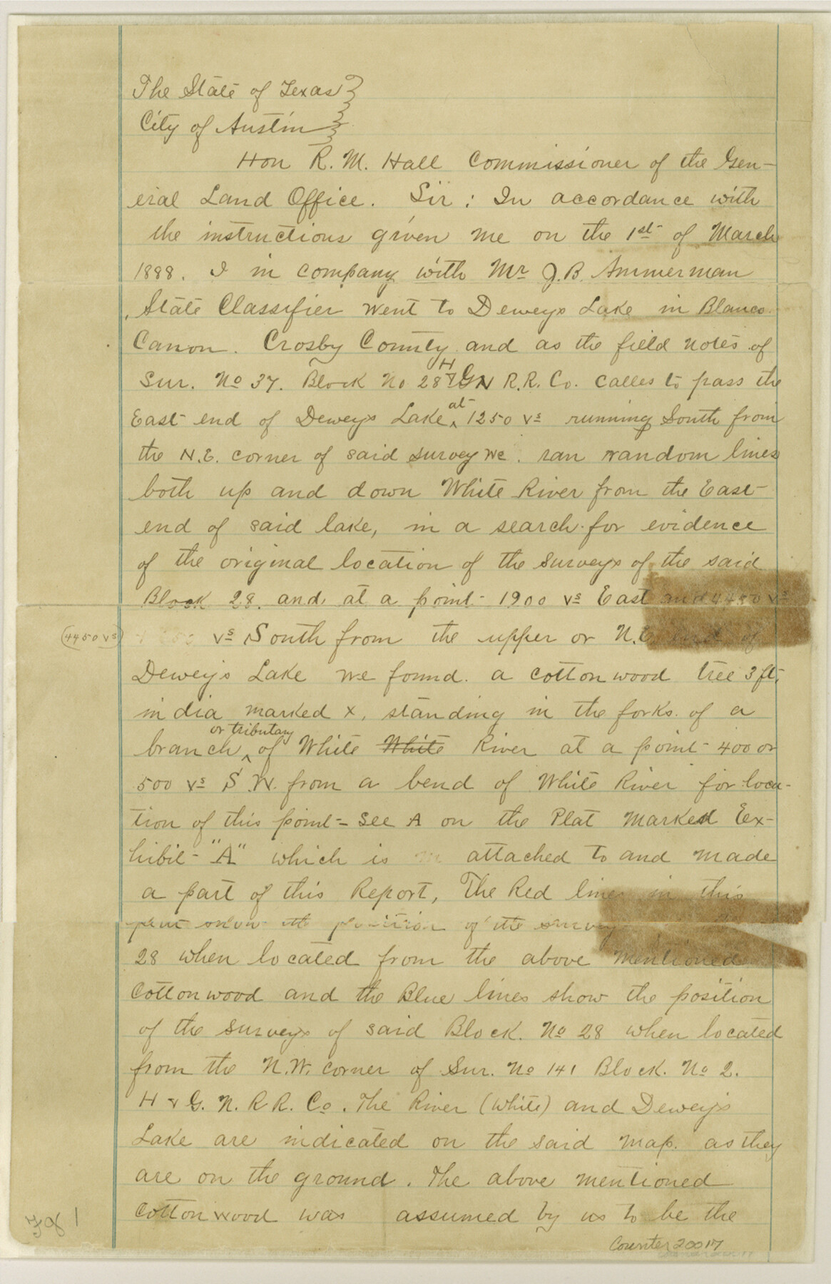
Crosby County Sketch File 11
Plat Showing Block 28 H and GN R.R. Co.
-
Map/Doc
20017
-
Collection
General Map Collection
-
Object Dates
1888/4/26 (File Date)
-
People and Organizations
G.M. Williams (Surveyor/Engineer)
T.J. McClellan (Surveyor/Engineer)
L.J. Cook (Chainman)
L.C. Janewer (Chainman)
-
Counties
Crosby Floyd
-
Subjects
Surveying Sketch File
-
Height x Width
13.8 x 8.9 inches
35.1 x 22.6 cm
-
Medium
paper, manuscript
-
Features
Dewey's Lake
Blanco Canon
White River
Brokenbough Creek
Waddell Creek
Estacado Road
Crawfish Draw
Estacado
Yellowhouse Creek
North Fork of Yellowhouse Creek
De La Plain
Gen. McKenzie's Old Trail
Part of: General Map Collection
Hall County Sketch File C

Print $20.00
- Digital $50.00
Hall County Sketch File C
1905
Size 13.7 x 32.8 inches
Map/Doc 11614
Runnels County Rolled Sketch 46

Print $20.00
- Digital $50.00
Runnels County Rolled Sketch 46
1954
Size 33.5 x 39.0 inches
Map/Doc 9872
DeWitt County Rolled Sketch 2

Print $20.00
- Digital $50.00
DeWitt County Rolled Sketch 2
1943
Size 32.0 x 42.7 inches
Map/Doc 8778
San Augustine County Working Sketch 16

Print $20.00
- Digital $50.00
San Augustine County Working Sketch 16
1962
Size 22.2 x 25.0 inches
Map/Doc 63704
Bexar County Sketch File 56

Print $40.00
- Digital $50.00
Bexar County Sketch File 56
1966
Size 19.7 x 23.8 inches
Map/Doc 10927
Map of Comal County

Print $20.00
- Digital $50.00
Map of Comal County
1862
Size 18.6 x 22.0 inches
Map/Doc 3429
Galveston County NRC Article 33.136 Sketch 39

Print $24.00
- Digital $50.00
Galveston County NRC Article 33.136 Sketch 39
2005
Size 25.0 x 25.4 inches
Map/Doc 83084
Carte du Canada et de la Louisiane qui forment la Nouvelle France et des colonies angloises ou sont representez les pays contestez

Print $20.00
- Digital $50.00
Carte du Canada et de la Louisiane qui forment la Nouvelle France et des colonies angloises ou sont representez les pays contestez
1756
Size 21.5 x 29.6 inches
Map/Doc 97415
Flight Mission No. DCL-7C, Frame 139, Kenedy County

Print $20.00
- Digital $50.00
Flight Mission No. DCL-7C, Frame 139, Kenedy County
1943
Size 18.5 x 22.3 inches
Map/Doc 86096
Hale County Sketch File E

Print $20.00
- Digital $50.00
Hale County Sketch File E
1902
Size 15.2 x 21.5 inches
Map/Doc 11601
Right of Way and Track Map International & Gt. Northern Ry. operated by the International & Gt. Northern Ry. Co., Gulf Division, Columbia Branch

Print $40.00
- Digital $50.00
Right of Way and Track Map International & Gt. Northern Ry. operated by the International & Gt. Northern Ry. Co., Gulf Division, Columbia Branch
1912
Size 25.1 x 56.5 inches
Map/Doc 64595
Calcasieu Pass to Sabine Pass
Print $20.00
- Digital $50.00
Calcasieu Pass to Sabine Pass
1966
Size 44.9 x 35.5 inches
Map/Doc 69810
You may also like
Dawson County Boundary File 3 (2)

Print $40.00
- Digital $50.00
Dawson County Boundary File 3 (2)
Size 13.2 x 33.5 inches
Map/Doc 52367

Webb County Rolled Sketch 28

Print $20.00
- Digital $50.00
Webb County Rolled Sketch 28
1932
Size 27.5 x 20.6 inches
Map/Doc 8186
[Gulf, Colorado & Santa Fe]
![64575, [Gulf, Colorado & Santa Fe], General Map Collection](https://historictexasmaps.com/wmedia_w700/maps/64575.tif.jpg)
Print $40.00
- Digital $50.00
[Gulf, Colorado & Santa Fe]
Size 31.9 x 71.7 inches
Map/Doc 64575
Real County Rolled Sketch 12

Print $40.00
- Digital $50.00
Real County Rolled Sketch 12
Size 42.7 x 54.6 inches
Map/Doc 9836
Flight Mission No. DCL-7C, Frame 16, Kenedy County

Print $20.00
- Digital $50.00
Flight Mission No. DCL-7C, Frame 16, Kenedy County
1943
Size 15.2 x 15.4 inches
Map/Doc 86008
Flight Mission No. DQO-2K, Frame 134, Galveston County

Print $20.00
- Digital $50.00
Flight Mission No. DQO-2K, Frame 134, Galveston County
1952
Size 18.7 x 22.4 inches
Map/Doc 85031
Flight Mission No. DQN-7K, Frame 4, Calhoun County

Print $20.00
- Digital $50.00
Flight Mission No. DQN-7K, Frame 4, Calhoun County
1953
Size 18.9 x 22.1 inches
Map/Doc 84455
General Highway Map of Gaines County, Texas

Print $20.00
- Digital $50.00
General Highway Map of Gaines County, Texas
1951
Size 19.0 x 26.2 inches
Map/Doc 92644
Upton County Working Sketch 51

Print $20.00
- Digital $50.00
Upton County Working Sketch 51
1980
Size 19.1 x 30.0 inches
Map/Doc 69548
Freestone County

Print $20.00
- Digital $50.00
Freestone County
1918
Size 46.8 x 39.8 inches
Map/Doc 4702
McMullen County Rolled Sketch 11

Print $20.00
- Digital $50.00
McMullen County Rolled Sketch 11
Size 32.2 x 22.3 inches
Map/Doc 6728