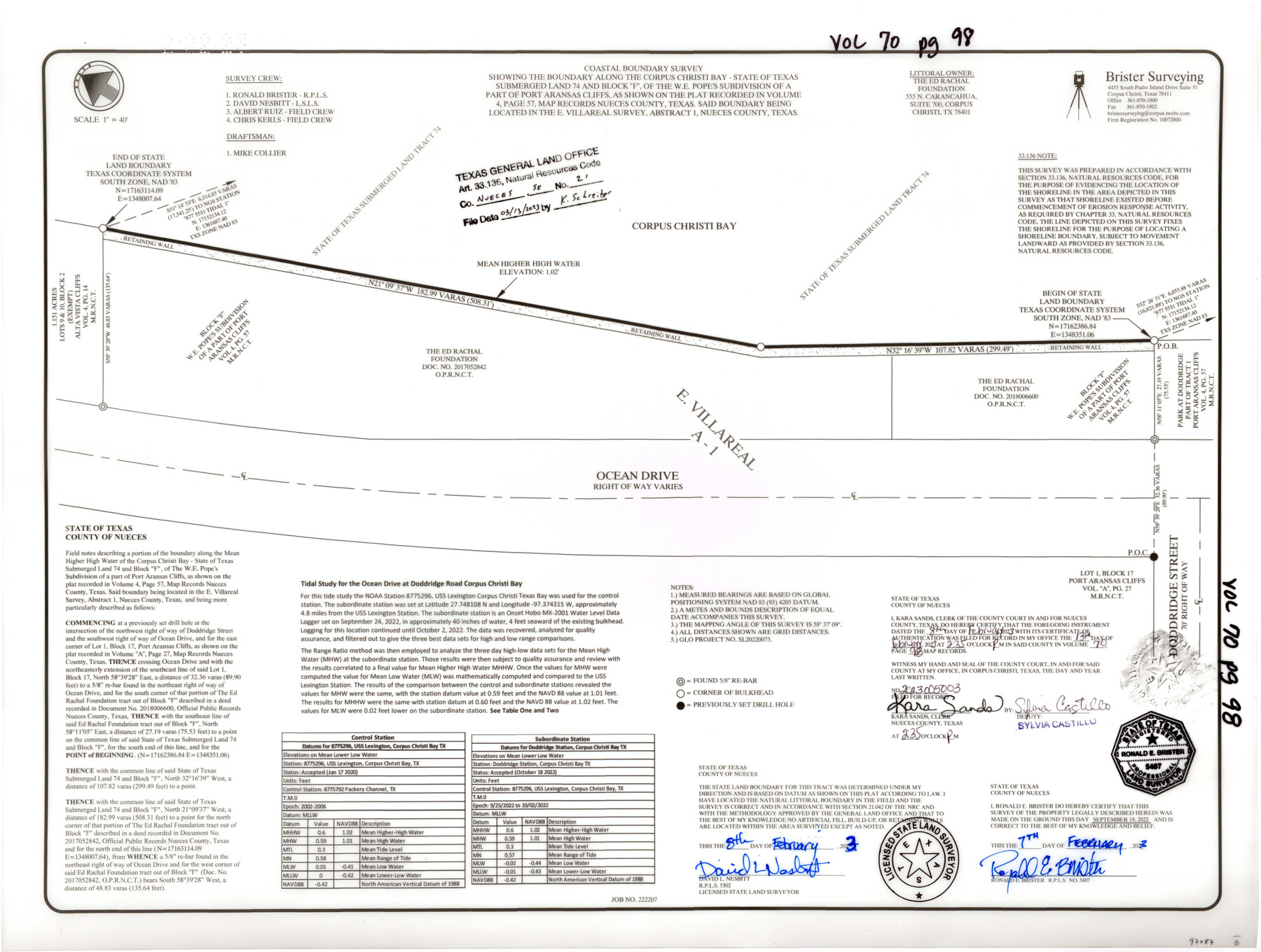
Nueces County NRC Article 33.136 Sketch 21
Coastal Boundary Survey showing the boundary along the Corpus Christi Bay - State of Texas Submerged Land 74 and Block "F" of the W.E. Pope's subdivision of a part of Port Aransas Cliffs said boundary being located in the E. Villareal survey, abstract 1
Project: Corpus Christi Bay - State of Texas Submerged Land 74 and Block "F" of the W.E. Pope's Subdivision of a part of Port Aransas Cliffs, as shown on the plat recorded in Volume 4, Page 57, Map Records Nueces County / Project No.: GLO Project No. SL-20220073
-
Map/Doc
97087
-
Collection
General Map Collection
-
Object Dates
2/8/2023 (Creation Date)
3/13/2023 (File Date)
-
People and Organizations
David L. Nesbitt (Surveyor/Engineer)
Ronald Brister (Surveyor/Engineer)
Mike Collier (Draftsman)
Albert Ruiz (Chainman/Field Personnel)
Chris Kerls (Chainman/Field Personnel)
-
Counties
Nueces
-
Subjects
Surveying CBS
-
Medium
multi-page, multi-format
Part of: General Map Collection
Flight Mission No. BRA-17M, Frame 6, Jefferson County

Print $20.00
- Digital $50.00
Flight Mission No. BRA-17M, Frame 6, Jefferson County
1953
Size 18.5 x 22.2 inches
Map/Doc 85787
Grimes County Working Sketch Graphic Index

Print $40.00
- Digital $50.00
Grimes County Working Sketch Graphic Index
1922
Size 54.9 x 29.4 inches
Map/Doc 76560
Map of Stephens Buchanan County north of the Clearfork of the Brazos River, Young- the balance Milam- Land- District

Print $20.00
- Digital $50.00
Map of Stephens Buchanan County north of the Clearfork of the Brazos River, Young- the balance Milam- Land- District
1859
Size 24.4 x 19.6 inches
Map/Doc 4052
Menard County Rolled Sketch 2

Print $20.00
- Digital $50.00
Menard County Rolled Sketch 2
1883
Size 25.0 x 19.9 inches
Map/Doc 6752
Calhoun County Aerial Photograph Index Sheet 6

Print $20.00
- Digital $50.00
Calhoun County Aerial Photograph Index Sheet 6
1953
Size 24.0 x 19.3 inches
Map/Doc 83674
Reagan County

Print $40.00
- Digital $50.00
Reagan County
1940
Size 48.4 x 37.5 inches
Map/Doc 73270
Section IX, Galveston Harbor and Bar

Print $20.00
- Digital $50.00
Section IX, Galveston Harbor and Bar
1850
Size 30.0 x 45.7 inches
Map/Doc 69855
Wharton County Boundary File 1b

Print $20.00
- Digital $50.00
Wharton County Boundary File 1b
Size 15.1 x 26.6 inches
Map/Doc 59855
[Surveys in the Milam District Near the Upper San Gabriel River]
![247, [Surveys in the Milam District Near the Upper San Gabriel River], General Map Collection](https://historictexasmaps.com/wmedia_w700/maps/247.tif.jpg)
Print $20.00
- Digital $50.00
[Surveys in the Milam District Near the Upper San Gabriel River]
1845
Size 12.3 x 15.7 inches
Map/Doc 247
Dickens County Boundary File 1

Print $6.00
- Digital $50.00
Dickens County Boundary File 1
Size 8.8 x 3.7 inches
Map/Doc 52530
Travis County Sketch File 45

Print $20.00
- Digital $50.00
Travis County Sketch File 45
1937
Size 22.7 x 37.8 inches
Map/Doc 12467
[Travis Station Map - Tracks and Structures - Lands. San Antonio & Aransas Pass Railway Co.]
![62564, [Travis Station Map - Tracks and Structures - Lands. San Antonio & Aransas Pass Railway Co.], General Map Collection](https://historictexasmaps.com/wmedia_w700/maps/62564.tif.jpg)
Print $4.00
- Digital $50.00
[Travis Station Map - Tracks and Structures - Lands. San Antonio & Aransas Pass Railway Co.]
1919
Size 11.7 x 18.7 inches
Map/Doc 62564
You may also like
Flight Mission No. BRE-1P, Frame 74, Nueces County

Print $20.00
- Digital $50.00
Flight Mission No. BRE-1P, Frame 74, Nueces County
1956
Size 18.5 x 22.3 inches
Map/Doc 86656
Capitol Lands Surveyed by J. T. Munson

Print $20.00
- Digital $50.00
Capitol Lands Surveyed by J. T. Munson
Size 25.8 x 19.4 inches
Map/Doc 90597
[Capitol Leagues 294, 295, 301, 302, 303, and 304]
![91422, [Capitol Leagues 294, 295, 301, 302, 303, and 304], Twichell Survey Records](https://historictexasmaps.com/wmedia_w700/maps/91422-1.tif.jpg)
Print $20.00
- Digital $50.00
[Capitol Leagues 294, 295, 301, 302, 303, and 304]
1883
Size 16.1 x 12.5 inches
Map/Doc 91422
Cooke County Working Sketch 6

Print $20.00
- Digital $50.00
Cooke County Working Sketch 6
1935
Size 21.4 x 22.1 inches
Map/Doc 68243
Marble Falls City, Burnet County, Texas

Print $20.00
- Digital $50.00
Marble Falls City, Burnet County, Texas
1890
Size 26.6 x 20.5 inches
Map/Doc 4830
Newton County Sketch File 14

Print $6.00
- Digital $50.00
Newton County Sketch File 14
Size 16.4 x 10.2 inches
Map/Doc 32388
Pecos County Rolled Sketch 106

Print $40.00
- Digital $50.00
Pecos County Rolled Sketch 106
1940
Size 45.1 x 58.4 inches
Map/Doc 9718
Colorado County Working Sketch 35

Print $20.00
- Digital $50.00
Colorado County Working Sketch 35
Size 19.8 x 15.8 inches
Map/Doc 76065
Map Showing the Relative Positions of the Various Surveys Delineated Thereon

Print $20.00
- Digital $50.00
Map Showing the Relative Positions of the Various Surveys Delineated Thereon
Size 23.0 x 18.6 inches
Map/Doc 91500
Flight Mission No. BQR-9K, Frame 7, Brazoria County

Print $20.00
- Digital $50.00
Flight Mission No. BQR-9K, Frame 7, Brazoria County
1952
Size 18.7 x 22.5 inches
Map/Doc 84036
Bosque County Working Sketch 16

Print $20.00
- Digital $50.00
Bosque County Working Sketch 16
1974
Size 40.5 x 33.2 inches
Map/Doc 67449
Flight Mission No. DAG-23K, Frame 165, Matagorda County

Print $20.00
- Digital $50.00
Flight Mission No. DAG-23K, Frame 165, Matagorda County
1953
Size 17.0 x 19.0 inches
Map/Doc 86503