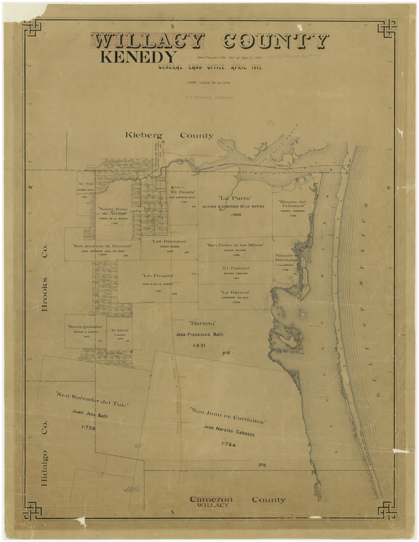
Kenedy County
-
Map/Doc
1873
-
Collection
General Map Collection
-
Object Dates
4/1913 (Creation Date)
-
People and Organizations
Texas General Land Office (Publisher)
H.F. McDonald (Compiler)
H.F. McDonald (Draftsman)
-
Counties
Kenedy
-
Subjects
County
-
Height x Width
40.2 x 31.1 inches
102.1 x 79.0 cm
-
Comments
Formerly called Willacy County.
Conservation funded in 2002 with donation from King Ranch, Incorporated. -
Features
Mesquite Lake
Potrero Cortado
Gulf of Mexico
Laguna Madre
Mud Flats
Potrero de los Cabullos [sic]
Potrero Grande
Potrero de las Canelas
Potrero Favias
Potrero Lopeña
Cuba Island
Turcotte
Katherine
Candelaria Hill
Norias
Rudolph
San Juan [Lake]
Yturria
Lago Sal Vieja
Griffins Point
Riviera
R&W
Grullo Beach
Bovido Creek
Riviera Beach
Laguna de los Olmos
Agua Dulce Creek
Baffin's Bay
Kenedy
Spohn
Penascal Rincon
Boggy Slough
Murdocks Landing
Sarita
Mifflin
Olmos Creek
SLB&M
Padre Island
Part of: General Map Collection
Edwards County Working Sketch 105

Print $40.00
- Digital $50.00
Edwards County Working Sketch 105
1972
Size 54.9 x 36.2 inches
Map/Doc 62186
Brown County Working Sketch 16

Print $20.00
- Digital $50.00
Brown County Working Sketch 16
1993
Size 46.3 x 34.7 inches
Map/Doc 67781
Flight Mission No. BRA-9M, Frame 65, Jefferson County

Print $20.00
- Digital $50.00
Flight Mission No. BRA-9M, Frame 65, Jefferson County
1953
Size 18.6 x 22.2 inches
Map/Doc 85648
San Jacinto River and Tributaries, Texas - Survey of 1939

Print $20.00
- Digital $50.00
San Jacinto River and Tributaries, Texas - Survey of 1939
1939
Size 27.7 x 40.5 inches
Map/Doc 60310
Preliminary Chart No. 31 of the Sea Coast of the United States from Galveston Bay to Matagorda Bay, Texas

Print $20.00
- Digital $50.00
Preliminary Chart No. 31 of the Sea Coast of the United States from Galveston Bay to Matagorda Bay, Texas
1857
Size 23.3 x 28.1 inches
Map/Doc 69950
Brewster County Sketch File NS-4d

Print $8.00
- Digital $50.00
Brewster County Sketch File NS-4d
Size 14.0 x 8.7 inches
Map/Doc 15961
Nueces County Rolled Sketch 39

Print $20.00
- Digital $50.00
Nueces County Rolled Sketch 39
1957
Size 32.9 x 45.3 inches
Map/Doc 6879
Flight Mission No. DQN-1K, Frame 44, Calhoun County

Print $20.00
- Digital $50.00
Flight Mission No. DQN-1K, Frame 44, Calhoun County
1953
Size 18.6 x 22.3 inches
Map/Doc 84144
Fractional Township No. 9 South Range No. 10 East of the Indian Meridian, Indian Territory

Print $20.00
- Digital $50.00
Fractional Township No. 9 South Range No. 10 East of the Indian Meridian, Indian Territory
1898
Size 19.3 x 24.3 inches
Map/Doc 75219
Flight Mission No. DIX-8P, Frame 64, Aransas County

Print $20.00
- Digital $50.00
Flight Mission No. DIX-8P, Frame 64, Aransas County
1956
Size 18.7 x 22.4 inches
Map/Doc 83895
Flight Mission No. DAH-9M, Frame 162, Orange County

Print $20.00
- Digital $50.00
Flight Mission No. DAH-9M, Frame 162, Orange County
1953
Size 18.6 x 22.3 inches
Map/Doc 86861
Flight Mission No. DIX-8P, Frame 71, Aransas County

Print $20.00
- Digital $50.00
Flight Mission No. DIX-8P, Frame 71, Aransas County
1956
Size 18.8 x 22.4 inches
Map/Doc 83902
You may also like
North end of Brazos Island

Print $20.00
- Digital $50.00
North end of Brazos Island
Size 25.9 x 18.2 inches
Map/Doc 72917

Part of Garza, Crosby, Lynn, and Lubbock Counties

Print $20.00
- Digital $50.00
Part of Garza, Crosby, Lynn, and Lubbock Counties
1912
Size 39.6 x 26.0 inches
Map/Doc 92560
Pecos County Sketch File 13

Print $20.00
- Digital $50.00
Pecos County Sketch File 13
Size 22.7 x 18.8 inches
Map/Doc 12156
Midland County Working Sketch 8

Print $20.00
- Digital $50.00
Midland County Working Sketch 8
1950
Size 41.4 x 32.9 inches
Map/Doc 70988
Brewster County Sketch File NS-4c

Print $6.00
- Digital $50.00
Brewster County Sketch File NS-4c
Size 9.2 x 7.3 inches
Map/Doc 15958
Map of the United States with its territories: also Mexico and the West Indies

Print $20.00
- Digital $50.00
Map of the United States with its territories: also Mexico and the West Indies
1851
Size 40.1 x 36.7 inches
Map/Doc 93925
Austin County

Print $20.00
- Digital $50.00
Austin County
1943
Size 38.5 x 41.3 inches
Map/Doc 77205
Andrews County Working Sketch 3

Print $40.00
- Digital $50.00
Andrews County Working Sketch 3
1953
Size 78.9 x 35.8 inches
Map/Doc 67049
Newton County Boundary File 1a

Print $20.00
- Digital $50.00
Newton County Boundary File 1a
Size 36.7 x 17.8 inches
Map/Doc 57616
Harris County NRC Article 33.136 Sketch 3

Print $26.00
- Digital $50.00
Harris County NRC Article 33.136 Sketch 3
2001
Size 18.6 x 24.8 inches
Map/Doc 61597
Kimble County Sketch File 5

Print $4.00
- Digital $50.00
Kimble County Sketch File 5
1858
Size 7.9 x 5.5 inches
Map/Doc 28916